Maps of Landkreis Ostallgäu
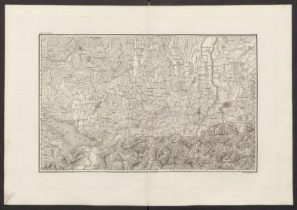
Militair Karte von Süd-Deutschland in 20 Sectionen
1 : 400000 14. Section Coulon, Alois von A. von Coulon
Karte der Bayrischen und Algäuer Alpen
1 : 250000 Allgäuské Alpy (Německo a Rakousko) Ravenstein, Ludwig L. Ravenstein
Geographica provinciarum Sueviae descriptio, 6
6 Blätter : Johann Georg Bodenehr
Carte topographique d'Allemagne contenant une partie de Bavére, de Suabe, du comté de Tirol et de l'évêché d'Augspourg, l'Algow, les quatre seigneuries autrichienne devant la montagne d'Arlenberg
1 Karte fait par I. W. Iaeger chez l'auteur, Francfort sur le Mein
[Exactissima Helvetiae, Rhaetiae, Valesiae ... tabula]
1 : 850000 9 Karten [Kopie von Adrian Braakman] [chez Pierre Schenk et Adrian Braakman], [Amsterdam]
Pars Sueviae Australior
1 : 250000 Mollova mapová sbírka Delisle, Guillaume Wolff, Jeremias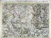
Carte topographique d'Allemagne contenant une partie de Baviére de Suabe du comté de Tirol et de l'eveché d'Augspourg
1 Karte : Kupferdruck ; 45 x 64 cm Jaeger; Facius se vend chez l'auteur
Generalkarte von Württemberg: Blatt IV
1 : 1500000 Terrainzeichnung: Bach, Topograf und Hauptmann Lithografie: Rebmann und Sommer Herausgeber: K. statistisch-topografisches Büro
Constanz - Lindau
1 : 200000 1 Karte entworfen und bearbeitet von Woerl ; in Stein gestochen unter seiner Leitung 1834 ; Lithographie von B. Herder Herder, Freiburg im Breisgau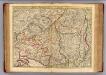
Souabe Meridionale
1 : 240000 L'Isle, Guillaume de, 1675-1726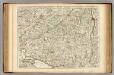
Souabe Meridionale.
1 : 240000 L'Isle, Guillaume de, 1675-1726
Totius S. R. I. Circuli Suevici Tabula Chorographica
1 : 310000 Mollova mapová sbírka Lamsvelt, Jan Ottens, Josua
Pars Sueviae australior
1 : 310000 Württembersko (Německo) Delisle, Guillaume Lotter, Tobias Conrad T. C. Lotter
Nova Rhaetiae atque totius Helvetiae descriptio
1 : 350000 1 Karte auf 10 Bl. per Aegidium Tschudum Glaronensem Hofer & Burger, Zürich
Le Theatre de Bellone :
Mollova mapová sbírka Schenk, Pieter Braakman, Adriaan
Die Lande der Reichs=Erb=Truchsessen zu Waldburg
1 Karte : Kupferdruck ; 22 x 24 cm Reilly F. J. J. von Reilly
Suevia universa IX. tabulis delineata, 6
1 Blatt : s.n.
Constanz - Lindau
1 : 200000 Herder, Benjamin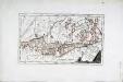
Das Bisthum Augsburg mit der freyen Reichsstadt Augsburg
1 Karte : Kupferdruck ; 31 x 18 cm Reilly F. J. J. von Reilly
Suevia universa IX. tabulis delineata, 9
1 Blatt : s.n.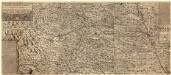
Ilerae Amnis ac Vtrinqve adiacentis Alemanniae Geographica descriptio
1 : 120000 Mollova mapová sbírka Hurter, Johann Christoph Custos, Raphael Hurter, Christoph
Constanz - Lindau : Ulm
Woerl, Joseph Edmund Herder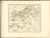

Partie Du Ct. Sentis Et Autriche Anterieure
1 : 120000 Weiss, Johann Heinrich Mayer Johann Rudolf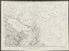
Partie du ct. Sentis et Autriche anterieure
1 : 108000 Weiss, Johann Heinrich ; Guérin, Christophe ; Meyer, Johann Rudolf J. R. Meyer
Topographische Karte der Schweiz
1 : 100000 25 Karten vermessen und hrsg. auf Befehl der Eidgenössischen Behörden ; aufgenommen unter der Aufsicht des Generals G.H. Dufour Eidg. Topographisches Bureau, [Genève], [später: Bern]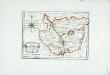
Die gefürstete Abtey Kempten
1 Karte : Kupferdruck ; 19 x 27 cm Reilly F. J. J. von Reilly
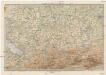
187. Lindau, uit: Topographische Uebersichtskarte des Deutschen Reiches / herausgegeben v. d. Kartogr. Abt. d. Königl. Preuß. Landesaufnahme
1 : 200000 titelvariant: Topogr. Übersichtskarte des Deutschen Reiches; Annotatie: Titel boven bladen ook: Topogr. Übersichtskarte des Deutschen Reiches; Annotatie geografische gegevens: Op elk blad twee maatstokken: 10 Kilometer = 5,5 cm; 1 geogr. Meile = 3,6 cm; Legenda onder op elk blad Königlich Preußische Landesaufnahme. Kartographische Abtheilung [S.l : Königlich Preußische Landesaufnahme, Kartographische Abtheilung]