Maps of Landkreis Oberallgäu

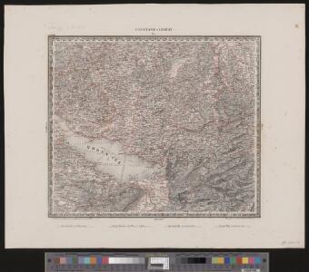
Constanz - Lindau
1 : 200000 1 Karte entworfen und bearbeitet von Woerl ; in Stein gestochen unter seiner Leitung 1834 ; Lithographie von B. Herder Herder, Freiburg im Breisgau
Circulus Suevicus in quo ducatus Wirtenbergensis cum reliquis statibus et provinciis curate designatus propomtur
1 : 640000 Württembersko (Německo) Lotter, Tobias Conrad studio et caelo Tobiae Conradi Lotter
Per Inclyti Circuli Suevici Supremorum Ordinum :
1 : 160000 Mollova mapová sbírka Pfeffel, Johann Andreas Homann, Johann Baptista - dědici
Per Inclyti Circuli Suevici Supremorum Ordinum :
1 : 160000 Mollova mapová sbírka Pfeffel, Johann Andreas Pfeffel, Johann Andreas I.
Nova Rhaetiae atque totius Helvetiae descriptio
1 : 350000 1 Karte auf 10 Bl. per Aegidium Tschudum Glaronensem Hofer & Burger, Zürich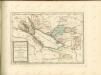

[Exactissima Helvetiae, Rhaetiae, Valesiae ... tabula]
1 : 850000 9 Karten [Kopie von Adrian Braakman] [chez Pierre Schenk et Adrian Braakman], [Amsterdam]
Das Bisthum Costanz, die Grafschaft Montfort
1 Karte : Kupferdruck ; 19 x 27 cm Reilly F. J. J. von Reilly

ALEMANNIA | SIVE | SVEVIA SVPERIOR
A. Christophoro Hurtero. [Amsterdam : Joan Blaeu]
Landtaflen
1 Atlas [von Johannes Stumpf] Christoffel Froschower, Zürych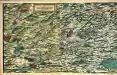
Eigentliche Verzeichnuss der Staetten, Grafschaften und Herschaften welche in der Statt Zuerich Gebiet und Landschaft gehoerig sind, 1
2 Blätter : 46 x 71 cm Conrad Orell und Comp.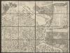
Nova Helvetiae tabula geographica illustrissimis et potentissimis cantonibus et rebuspublicis reformatae religionis Tigurinae, Bernensi, Glaronensi, Basiliensi, Scaphusianae, Abbatis Cellanae
1 : 230000 1 Karte auf 4 Bl. dominis suis clementissimis humillime dicata a Ioh. Iacobo Scheuchzero Tigurino ; Ioh. Melch. Füsslin ornamenta pinx. ; Ioh. Henr. Huber et Eman. Schalch sculps. [Hofmeister], [Zürich]
Schulwandkarte zur Geschichte der Schweiz
1 : 180000 1 Karte auf 6 Bl. bearbeitet v. W. Oechsli u. A. Baldamus ; gezeichnet von Ed. Gaebler Kartograph. Verlagsanstalt von Georg Lang, Leipzig
Kriegs-Schauplatz im Schwabenkrieg bis 20. April 1499
1 : 550000 1 Karte [Feuerwerkergesellschaft], [Zürich]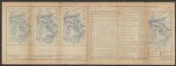
Lacus Constan. XX. Tab. Nova. [Karte], in: Claud. Ptolemaeus. Geographia lat. cum mappis [...], S. 416.
1 Karte aus Atlas Münster, Sebastian [und Ptolemaeus, Claudius]
Lacus Constan. XX. Tab. Nova. [Karte], in: Geographia universalis vetus et nova complectens Claudii Ptolemaei Alexandrini enarrationis libros VIII, S. 356.
1 Karte aus Atlas Münster, Sebastian [und Ptolemaeus, Claudius]
Karte des Bodensees mit Umgebung
1 : 200000 Bodamské jezero (oblast) K. Lindemann
Nova Helvetiae tabula geographica illustrissimis et potentissimis cantonibus et rebuspublicis reformatae religionis Tigurinae, Bernensi, Glaronensi, Basiliensi, Scaphusianae, Abbatis Cellanae
1 : 230000 1 Karte auf 4 Bl. dominis suis clementissimis humillime dicata a Ioh. Iacobo Scheuchzero Tigurino, 1712 ; Ioh. Melch. Füsslin ornamenta pinx. ; Ioh. Henr. Huber et Eman. Schalch sculps. [Hofmeister], [Zürich]
Geographica provinciarum Sueviae descriptio, 6
6 Blätter : Johann Georg Bodenehr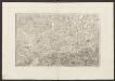
Militair Karte von Süd-Deutschland in 20 Sectionen
1 : 400000 14. Section Coulon, Alois von A. von Coulon
Generalkarte von Württemberg: Blatt IV
1 : 1500000 Terrainzeichnung: Bach, Topograf und Hauptmann Lithografie: Rebmann und Sommer Herausgeber: K. statistisch-topografisches Büro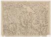
Karte der Kantone Schaffhausen, Zürich, Schwyz, Zug, Unterwalden, Glarus, Appenzell, des Zehngerichtenbunds, der Fürstabtei und der Stadt St. Gallen, der Landgrafschaft Thurgau und weiteren Gebieten der Nordostschweiz
1 : 250000 Originaltitel: Les Cantons de Schafouse, de Zurich, de Schwytz, de Zug, de Underwald, de Glaris, D`Appenzel, les Dix Droitures, L'Abbé et la Ville de St.Gal, Le Thurgow, Les Comtés de Rapperschwil, de Tockenburg, de Werdenberg, de Sargans, Les Balliages de Vtznach, de Gasteren, de Rheinthal, la Baronie d'Alt Sax etc. Ohne Datumsangabe. Jaillot, Alexis-Hubert (1632-1712), Ingenieur und Kartograf, von Frankreich, in Paris (Frankreich)
Totius S. R. I. Circuli Suevici Tabula Chorographica
1 : 310000 Mollova mapová sbírka Lamsvelt, Jan Ottens, Josua
Nouvelle carte de la Suisse, 2
1 Blatt : Covens et Mortier
Nova Helvetiae tabula geographica, 2
1 Blatt : Pieter Schenk
Nova Helvetiae tabula geographica, 2
1 Blatt : Johann Jakob Scheuchzer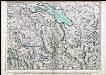
Les Cantons de Schafouse, de Zurich, de Schwytz, de Zug, de Underwald, de Glaris, d'Appenzel, les Dix Droitures, l'Abbé et la Ville de St. Gal, le Thurgow, Les Comtés de Rapperschwil, de Tockenberg, de Werdenberg,...
Jaillot, Alexis Hubert