Maps of Regierungsbezirk Tübingen

Nova Rhaetiae atque totius Helvetiae descriptio
1 : 350000 1 Karte auf 10 Bl. per Aegidium Tschudum Glaronensem Hofer & Burger, Zürich
Circulus Suevicus in quo ducatus Wirtenbergensis cum reliquis statibus et provinciis curate designatus propomtur
1 : 640000 Württembersko (Německo) Lotter, Tobias Conrad studio et caelo Tobiae Conradi Lotter
Constanz - Lindau
1 : 200000 1 Karte entworfen und bearbeitet von Woerl ; in Stein gestochen unter seiner Leitung 1834 ; Lithographie von B. Herder Herder, Freiburg im Breisgau
Karte des Bodensees mit Umgebung
1 : 200000 Bodamské jezero (oblast) K. Lindemann
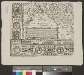
Eigentliche Verzeichnuss der Staetten, Grafschaften und Herschaften welche in der Statt Zuerich Gebiet und Landschaft gehoerig sind, 1
2 Blätter : 46 x 71 cm Conrad Orell und Comp.
Wahre Abconterfethung dess weitberümbten Bodensee, sambt derselben Gelegenheit
1 : 225000 1 Karte [von Johann Georg Tibianus] ; David Seltzel bey Nicolao Kalt, Constanz
Landtaflen
1 Atlas [von Johannes Stumpf] Christoffel Froschower, Zürych
Lacus Constan. XX. Tab. Nova. [Karte], in: Claud. Ptolemaeus. Geographia lat. cum mappis [...], S. 416.
1 Karte aus Atlas Münster, Sebastian [und Ptolemaeus, Claudius]
Lacus Constan. XX. Tab. Nova. [Karte], in: Geographia universalis vetus et nova complectens Claudii Ptolemaei Alexandrini enarrationis libros VIII, S. 356.
1 Karte aus Atlas Münster, Sebastian [und Ptolemaeus, Claudius]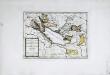
Das Bisthum Costanz, die Grafschaft Montfort
1 Karte : Kupferdruck ; 19 x 27 cm Reilly F. J. J. von Reilly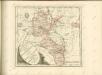
Nova Helvetiae tabula geographica illustrissimis et potentissimis cantonibus et rebuspublicis reformatae religionis Tigurinae, Bernensi, Glaronensi, Basiliensi, Scaphusianae, Abbatis Cellanae
1 : 230000 1 Karte auf 4 Bl. dominis suis clementissimis humillime dicata a Ioh. Iacobo Scheuchzero Tigurino ; Ioh. Melch. Füsslin ornamenta pinx. ; Ioh. Henr. Huber et Eman. Schalch sculps. [Hofmeister], [Zürich]
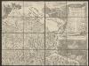
[Exactissima Helvetiae, Rhaetiae, Valesiae ... tabula]
1 : 850000 9 Karten [Kopie von Adrian Braakman] [chez Pierre Schenk et Adrian Braakman], [Amsterdam]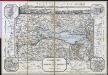
Reisekarte für die Umgebungen des Bodensee's
Baur, C. C. Precht
Nova Helvetiae tabula geographica illustrissimis et potentissimis cantonibus et rebuspublicis reformatae religionis Tigurinae, Bernensi, Glaronensi, Basiliensi, Scaphusianae, Abbatis Cellanae
1 : 230000 1 Karte auf 4 Bl. dominis suis clementissimis humillime dicata a Ioh. Iacobo Scheuchzero Tigurino ; Ioh. Melch. Füsslin ornamenta pinx. ; Ioh. Henr. Huber et Eman. Schalch sculps. [Hofmeister], [Zürich]
Nova Helvetiae tabula geographica illustrissimis et potentissimis cantonibus et rebuspublicis reformatae religionis Tigurinae, Bernensi, Glaronensi, Basiliensi, Scaphusianae, Abbatis Cellanae
1 : 230000 1 Karte auf 4 Bl. dominis suis clementissimis humillime dicata a Ioh. Iacobo Scheuchzero Tigurino, 1712 ; Ioh. Melch. Füsslin ornamenta pinx. ; Ioh. Henr. Huber et Eman. Schalch sculps. [Hofmeister], [Zürich]
Generalkarte von Württemberg: Blatt IV
1 : 1500000 Terrainzeichnung: Bach, Topograf und Hauptmann Lithografie: Rebmann und Sommer Herausgeber: K. statistisch-topografisches Büro
<<Das>> Turgow
1 : 410000 1 Karte [Johannes Stumpf] [Froschauer], [Zürich]
Militair Karte von Süd-Deutschland in 20 Sectionen
1 : 400000 14. Section Coulon, Alois von A. von Coulon
Atlas der alten Eidgenossenschaft in 20 Karten: Landgrafschaft Thurgau
Originaltitel: La Turgovie avec le Lac de Constance et des Pays circonvoisins. Mit Erklärung der Zeichen sowie Zeichnung des Rheinfalls. Zeichnung: Rizzi Zannoni, Joh. Ant., Professor der Mathematik und Geografie Herausgeber: Homännische Erben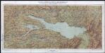
Karte von Bodensee, Rhein und Bregenzerwald : mit den angrenzenden Gebieten von Baden, Württemberg, Bayern, Österreich und der Schweiz
Becker, Fridolin Kümmerly und Frey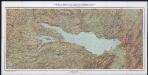
Karte von Bodensee, Rhein und Bregenzerwald : mit den angrenzenden Gebieten von Baden, Württemberg, Bayern, Österreich und der Schweiz
Becker, Fridolin Kümmerly und Frey
Partie du Ct. Sentis et Autriche anterieure.
From Atlas Suisse. Levé et dessiné par J. H. Weiss aux fraix de J. R. Meyer á Aarau dans les années 1786 á 1802. Gravée par Guerin, Eichler, et Scheurmann.
Constanz - Lindau : Ulm
Woerl, Joseph Edmund Herder
Constanz - Lindau
1 : 200000 Herder, Benjamin
Lacus Bodamicus vel Acronius
1 Karte : Kupferdruck ; 46 x 54 cm Probst; Seutter anjezo in Verlag bey Ioh. Michael Probst Chalc
Lacus Bodamicus vel Acronius
1 Karte : Kupferdruck ; 46 x 54 cm Probst; Seutter anjezo in Verlag bey Ioh. Michael Probst Chalc
Lacus Bodamicus vel Acronius
1 Karte : Kupferdruck ; 46 x 54 cm Probst; Seutter anjezo in Verlag bey Ioh. Michael Probst Chalc