Maps of Thurgau
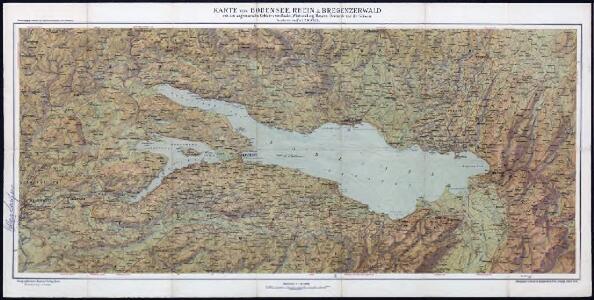
Karte von Bodensee, Rhein und Bregenzerwald : mit den angrenzenden Gebieten von Baden, Württemberg, Bayern, Österreich und der Schweiz
Becker, Fridolin Kümmerly und Frey
Karte von Bodensee, Rhein und Bregenzerwald : mit den angrenzenden Gebieten von Baden, Württemberg, Bayern, Österreich und der Schweiz
Becker, Fridolin Kümmerly und Frey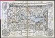
Reisekarte für die Umgebungen des Bodensee's
Baur, C. C. Precht
Wahre Abconterfethung dess weitberümbten Bodensee, sambt derselben Gelegenheit
1 : 225000 1 Karte [von Johann Georg Tibianus] ; David Seltzel bey Nicolao Kalt, Constanz
Lacus Bodamicus vel Acronius
1 Karte : Kupferdruck ; 46 x 54 cm Probst; Seutter anjezo in Verlag bey Ioh. Michael Probst Chalc
Lacus Bodamicus vel Acronius
1 Karte : Kupferdruck ; 46 x 54 cm Probst; Seutter anjezo in Verlag bey Ioh. Michael Probst Chalc
Lacus Bodamicus vel Acronius
1 Karte : Kupferdruck ; 46 x 54 cm Probst; Seutter anjezo in Verlag bey Ioh. Michael Probst Chalc
Lacus Bodamicus vel Acronius
1 Karte : Kupferdruck ; 47 x 55 cm Seutter Matthäus Seutter
Lacus Constan. XX. Tab. Nova. [Karte], in: Claud. Ptolemaeus. Geographia lat. cum mappis [...], S. 416.
1 Karte aus Atlas Münster, Sebastian [und Ptolemaeus, Claudius]
Lacus Constan. XX. Tab. Nova. [Karte], in: Geographia universalis vetus et nova complectens Claudii Ptolemaei Alexandrini enarrationis libros VIII, S. 356.
1 Karte aus Atlas Münster, Sebastian [und Ptolemaeus, Claudius]
Karte des Bodensees mit Umgebung
1 : 200000 Bodamské jezero (oblast) K. Lindemann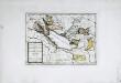
Das Bisthum Costanz, die Grafschaft Montfort
1 Karte : Kupferdruck ; 19 x 27 cm Reilly F. J. J. von Reilly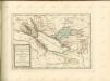

Lacus Bodamicus vel Acronius cum regionibus circumiacentibus
Seutter, Matthäus Probst
Frauenfeld, St. Gallen
1 : 100000 1 Karte von F. Schalch, A. Gutzwiller, J. Schill [Wurster & Randegger], [Winterthur]
Topographische Karte der Schweiz (Dufour-Karte): Den Kanton Zürich betreffende Blätter: Blatt IV: Frauenfeld, St. Gallen
1 : 100000 Leitung: Dufour, Guillaume-Henri (1787-1875), General, Politiker, Ingenieur und Kartograf, von Genf; Eidgenössisches Topographisches Bureau, in Genf Stich: Bachofen, Johann Heinrich, andere Schreibweise: Jean-Henri, (1821-1889), Zeichner, Maler, Architekt und Topograf, von Uster; Bressanini, Rinaldo (1803-1864), Kupferstecher und Kartograf, von Italien; Müllhaupt, Heinrich (1820-1894), Kupferstecher und Kartograf, von Hofstetten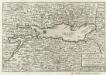
Bodensee alias Lacus Bodamicus Acronius, Brigantinus
1 : 270000 Mollova mapová sbírka Person, Nikolaus Person, Nicolas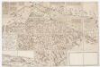
Karte der Landgrafschaft Thurgau samt angrenzenden Herrschaften
1 : 52000 Vereinfachte handgezeichnete Kopie der im Jahr 1628 von Johannes Murer (1556-1641), Pfarrer in Rickenbach und Dekan des Winterthurer Pfarrkapitels, sowie Hans Caspar Huber, früherer Landvogt der Herrschaft Pfyn, in Auftrag gegebenen und von Hans Conrad Gyger (1599-1674), Kartograf und Ingenieur, von Zürich, verfertigten Originalkarte. Mit Legenden und biografischen Angaben über Johannes Murer, mit Wappen der regierenden Orte sowie mit Ansicht von Frauenfeld. Wagner, Johann Jakob (1641-1695), Stadtarzt von Zürich und naturwissenschaftlicher Forscher, von Zürich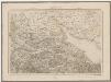
Topographische Karte der Schweiz (Dufour-Karte): Den Kanton Zürich betreffende Blätter: Blatt IV: Frauenfeld, St. Gallen
1 : 100000 Leitung: Dufour, Guillaume-Henri (1787-1875), General, Politiker, Ingenieur und Kartograf, von Genf; Eidgenössisches Topographisches Bureau, in Genf Stich: Bachofen, Johann Heinrich, andere Schreibweise: Jean-Henri, (1821-1889), Zeichner, Maler, Architekt und Topograf, von Uster; Bressanini, Rinaldo (1803-1864), Kupferstecher und Kartograf, von Italien; Müllhaupt, Heinrich (1820-1894), Kupferstecher und Kartograf, von Hofstetten; Stempelmann, J. (1835-1887) Druck: Koegel, Henri (1816-1867)
Lacus Bodamicus vel Acronius cum regionibus circumjacentibus recens delineatus
1 : 170000 Mollova mapová sbírka Seutter, Matthäus Seutter, Matthäus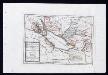
Das Bisthum Constanz, die Grafschaft Montfort oder die Herrschaften Tetnang und Argen, die Grafschaften Hohenembs, Vadutz und Schellenberg mit den freyen Reichsstädten Ueberlingen, Wangen, Lindau und Buchhorn : Nro. 196
Reilly, Franz Johann Joseph von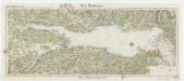
[Kaart], uit: Der Bodensee
1 : 100000 Annotatie: Verso: toeristische informatie Stuttgart : Von Paasche & Luz
Suevia universa IX. tabulis delineata, 8
1 Blatt : s.n.
Topographische Karte der Schweiz
1 : 100000 25 Karten vermessen und hrsg. auf Befehl der Eidgenössischen Behörden ; aufgenommen unter der Aufsicht des Generals G.H. Dufour Eidg. Topographisches Bureau, [Genève], [später: Bern]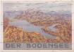
Der Bodensee
Bodamské jezero (oblast) M. Wittkop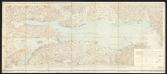
Bodenseekarte
1 : 50000 Schweiz Eidgenössisches Topographisches Bureau Eidg. Topogr. Büreau
Constanz - Lindau : Ulm
Woerl, Joseph Edmund Herder
Projektierte Eisenbahnstrecke Winterthur-Singen-Kreuzlingen; Übersichtskarte
1 : 250000 Mit Legende. Ohne Datumsangabe. Wurster, Randegger und Cie., in Winterthur
Carte des Cantons Thurgau
1 : 150000 1 Karte trigonometrische Aufnahme [Johann Jakob] Sulzberger ; [Rinaldo] Bressanini sc. bey Heinr. Fuessli & Co., Zürich