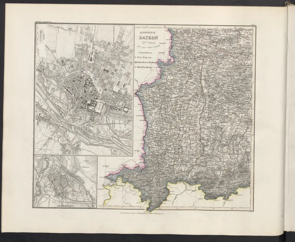
Maps of Landkreis Ostallgäu

Maps of Landkreis Ostallgäu

$title$

$title$

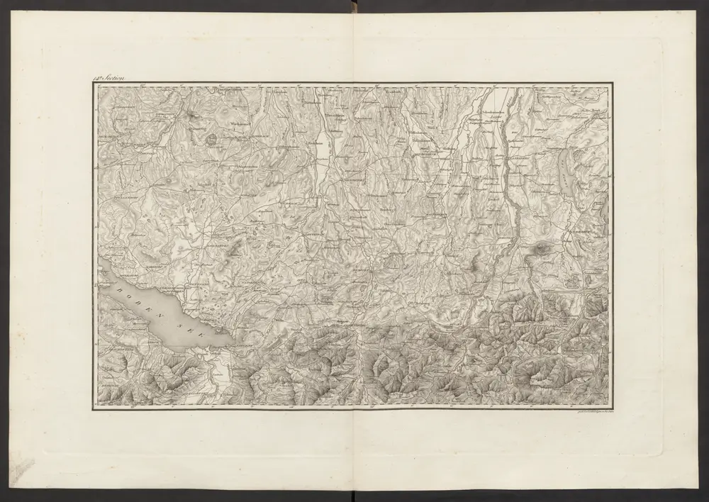
Militair Karte von Süd-Deutschland in 20 Sectionen

1 : 400000 14. Section Coulon, Alois von A. von Coulon
$title$

Circulus Suevicus in quo ducatus Wirtenbergensis cum reliquis statibus et provinciis curate designatus propomtur

1 : 640000 Württembersko (Německo) Lotter, Tobias Conrad studio et caelo Tobiae Conradi Lotter
$title$

Karte der Bayrischen und Algäuer Alpen

1 : 250000 Allgäuské Alpy (Německo a Rakousko) Ravenstein, Ludwig L. Ravenstein
$title$

Alemannia sive Suevia Superior

Hurter, Christoph
$title$

Nova Alemanniae sive Sveviae Svperioris Tabvla

Hondius, Henricus
$title$

ALEMANNIA | SIVE | SVEVIA SVPERIOR

A. Christophoro Hurtero. [Amsterdam : Joan Blaeu]
$title$

[Exactissima Helvetiae, Rhaetiae, Valesiae ... tabula]

1 : 850000 9 Karten [Kopie von Adrian Braakman] [chez Pierre Schenk et Adrian Braakman], [Amsterdam]
$title$

Alemannia sive Svevia Svperior

1 : 480000 Mollova mapová sbírka Hurter, Johann Christoph Blaeu, Joan I.
$title$

Nova Alemanniae sive Svevia Svperioris Tabvla

1 : 490000 Mollova mapová sbírka Hurter, Johann Christoph Janssonius, Johannes I
$title$

Alemaniae sive Sveviae Svperioris Chorographia nova

1 : 310000 Mollova mapová sbírka Hurter, Johann Christoph Custos, Raphael
$title$

Geographica provinciarum Sueviae descriptio, 6

6 Blätter : Johann Georg Bodenehr
$title$

Totius s.r.i. circuli Suevici tabula chorographica, 4

1 Blatt : R. et J. Ottens
$title$

Constanz - Lindau

1 : 200000 1 Karte entworfen und bearbeitet von Woerl ; in Stein gestochen unter seiner Leitung 1834 ; Lithographie von B. Herder Herder, Freiburg im Breisgau
$title$

Carte topographique d'Allemagne contenant une partie de Bavére, de Suabe, du comté de Tirol et de l'évêché d'Augspourg, l'Algow, les quatre seigneuries autrichienne devant la montagne d'Arlenberg

1 Karte fait par I. W. Iaeger chez l'auteur, Francfort sur le Mein
$title$

Partie meridionale de la Souabe

1 Karte : Kupferdruck ; 46 x 65 cm L'Isle; Ottens; Ottens chez R. et I. Ottens geogr
$title$

Nova Rhaetiae atque totius Helvetiae descriptio

1 : 350000 1 Karte auf 10 Bl. per Aegidium Tschudum Glaronensem Hofer & Burger, Zürich
$title$

Partie septentrionale de la Souabe

1 : 280000 par Guillaume De L'Isle A Amsterdam : chez J. Covens et C. Mortier
$title$

Pars Sueviae Australior

1 : 250000 Mollova mapová sbírka Delisle, Guillaume Wolff, Jeremias
$title$

Pars Sueviæ australior

1 Karte : Kupferdruck ; 46 x 61 cm L'Isle; Lotter apud Tobiam Conradum Lotter calcogr
$title$

Partie meridionale de la Souabe

1 Karte : Kupferdruck ; 46 x 62 cm L'Isle; Renard chez l'auteur sur le quai de l'Horloge, chez L. Renard libraire prez de la bourse
$title$

Souabe Meridionale

1 : 240000 L'Isle, Guillaume de, 1675-1726
$title$

Souabe Meridionale.

1 : 240000 L'Isle, Guillaume de, 1675-1726
$title$

Schulwandkarte zur Geschichte der Schweiz

1 : 180000 1 Karte auf 6 Bl. bearbeitet v. W. Oechsli u. A. Baldamus ; gezeichnet von Ed. Gaebler Kartograph. Verlagsanstalt von Georg Lang, Leipzig
$title$

Totius S. R. I. Circuli Suevici Tabula Chorographica

1 : 310000 Mollova mapová sbírka Lamsvelt, Jan Ottens, Josua
$title$

Generalkarte von Württemberg: Blatt IV

1 : 1500000 Terrainzeichnung: Bach, Topograf und Hauptmann Lithografie: Rebmann und Sommer Herausgeber: K. statistisch-topografisches Büro
$title$

Carte topographique d'Allemagne contenant une partie de Baviére de Suabe du comté de Tirol et de l'eveché d'Augspourg

1 Karte : Kupferdruck ; 45 x 64 cm Jaeger; Facius se vend chez l'auteur
$title$

Pars Sueviae australior

1 : 310000 Württembersko (Německo) Delisle, Guillaume Lotter, Tobias Conrad T. C. Lotter
$title$

Der Lech-Fluss von Füessen im Algöw an, bis zu seinen Auslauff in die Donaw

Německo Bodenehr, Gabriel G. Bodenehr
$title$

Suevia universa IX. tabulis delineata, 9

1 Blatt : s.n.
© MapTiler © OpenStreetMap contributors
How does it work?
These instructions will show you how to find historical maps online.
Getting started
Type the place name in the search box to find the exact location. You can further adjust the search by zooming in and out.
Zoom
Zoom in and out with the buttons or use your mouse or touchpad natively.
Exact Area tool
Click here and draw a rectangle over the map to precisely define the search area.
Set filters
Narrow your search with advanced settings, such as Years (from/to), Fulltext, Publisher, etc.
Results
See the results of your search on the right side. You can scroll down to find more maps of this location.
?

Download OldMapsOnline Mobile