Maps of Landkreis Ravensburg

Maps of Landkreis Ravensburg

$title$

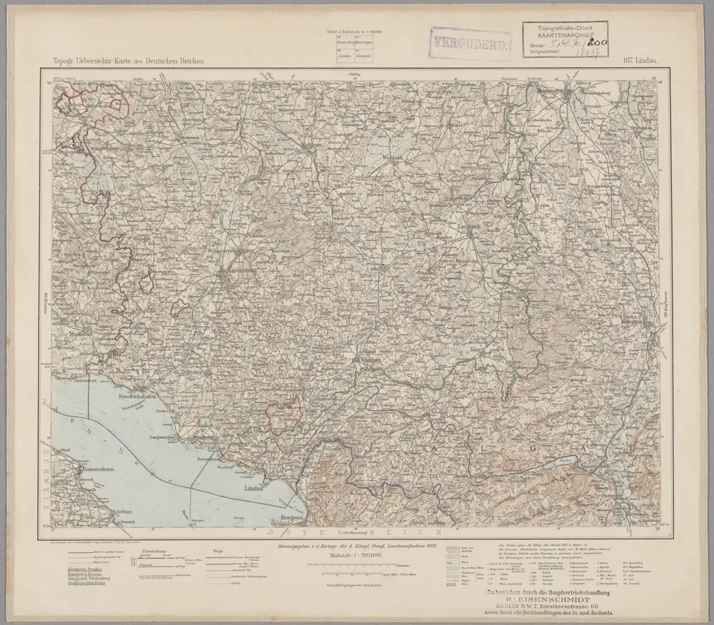
187. Lindau, uit: Topographische Uebersichtskarte des Deutschen Reiches / herausgegeben v. d. Kartogr. Abt. d. Königl. Preuß. Landesaufnahme

1 : 200000 titelvariant: Topogr. Übersichtskarte des Deutschen Reiches; Annotatie: Titel boven bladen ook: Topogr. Übersichtskarte des Deutschen Reiches; Annotatie geografische gegevens: Op elk blad twee maatstokken: 10 Kilometer = 5,5 cm; 1 geogr. Meile = 3,6 cm; Legenda onder op elk blad Königlich Preußische Landesaufnahme. Kartographische Abtheilung [S.l : Königlich Preußische Landesaufnahme, Kartographische Abtheilung]
$title$

Constanz - Lindau

1 : 200000 Herder, Benjamin
$title$

Partie Du Ct. Sentis Et Autriche Anterieure

1 : 120000 Weiss, Johann Heinrich Mayer Johann Rudolf
$title$

Geographica Provinciarum Sveviae Descriptio =

Mollova mapová sbírka Hurter, Johann Christoph Bodenehr, Gabriel
$title$

[Landvogdey in Schwaben]

Bodenehr, Johann Georg
$title$

Geographica Provinciarum Sveviae Descriptio =

Mollova mapová sbírka Hurter, Johann Christoph Bodenehr, Johann Georg
$title$

Comitatvs Tetnang Illustr. Comitum de Montfort, et confinia

1 : 120000 Mollova mapová sbírka Merian, Matthaeus Merian, Matthäus
$title$

Topographische Karte der Schweiz (Dufour-Karte): Den Kanton Zürich betreffende Blätter: Blatt V: Rheineck; Verzeichnis von Ortsbenennungen in verschiedenen Sprachen, Zeichen und Abkürzungen

1 : 100000 Leitung: Dufour, Guillaume-Henri (1787-1875), General, Politiker, Ingenieur und Kartograf, von Genf; Eidgenössisches Topographisches Bureau, in Genf Stich: Bressanini, Rinaldo (1803-1864), Kupferstecher und Kartograf, von Italien; Müllhaupt, Heinrich (1820-1894), Kupferstecher und Kartograf, von Hofstetten; Werdmüller, Johann Conrad (1826-1849), Kupferstecher, in Genf
$title$

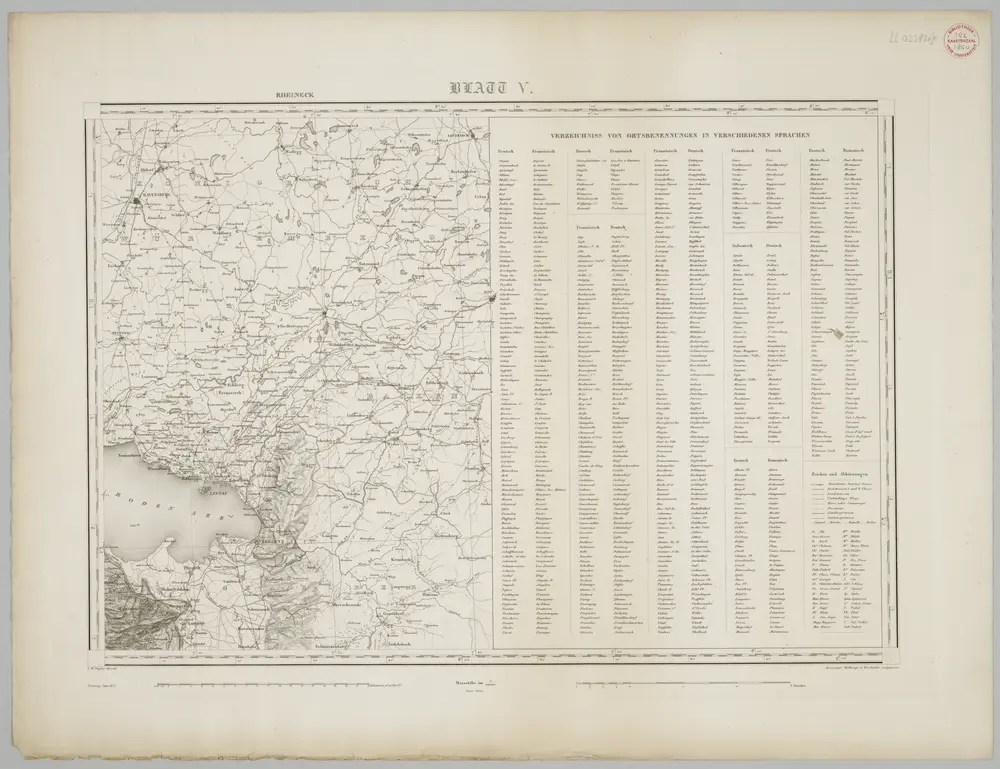
Blatt V: Rheineck, Verzeichniss von Ortsbenennungen in verschiedenen Sprachen, uit: Topographische Karte der Schweiz / vermessen und hrsg. ... unter Aufsicht des Generals G.H. Dufour

1 : 100000 Annotatie: Met plaatsnamenregister (bl. V), bladwijzer (bl. XXI) en hoogteregister (bl. XXV); Voor aanwezige bladen zie overzichtsblad Dufour, G. H. [Bern : Eidg. Topogr. Bureau]
$title$

Boden-See

1 : 75000 Kartograph., früher Militärgeograph. Inst.
$title$

Isny und Immenstadt.

from Spezialkarte der osterreichisch-ungarischen Monarchie.
$title$

Bodensee.

from Spezialkarte der osterreichisch-ungarischen Monarchie.
$title$

Wolfeck, Wurtzach, Zeyl a okolí]

Mollova mapová sbírka Bodenehr, Gabriel Bodenehr, Gabriel
$title$

Veriungter Abriss des Heyl. Reichs Statt Lindaw, vnd derselben theils Allieglicher, theils allein Nidergerichtlicher Oberkeit aus der

Mollova mapová sbírka Rauch, Johann Andreas
$title$

Veriungter Abriss des Heyl. Reichs Statt Lindaw, vnd derselben theils Allieglicher, theils allein Nidergerichtlicher Oberkeit aus der

Mollova mapová sbírka Rauch, Johann Andreas
$title$

Veriungter Abriss Deß Heyl. Reichs Statt Lindaw, vnd derselben theils Alliglicher, theils allein Nidergerichtlicher Oberkeit

Mollova mapová sbírka Rauch, Johann Andreas
$title$

Veriungter Abriss des Heyl. Reichs Statt Lindaw, vnd derselben theils Alliglicher, theils allein Nidergerichtlicher Oberkeit aus der

Mollova mapová sbírka Rauch, Johann Andreas
$title$

Meßtischblatt [8423] : Langenargen, 1893

1 : 250000 Langenargen. - 1:25000. - Stuttgart, 1893. - 1 Kt.
$title$

Meßtischblatt [8326] : Isny, 1920

1 : 250000 Isny. - 1:25000. - Stuttgart, 1920. - 1 Kt.
$title$

Meßtischblatt [8325] : Wangen, 1920

1 : 250000 Wangen. - 1:25000. - Stuttgart, 1920. - 1 Kt.
$title$

Meßtischblatt [8324] : Neukirch (Württ.), Achberg (Preuß.), 1911

1 : 250000 Neukirch (Württ.), Achberg (Preuß.). - Hrsg. 1895, 2. Ausg., 1911. - 1:25000. - Stuttgart, 1911. - 1 Kt.
$title$

Meßtischblatt [8323] : Tettnang, 1908

1 : 250000 Tettnang. - 1:25000. - Stuttgart, 1908. - 1 Kt.
$title$

Meßtischblatt [8322] : Friedrichshafen, 1905

1 : 250000 Friedrichshafen. - 2. Ausg. - 1:25000. - Stuttgart, 1905. - 1 Kt.
$title$

Meßtischblatt [8322] : Immenstaad, 1880

1 : 250000 Immenstaad. - [Ausg.] 1879 u. 1880. - 1:25000. - Leipzig: Giesecke & Devrient, 1880. - 1 Kt.
$title$

Meßtischblatt [8226] : Herlazhofen, 1921

1 : 250000 Herlazhofen. - 1:25000. - Stuttgart, 1921. - 1 Kt.
$title$

Meßtischblatt [8225] : Kisslegg, 1907

1 : 250000 Kisslegg. - 1:25000. - Stuttgart, 1907. - 1 Kt.
$title$

Meßtischblatt [8224] : Waldburg, 1908

1 : 250000 Waldburg. - 1:25000. - Stuttgart, 1908. - 1 Kt.
$title$

Meßtischblatt [8223] : Ravensburg, 1908

1 : 250000 Ravensburg. - 1:25000. - Stuttgart, 1908. - 1 Kt.
$title$

Meßtischblatt [8222] : Markdorf, Adelsreuthe, 1883

1 : 250000 Markdorf, Adelsreuthe. - [Ausg.] 1880 u. 1883. - 1:25000. - Leipzig: Giesecke & Devrient, 1883. - 2 Kt. auf 1 Bl.
$title$

Meßtischblatt 174 : Oberteuringen, 1907

1 : 250000 Oberteuringen. - 1:25000. - Stuttgart, 1877. - 1 Kt.
© MapTiler © OpenStreetMap contributors
How does it work?
These instructions will show you how to find historical maps online.
Getting started
Type the place name in the search box to find the exact location. You can further adjust the search by zooming in and out.
Zoom
Zoom in and out with the buttons or use your mouse or touchpad natively.
Exact Area tool
Click here and draw a rectangle over the map to precisely define the search area.
Set filters
Narrow your search with advanced settings, such as Years (from/to), Fulltext, Publisher, etc.
Results
See the results of your search on the right side. You can scroll down to find more maps of this location.
?

Download OldMapsOnline Mobile