Maps of Landkreis Oberallgäu

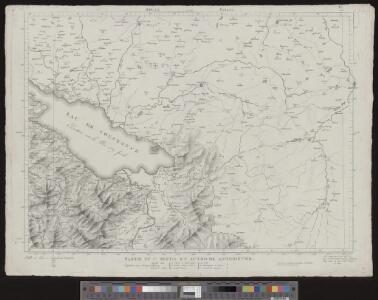
Atlas Suisse
1 : 120000 16 Karten levé et dessiné par J.H. Weiss [et Joachim Eugen Müller] aux frais de J.R. Meyer à Aarau dans les années 1786 à 1802 ; gravée [sic] par [Christophe] Guérin, [Matthias Gottfried] Eichler et [Johann Jakob] Scheurmann [Johann Rudolf Meyer], Aarau
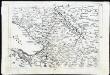
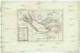
Partie du Ct. Sentis et Autriche anterieure.
From Atlas Suisse. Levé et dessiné par J. H. Weiss aux fraix de J. R. Meyer á Aarau dans les années 1786 á 1802. Gravée par Guerin, Eichler, et Scheurmann.
Partie du ct. Sentis et Autriche anterieure
1 : 108000 Weiss, Johann Heinrich ; Guérin, Christophe ; Meyer, Johann Rudolf J. R. Meyer
Partie Du Ct. Sentis Et Autriche Anterieure
1 : 120000 Weiss, Johann Heinrich Mayer Johann Rudolf
Bregensz 156, uit: Special-Karte von Mittel-Europa / nach amtlichen Quellen bearbeitet von W. Liebenow
1 : 300000 titelvariant: W. Liebenow's Mittel-Europa; Annotatie: Titel boven de bladen: W. Liebenow's Mittel-Europa Johannes Wilhelm Liebenow 1822-1897 Frankfurt a. M. : Ludwig Ravenstein
Bregensz 156, uit: [W. Liebenow's Special-Karte von Mittel-Europa]
1 : 300000 titelvariant: W. Liebenow's Mittel-Europa; Annotatie: Titel boven de bladen: W. Liebenow's Mittel-Europa Johannes Wilhelm Liebenow 1822-1897 Hannover : Hermann Oppermann
Constanz - Lindau : Ulm
Woerl, Joseph Edmund Herder
Constanz - Lindau
1 : 200000 Herder, Benjamin
Topographische Karte der Schweiz
1 : 100000 25 Karten vermessen und hrsg. auf Befehl der Eidgenössischen Behörden ; aufgenommen unter der Aufsicht des Generals G.H. Dufour Eidg. Topographisches Bureau, [Genève], [später: Bern]
Vorarlberg
1 : 165000 Lichtenštejnsko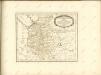
Das Bisthum Costanz, die Grafschaft Montfort oder die Herrschaften Tetnang und Argen die Grafschaften Hohenembs, Vadutz und Schellenberg mit den freyen Reichsstädten Ueberlingen, Wangen, Lindau, und Buchhorn
1 : 380000 Bodamské jezero-oblast
Die Lande der Reichs=Erb=Truchsessen zu Waldburg
1 Karte : Kupferdruck ; 22 x 24 cm Reilly F. J. J. von Reilly
Suevia Universa :
1 : 170000 Mollova mapová sbírka Michal, Jacques de Seutter, Matthäus Seutter, Matthäus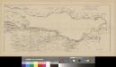
Situation der Linie Constanz - Romanshorn - Rorschach
1 : 100000 1 Karte [Kartogr.:] Topogr. Anst. v. Wurster, Randegger & Cie. in Winterthur Schweizerische Nordostbahn, [Erscheinungsort nicht ermittelbar]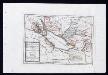
Das Bisthum Constanz, die Grafschaft Montfort oder die Herrschaften Tetnang und Argen, die Grafschaften Hohenembs, Vadutz und Schellenberg mit den freyen Reichsstädten Ueberlingen, Wangen, Lindau und Buchhorn : Nro. 196
Reilly, Franz Johann Joseph von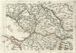
Geographica Provinciarum Sveviae Descriptio =
Mollova mapová sbírka Hurter, Johann Christoph Bodenehr, Gabriel
Lacus Bodamicus vel Acronius
1 Karte : Kupferdruck ; 46 x 54 cm Probst; Seutter anjezo in Verlag bey Ioh. Michael Probst Chalc
Lacus Bodamicus vel Acronius
1 Karte : Kupferdruck ; 46 x 54 cm Probst; Seutter anjezo in Verlag bey Ioh. Michael Probst Chalc
Lacus Bodamicus vel Acronius
1 Karte : Kupferdruck ; 46 x 54 cm Probst; Seutter anjezo in Verlag bey Ioh. Michael Probst Chalc
Lacus Bodamicus vel Acronius
1 Karte : Kupferdruck ; 47 x 55 cm Seutter Matthäus Seutter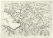
Geographica Provinciarum Sveviae Descriptio =
Mollova mapová sbírka Hurter, Johann Christoph Bodenehr, Johann Georg
<<Der>> Boden-See
1 Vogelschaukarte Orell Füssli, Zürich
Charte von Vorarlberg
Diewald, Johann Nepomuk Homann
Lacus Bodamicus vel Acronius cum regionibus circumiacentibus
Seutter, Matthäus Probst
Bodenseekarte
1 : 50000 Ost-Blatt Eidgenössisches Topographisches Bureau Eidg. Topogr. Büreau
187. Lindau, uit: Topographische Uebersichtskarte des Deutschen Reiches / herausgegeben v. d. Kartogr. Abt. d. Königl. Preuß. Landesaufnahme
1 : 200000 titelvariant: Topogr. Übersichtskarte des Deutschen Reiches; Annotatie: Titel boven bladen ook: Topogr. Übersichtskarte des Deutschen Reiches; Annotatie geografische gegevens: Op elk blad twee maatstokken: 10 Kilometer = 5,5 cm; 1 geogr. Meile = 3,6 cm; Legenda onder op elk blad Königlich Preußische Landesaufnahme. Kartographische Abtheilung [S.l : Königlich Preußische Landesaufnahme, Kartographische Abtheilung]
Isny und Immenstadt.
from Spezialkarte der osterreichisch-ungarischen Monarchie.
Bodensee.
from Spezialkarte der osterreichisch-ungarischen Monarchie.