Maps of Greater Poland

Brandenburg, Schlesien, Posen
Neuer Handatlas über alle Theile der Erde Kiepert, Heinrich Verlag von Dietrich Reimer
Mitteldeutschland
Volksschul-Atlas über alle Teile der Erde Lange, Henry Druck und Verlag von Georg Westermann
Říše česká za Karla IV.

Operations Karte im Jahr 1759 ...

Die Königl. Preussischen Provinzen Brandenburg Pommern Sachsen und Schlesien nebst Mecklenburg
Mitteleuropa
Le Cours de l'Elbe et de l'Oder où sont les Electorats de Saxe et de Brandebourg, les Duchés de Mekelbourg et de Pomeranie
1 : 1400000 Mollova mapová sbírka Duval, Pierre Duval, Pierre
Upper Saxony, Silesia, Lusatia.
1 : 1340000 Cary, John, ca. 1754-1835
Nordöstliches Deutschland
Preußen
Upper Saxony.
1 : 1500000 Lizars, Daniel
L'Empire, d'Allemagne
1 : 1200000 Mollova mapová sbírka Sanson, Nicolas Quasy, Robert
Oder
Oder, Flusslauf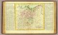
Haute Saxe.
1 : 1900000 Clouet, J. B. L. (Jean-Baptiste Louis), b. 1730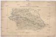
Karte vom nördlichen Kriegsschauplatze
Prusko Jacob Dirnböck
Karte von Deutschland in IV Blättern
1 : 825000 Nordost-Blatt Sotzmann, Daniel Friedrich im Verlage der A. G. Schneider und Weigels
Upper Saxony.
1 : 2900000 Bowen, Frances
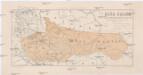
Odra
1 : 2400000 Odra-povodí Zeměměřický úřad
The eastern front
1 : 2280000 Shows railways, main highways, and the Front as of Feb. 12-19 (1945.). "Restricted." "No. 6180 - R & A, OSS. 20 February 1945." United States. Office of Strategic Services. Research and Analysis Branch. [Washington, D.C.] : Lithographed in Reproduction Branch, OSS
Il Regno di Boemia la Slesia Prussiana ed Austriaca noc li Marchesati di Muravia e Lusazia

Mapa království českého
1 : 1000000
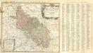
Schlesien, Posen, Odergebiet
1 : 2250000 Schlesien, Provinz Posen, Skizzenbuch
A map of Bohemia, Moravia, Silesia, Lussatia, with great part of Saxony & Brandenburg, shewing the present seat of war, in Germany
1 : 1970000 Braniborsko (Německo)
Ietziges Kriegs Theatrum in Sachsen, Böhmen, u. Schlesien
Říše česká za knížete Boleslava II. okolo r. 973
1 : 2600000 Česko Kalousek, Josef Brož, Josef nákladem Františka Řivnáče
Regni Bohemiae, Duc. Silesiae, Marchionatuum Moraviae et Lusatiae...
Ducatus Silesiae Tabula geographica generalis statui hodierno, ei nempe qui post pacem Dresdensem locum obtinet =
1 : 870000 Mollova mapová sbírka Mayer, Tobias Homann, Johann Baptista - dědici
Dvcatvs Silesiae Tabula geographica generalis
1 : 870000 Mollova mapová sbírka Mayer, Tobias Homann, Johann Baptista - dědici
Belgium distributum in septemdecem Provincias Artesiam, Flandriam, Hanoviam, Luceburgium, Geldriam, Brabantiam, Hollandiam. Zelandiam, Transisulaniam, Frisiam, Groningam, etc. quibus accedunt Episcop Leodiensis, cum ulterioribus Regionibus, Venundantur â
1 : 840000 Mollova mapová sbírka Valck, Leonardus Valck, Gerard
The routs of the Prussian armies into Bohemia with the post roads and distances
1 : 2200000 Evropa střední Jefferys, Thomas T. Jefferys
Brandenburg, Posen.
1 : 1350000 Andree, Richard


