Maps of Greater Poland Voivodeship

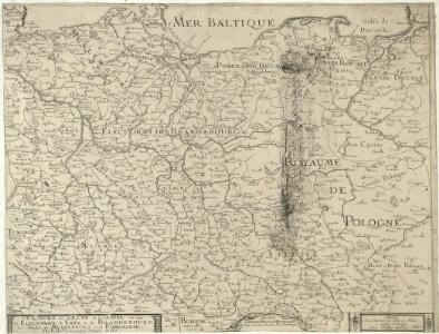
Le Cours de l'Elbe et de l'Oder où sont les Electorats de Saxe et de Brandebourg, les Duchés de Mekelbourg et de Pomeranie
1 : 1400000 Mollova mapová sbírka Duval, Pierre Duval, Pierre
The N. E. Part of Germany
1 : 3400000 Mollova mapová sbírka Moll, Herman Moll, Hermann
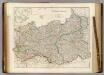
Die Königl. Preussischen Provinzen Brandenburg Pommern Sachsen und Schlesien nebst Mecklenburg
Mitteleuropa
[Nordöstliches Deutschland]
Schul-Atlas über alle Theile der Erde nach dem neuesten Zustande, und über das Weltgebäude Stieler, Adolf bei Justus Perthes
Operations Karte im Jahr 1759 ...

NE pt. of Germany.
1 : 3150000 Bowen, Emanuel
NO Deutschland.
1 : 5500000 Brudin, J. L.; Stieler, Adolf
The N.E. part of Germany.
1 : 3500000 Moll, Herman, d. 1732
L'Empire, d'Allemagne
1 : 1200000 Mollova mapová sbírka Sanson, Nicolas Quasy, Robert
Upper Saxony.
1 : 2900000 Bowen, Frances
Prussia, Poland.
1 : 1570000 Arrowsmith, John
Germany No.1, Prussia and Saxony.
1 : 2500000 Colton, G.W.
Nordöstliches Deutschland
Preußen
Prussia.
1 : 3400000 Finley, Anthony
Prussia and Saxony.
1 : 3000000 Colton, G.W.
Prussia.
1 : 3400000 Finley, Anthony
Prussia.
1 : 3300000 Tanner, Henry S.
Prussia & Poland.
1 : 1584000 Arrowsmith, John
Prussia.
1 : 2650000 Hughes, William
Generale-Charte der Preussischen Monarchie in zwey Blättern
1 : 1030000 Prusko Streit, Friedrich Wilhelm Gilly Geograph. Institut
Prussia and Saxony.
1 : 3000000 Colton, G.W.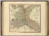
Upper Saxony, Silesia, Lusatia.
1 : 1340000 Cary, John, ca. 1754-1835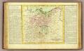
Haute Saxe.
1 : 1900000 Clouet, J. B. L. (Jean-Baptiste Louis), b. 1730
Mitteldeutschland
Volksschul-Atlas über alle Teile der Erde Lange, Henry Druck und Verlag von Georg Westermann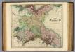
Upper Saxony.
1 : 1500000 Lizars, Daniel
Europe Centrale (Partie Centrale).
1 : 1750000 Jouvet et Cie.
[Nord-Östliches Deutschland]
Hand-Atlas über alle Theile der Erde nach dem neuesten Zustande und über das Weltgebäude Stieler, Adolf bei Justus Perthes
Nord-östliches Deutschland
1 : 1850000 Braniborsko (Německo) Ausfeld, Johann Carl Justus Perthes