Maps of Brandenburg
Brandenburg, Posen.
1 : 1350000 Andree, Richard
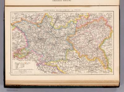
Brandenburg, Schlesien, Posen
Neuer Handatlas über alle Theile der Erde Kiepert, Heinrich Verlag von Dietrich Reimer
Provinz Brandenburg

Tabula Marchionatus Brandenburgici et Ducatus Pomeraniae quae sunt Pars Septentrionalis Circuli Saxoniae Superioris novissime edita
1 : 1000000 Mollova mapová sbírka Homann, Johann Baptist Homann, Johann Baptista
Brandenburg.
1 : 640000 Weiland, C. F. (Carl Ferdinand), d. 1847
Reise Charte durch das Churfürstenthum Brandenburg
1 : 2000000 Mollova mapová sbírka Schreiber, Johann Georg Schreiber, Johann Georg
Die Preussische Provinz Brandenburg


Brandenburg und Pommern
Allgemeiner Atlas [Walch, Johannes] im Verlag bei Johannes Walch
Germany - eastern section.
1 : 1000000 John Bartholomew and Son
Der nördliche Theil des Ober Sächsischen Kreises oder die Mark Brandenburg und das Herzogthum Pommern
1 : 880000 Braniborsko (Německo) Güssefeld, Franz L. von den Homan[n] Erben
Der nördliche Theil des Ober-Sächsischen Kreises oder die Mark Brandenburg und das Herzogthum Pommern
1 : 880000 Braniborsko (Německo) Güssefeld, Franz L. Schmidt, I.M. von den Homann. Erben
Der nördliche Theil des Ober Sächsischen Kreises oder die Mark Brandenburg und das Herzogthum Pommern
1 : 880000 Braniborsko (Německo) Güssefeld, Franz L. von den Homan[n] Erben
La Pomerania divisa in Citeriore, o Reale che spetta alla Corona di Suezia et in Vlteriore , o Ducale che appartiene all ́Elettore di Brandeburgo e Subdiuisa nelle Parti Principali, che la compognono
1 : 700000 Mollova mapová sbírka Cantelli, Giacomo De Rossi, Giovanni Giacomo
Brandenburg und Pommern
1 : 1151000 Braniborsko (Německo) Jättnig, Wilhelm Gleditsch
Die Königl. Preussische Provinz Brandenburg
1 : 625000 Berlín (Německo) Weiland, Karl Ferdinand Verlage des geogr. Instituts
Provinz Brandenburg
Grosser Hand-Atlas über alle Theile der Erde in 170 Karten Meyer, J. Verlag des Bibliographischen Instituts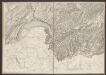
Le Marquisat et Eslectorat De Brandebourg qui fait partie du Cercle de la Haute Saxe, divisé en ses Principales Parties [Karte], in: Atlas nouveau, contenant toutes les parties du monde [...], Bd. 1, S. 327.
1 Karte aus Atlas Sanson, Nicolas Jaillot, Alexis Hubert und Mortier, Pieter
Marchionatus Brandenburgi et Ducatus Pomeraniae Tabula Quae est pars Septentrionalis Circuli Saxoniae Superioris
1 : 1000000 Mollova mapová sbírka Wit, Frederik de Wit, Frederick
Marchionatus et Electoratus Brandeburgicus, una et Ducatus Pomeraniae in suas subdivisi Ditiones Atque noviter descripti
1 : 970000 Mollova mapová sbírka Valk, Gerhard Valck, Gerard
Marchionatus Brandenburgensis in quo sunt Vetus Media et Nova Marchia et Ducatus Pomeraniae Tabula Quae est pars Septentrionalis Circuli Saxoniae Superioris
1 : 870000 Mollova mapová sbírka Danckerts, Theodorus Danckerts, Theodor
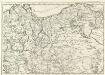
Charte über den nördlichen Theil des ober saechsischen Kreises enthaltend die Mark Brandenburg u. d. Hrz. Pom[m]ern
1 Karte : Kupferdruck ; 46 x 59 cm Güssefeld im Verlage des Industrie Comptoirs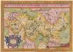
Brandeburgensis Marchae Descriptio. [Karte], in: Theatrum orbis terrarum, S. 141.
1 Karte aus Atlas Ortelius, Abraham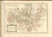
Carte Generale d'Allemagne
1 : 1300000 Mollova mapová sbírka Eisenschmidt, Johann Caspar Julien, Roch Joseph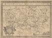
Brandeburgensis Marchae Descriptio. [Karte], in: Theatrum orbis terrarum, S. 233.
1 Karte aus Atlas Ortelius, Abraham Vrients, Jan Baptista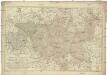
Karte von der Mark Brandenburg
1 : 514000 Braniborsko (Německo) Oesfeld, Karl Ludwig von Schneider u. Weigelschen Kunst und Buchhandlung
Die Preussische Provinz Posen, bestehend aus den Regierungs-Bezirken: Posen & Bromberg
1 : 1850000 Provinz Posen
Odra
1 : 2400000 Odra-povodí Zeměměřický úřad