Maps of Greater Poland Voivodeship

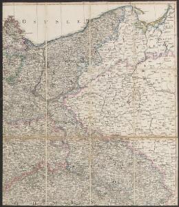
Karte von Deutschland in IV Blättern
1 : 825000 Nordost-Blatt Sotzmann, Daniel Friedrich im Verlage der A. G. Schneider und Weigels
Le Cours de l'Elbe et de l'Oder où sont les Electorats de Saxe et de Brandebourg, les Duchés de Mekelbourg et de Pomeranie
1 : 1400000 Mollova mapová sbírka Duval, Pierre Duval, Pierre
The N. E. Part of Germany
1 : 3400000 Mollova mapová sbírka Moll, Herman Moll, Hermann
Postup při tisku příruční mapy školní ČSR

L'Empire, d'Allemagne
1 : 1200000 Mollova mapová sbírka Sanson, Nicolas Quasy, Robert
[Nordöstliches Deutschland]
Schul-Atlas über alle Theile der Erde nach dem neuesten Zustande, und über das Weltgebäude Stieler, Adolf bei Justus Perthes
NE pt. of Germany.
1 : 3150000 Bowen, Emanuel
NO Deutschland.
1 : 5500000 Brudin, J. L.; Stieler, Adolf
The N.E. part of Germany.
1 : 3500000 Moll, Herman, d. 1732
Die Königl. Preussischen Provinzen Brandenburg Pommern Sachsen und Schlesien nebst Mecklenburg
Mitteleuropa
Operations Karte im Jahr 1759 ...

Oder
Oder, Flusslauf
The eastern front
1 : 2280000 Shows railways, main highways, and the Front as of Feb. 12-19 (1945.). "Restricted." "No. 6180 - R & A, OSS. 20 February 1945." United States. Office of Strategic Services. Research and Analysis Branch. [Washington, D.C.] : Lithographed in Reproduction Branch, OSS

Nordöstliches Deutschland
Preußen
Haute Saxe.
1 : 1900000 Clouet, J. B. L. (Jean-Baptiste Louis), b. 1730
Novissima Poloniae regni Descriptio
1 : 1600000 Mollova mapová sbírka Janssonius, Johannes Janssonius, Johannes I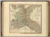
Upper Saxony, Silesia, Lusatia.
1 : 1340000 Cary, John, ca. 1754-1835
Upper Saxony.
1 : 2900000 Bowen, Frances
Die preusischen Provinzen Preussen und Posen und dan Königreich Polen
1 : 1220000 Polsko Gräf, C. Dellinger Geographisches Institut
Odra
1 : 2400000 Odra-povodí Zeměměřický úřad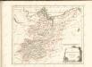

Mitteldeutschland
Volksschul-Atlas über alle Teile der Erde Lange, Henry Druck und Verlag von Georg Westermann
Nordost-Deutschland
1 : 2000000 Německo severní Kocen, Blaž Eduard Hölzel
Nord-östliches Deutschland
1 : 1850000 Braniborsko (Německo) Ausfeld, Johann Carl Justus Perthes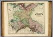
Upper Saxony.
1 : 1500000 Lizars, Daniel
Bojiště válek husitských v letech 1419-1434 : do bitvy u Lipan 30. května 1434
1 : 1500000 Evropa střední Kuffner, Hanuš Wagner, Jan Eduard R. Prombergr
Posádky v Zemích koruny české a v zemích zahraničních
1 : 1500000 Evropa střední Kuffner, Hanuš Wagner, Jan Eduard nákladem R. Prombergra
Schlesien, Posen, Odergebiet
1 : 2250000 Schlesien, Provinz Posen, Skizzenbuch