Maps of Niederösterreich

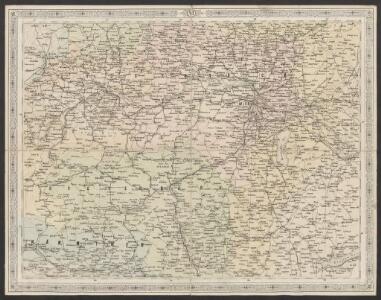
Strassen- und Eisenbahnkarte des oesterreichischen Kaiserthumes
1 : 864000 Blatt 6 Schaller, G. K.K. Militärisch-Geografisches Institut, Karten-Evidenthaltungs-Abteilung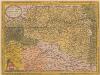
Austriae Ducatus Chorographia [Karte], in: Theatrum orbis terrarum, S. 67.
1 Karte aus Atlas Ortelius, Abraham
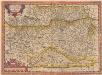
Austriae ducatus chorographia
1 : 590000 Rakousko Lazius, Wolfgang Ortelius, Abraham A. Ortelius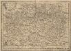
Austriae Descirp. [Karte], in: Theatrum orbis terrarum, S. 257.
1 Karte aus Atlas Ortelius, Abraham Vrients, Jan Baptista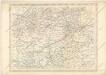
Strassen und Eisenbahnkarte des oesterreichischen Kaiserthumes
Austriae Descirp. [Karte], in: Theatrum orbis terrarum, S. 165.
1 Karte aus Atlas Ortelius, Abraham
Post und Eisenbahnkarte der Österreichisch-Ungarischen Monarchie
[38][38] Circuli Austriaci pars septentrionalis ..., uit: Atlas sive Descriptio terrarum orbis
Annotatie: Gedigitaliseerde versie. Amsterdam. Heiloo : Picturae (vervaardiger), 2015. tiff-bestand. Gedigitaliseerd: 07-01-2015; Origineel: Universiteitsbibliotheek Vrije Universiteit (XL.05127.-) ; Netherlands; Titelpagina ontbreekt Wit, Frederik de Amsterdam : Frederick de Wit
Austria archiducatus. [Karte], in: Gerardi Mercatoris Atlas, sive, Cosmographicae meditationes de fabrica mundi et fabricati figura, S. 403.
1 Karte aus Atlas Mercator, Gerhard Montanus, Petrus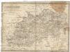
Oesterreich ob- und unter der Enns
1 : 925000 Dolní Rakousko (Rakousko) Mollo, Tranquillo T. Mollo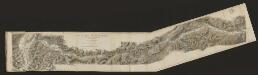
Austria Archiducatus [Karte], in: Gerardi Mercatoris et I. Hondii Newer Atlas, oder, Grosses Weltbuch, Bd. 1, S. 334.
1 Karte aus Atlas Mercator, Gerhard und Hondius, Jodocus Jansson, Jan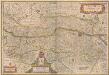
Austria Archiducatus [Karte], in: Novus atlas absolutissimus, Bd. 2, S. 276.
1 Karte aus Atlas Janssonius Offizin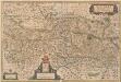
Austria Archiducatus [Karte], in: Novus Atlas, das ist, Weltbeschreibung, Bd. 1, S. 216.
1 Karte aus Atlas Blaeu, Joan Blaeu, Willem Janszoon
Oesterreich, Steyermark, Illyrien. Ungarn. Comitate: Wieselburg, Oedenburg, Eisenburg, Szalader, Schimegher und Preßburger
Ungarn Verkehrsweg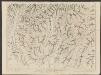
Austria Archiducatus [Karte], in: Theatrum orbis terrarum, sive, Atlas novus, Bd. 1, S. 127.
1 Karte aus Atlas Blaeu, Joan Blaeu, Willem Janszoon
Eisenbahnkarte der k.u.k. oesterreichisch-ungarischen Monarchie

Austria Archiducatus [Karte], in: Le théâtre du monde, ou, Nouvel atlas contenant les chartes et descriptions de tous les païs de la terre, Bd. 1, S. 245.
1 Karte aus Atlas Blaeu, Willem Janszoon und Blaeu, Joan Blaeu, Willem Janszoon
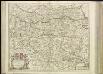
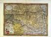
Circuli Austriaci Pars Septentrionalis in qua Archiducatus Austriae et Ducatus Stiriae accuratissime divisi oftenduntur
1 : 587000 Mollova mapová sbírka Wit, Frederik de Mortier, Pierre I.
Geologische karte der Republik Österreich und der Nachbargebiete: Die Ostalpen, ihre Ausläufer und Vorlande nebst den angrenzenden Teilen der fränkisch-schwäbischen Alb und des böhmischen Massivs
Vetters, Hermann.
Erzherzogthum Oesterreich
1 : 1030000 Rakousko Theinert, A. Flemming, C. C. Flemming
Partie Du Cercle D'Austriche Sçavoir L'Archiduché D'Austriche Divisé en Haute et Basse [Karte], in: Atlas nouveau, contenant toutes les parties du monde [...], Bd. 1, S. 259.
1 Karte aus Atlas Sanson, Nicolas Jaillot, Alexis Hubert und Mortier, Pieter
Erzherzogthum Österreich

Nova et accurrata Charta Archiducatus Austriaci cum adhaerentib; Regionib;
1 : 1230000 Mollova mapová sbírka Haupt, Gottfried Jacob Haupt, Gottfried Jacob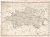
Erz Herzogthum Oesterreich ob und unter der Enns
1 : 506000 Rakousko Mollo, Tranquillo T. Mollo
Die Krönlander Oesterreich unter und ob der Enns und Salzburg
Dolní Rakousko (Rakousko) Marco Berra
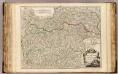
Avstriae dvcatvs chorographia
1 Karte : Kupferdruck ; 31 x 44 cm Lazius; Ortelius s.n.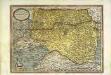
Avstriae dvcatvs chorographia
1 Karte : Kupferdruck ; 31 x 44 cm Lazius; Ortelius s.n.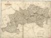
Erzherzogthum Österreich