Maps of Transdanubia

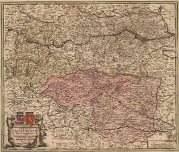
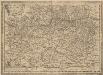
Circuli Austriaci Pars Septentrionalis in qua Archiducatus Austriae et Ducatus Stiriae accuratissime divisi oftenduntur
1 : 587000 Mollova mapová sbírka Wit, Frederik de Mortier, Pierre I.
Circuli Austriaci Orientalior Pars
1 : 820000 Mollova mapová sbírka Valk, Gerhard Valck, Gerard
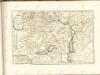
Germania
1 : 920000 Mollova mapová sbírka Danckerts, Justus Danckerts, Justus
Radfahrer-übersichstkarte von Deutschland

Sheet VIII: Karte Des Oesterreichischen Kaiserstaates.
1 : 576000 Scheda, Josef
Eisenbahnkarte der k.u.k. oesterreichisch-ungarischen Monarchie

Strassen- und Eisenbahnkarte des oesterreichischen Kaiserthumes
1 : 864000 Blatt 6 Schaller, G. K.K. Militärisch-Geografisches Institut, Karten-Evidenthaltungs-Abteilung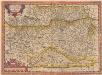
Austriae Descirp. [Karte], in: Theatrum orbis terrarum, S. 165.
1 Karte aus Atlas Ortelius, Abraham
Geologische karte der Republik Österreich und der Nachbargebiete: Die Ostalpen, ihre Ausläufer und Vorlande nebst den angrenzenden Teilen der fränkisch-schwäbischen Alb und des böhmischen Massivs
Vetters, Hermann.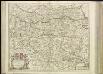
[38][38] Circuli Austriaci pars septentrionalis ..., uit: Atlas sive Descriptio terrarum orbis
Annotatie: Gedigitaliseerde versie. Amsterdam. Heiloo : Picturae (vervaardiger), 2015. tiff-bestand. Gedigitaliseerd: 07-01-2015; Origineel: Universiteitsbibliotheek Vrije Universiteit (XL.05127.-) ; Netherlands; Titelpagina ontbreekt Wit, Frederik de Amsterdam : Frederick de Wit
Austriae ducatus chorographia
1 : 590000 Rakousko Lazius, Wolfgang Ortelius, Abraham A. Ortelius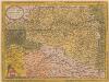
Austriae Ducatus Chorographia [Karte], in: Theatrum orbis terrarum, S. 67.
1 Karte aus Atlas Ortelius, Abraham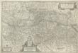
Avstria Archidvcatvs
1 : 640000 Mollova mapová sbírka Lazius, Wolfgang Blaeu, Willem Jansz.
Austria Antiqva Cis Danvbiana Pannonica
1 : 2360000 Mollova mapová sbírka Clüver, Philipp Fuhrmann, Mathias
Circuli Austriaci in quo sunt archiducatus Austriae ducatus Stiriae Carintiae Carniolae comitatus Tirolis et episcopatus Tridentini novissima descriptio
1 : 920000 Evropa střední Danckerts, Justus per Iustinum Danckerts
Letecká mapa Evropy
Strassen und Eisenbahnkarte des oesterreichischen Kaiserthumes

Post und Eisenbahnkarte der Österreichisch-Ungarischen Monarchie
Austriae Descirp. [Karte], in: Theatrum orbis terrarum, S. 257.
1 Karte aus Atlas Ortelius, Abraham Vrients, Jan Baptista
Oesterreich, Steyermark, Illyrien. Ungarn. Comitate: Wieselburg, Oedenburg, Eisenburg, Szalader, Schimegher und Preßburger
Ungarn Verkehrsweg
A Dunavölgy vizszabályozasi átnézeti térképe

VIII, uit: General-Karte des oesterreichischen Kaiserstaates mit einem grossen Theile der angrenzenden Länder / durch Josef Scheda ... bearb. und hrsg
1 : 576000 Annotatie geografische gegevens: Maatstokken: oesterreichische Meilen, geografische oder deutsche Meilen, preussische Meilen, türkische Berri, französische Lieues, russische Werste; Maatstok per blad: wiener Klafter, öster. Meilen; Blad XIX: statistische en taalkundige informatie; Blad XIX: legenda [Wien : K.K. Militärisch-Geografisches Institut]
[Rakousko-slovensko-maďarské pomezí].
Burgenland (Rakousko) Kipferling, Karl Joseph Walch, Johann
Übersichtskarte von Mittel - Europa

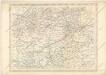
General Post und Strassen Karte des Herzoghtums Steyermark
1 : 390000 Mariazell (Rakousko) Schulz, R. A. Artaria
General Post und Strassen Karte des Herzoghtums Steyermark
1 : 390000 Mariazell (Rakousko) Schulz, R. A. Artaria
Wien, Graz, Budapest
1 : 750000 Budapešť (Maďarsko : oblast) Karl, Ed. K. u. k. Militärgeographisches Institut
Wien, Graz, Budapest
1 : 750000 Budapešť (Maďarsko : oblast) K.u.k. militär-geographisches Institut