Maps of Niederösterreich

Nova et accurrata Charta Archiducatus Austriaci cum adhaerentib; Regionib;
1 : 1230000 Mollova mapová sbírka Haupt, Gottfried Jacob Haupt, Gottfried Jacob
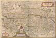
L'Archi Duché d'Autriche divisee en 8. Quartier
1 : 590000 Mollova mapová sbírka Nolin, Jean-Baptiste Nolin, Jean Baptiste II.
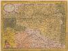
Erzherzogthum Oesterreich
1 : 1030000 Rakousko Theinert, A. Flemming, C. C. Flemming
Austriae Descirp. [Karte], in: Theatrum orbis terrarum, S. 257.
1 Karte aus Atlas Ortelius, Abraham Vrients, Jan Baptista
Austria Archiducatus [Karte], in: Gerardi Mercatoris et I. Hondii Newer Atlas, oder, Grosses Weltbuch, Bd. 1, S. 334.
1 Karte aus Atlas Mercator, Gerhard und Hondius, Jodocus Jansson, Jan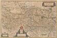
Austria Archiducatus [Karte], in: Novus Atlas, das ist, Weltbeschreibung, Bd. 1, S. 216.
1 Karte aus Atlas Blaeu, Joan Blaeu, Willem Janszoon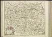
[38][38] Circuli Austriaci pars septentrionalis ..., uit: Atlas sive Descriptio terrarum orbis
Annotatie: Gedigitaliseerde versie. Amsterdam. Heiloo : Picturae (vervaardiger), 2015. tiff-bestand. Gedigitaliseerd: 07-01-2015; Origineel: Universiteitsbibliotheek Vrije Universiteit (XL.05127.-) ; Netherlands; Titelpagina ontbreekt Wit, Frederik de Amsterdam : Frederick de Wit
AVSTRIA | ARCHIDVCATVS
auctore Wolfgango Lazio. [Amsterdam : Joan Blaeu]
Austria archiducatus. [Karte], in: Gerardi Mercatoris Atlas, sive, Cosmographicae meditationes de fabrica mundi et fabricati figura, S. 403.
1 Karte aus Atlas Mercator, Gerhard Montanus, Petrus
Austria Archiducatus [Karte], in: Le théâtre du monde, ou, Nouvel atlas contenant les chartes et descriptions de tous les païs de la terre, Bd. 1, S. 245.
1 Karte aus Atlas Blaeu, Willem Janszoon und Blaeu, Joan Blaeu, Willem Janszoon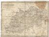
Oesterreich ob- und unter der Enns
1 : 925000 Dolní Rakousko (Rakousko) Mollo, Tranquillo T. Mollo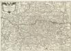
Arciducato d’Avstria che parte del circolo del Med.° nome diuiso da
1 : 587000 Mollova mapová sbírka Cantelli, Giacomo Donia, Francesco De Rossi, Giovanni Giacomo
Erzherzogthum Österreich
Rakousko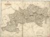
Erzherzogthum Österreich
Austriae Ducatus Chorographia [Karte], in: Theatrum orbis terrarum, S. 67.
1 Karte aus Atlas Ortelius, Abraham
Erzherzogthum Österreich
Das Erzherzogthum Oesterreich ob- und unter der Enns
1 : 643000 Rakousko Weiland, Karl Ferdinand im Verlage des Geographischen Instituts
Das Erzherzogthum Oesterreich ob- und unter der Enns
1 : 643000 Rakousko Weiland, Karl Ferdinand im Verlage des Geographischen Instituts
Strassen- und Eisenbahnkarte des oesterreichischen Kaiserthumes
1 : 864000 Blatt 6 Schaller, G. K.K. Militärisch-Geografisches Institut, Karten-Evidenthaltungs-Abteilung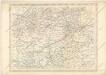
Strassen und Eisenbahnkarte des oesterreichischen Kaiserthumes
Austria Archiducatus [Karte], in: Novus atlas absolutissimus, Bd. 2, S. 276.
1 Karte aus Atlas Janssonius Offizin
Austria Archiducatus [Karte], in: Theatrum orbis terrarum, sive, Atlas novus, Bd. 1, S. 127.
1 Karte aus Atlas Blaeu, Joan Blaeu, Willem Janszoon
Die Krönlander Oesterreich unter und ob der Enns und Salzburg
Dolní Rakousko (Rakousko) Marco Berra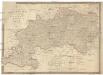
[K]arte des [Erzh]erzogthums [Oes]terreich [ob] und unter der Enns mit Salzburg
1 : 767000 Dolní Rakousko (Rakousko) Fried, Franz Artaria und Comp.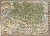
Avstriae Dvcatvs Chorographia
1 : 1120000 Mollova mapová sbírka Lazius, Wolfgang Diesthem, Aegidius Copenius
Carte de l'archiduché d'Autriche avec Salzbourg
1 : 890000 Rakousko Raffelsperger, Franz Bermann, Jeremias au Dépôt des cartes typografiées
Carta dell' arciducato d'Austria con Salisburgo
1 : 890000 Rakousko Raffelsperger, Franz Magazzino delle carte tipografiate
Karte des Erzherzogthumes Österreich mit Salzburg
1 : 890000 Rakousko Raffelsperger, Franz im Typographischen Landkarten Verlage