Maps of Niederösterreich

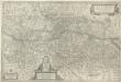
Partie Du Cercle D'Austriche Sçavoir L'Archiduché D'Austriche Divisé en Haute et Basse [Karte], in: Atlas nouveau, contenant toutes les parties du monde [...], Bd. 1, S. 259.
1 Karte aus Atlas Sanson, Nicolas Jaillot, Alexis Hubert und Mortier, Pieter
Probeauszug aus dem ersten Blatte der Charte von Europa
Morava (Česko) Anville, Jean-Baptiste Bourguinon d' Trassler, Josef Jiří I.G. Trassler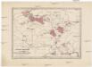
Detaillirte Darstellung der vorzüglichsten Rübenzucker-Fabriks-Bezirke der österreichischen Monarchie
Rakousko (1804-1867)
Verkehrs-Karte von Böhmen, Mähren, Schlesien, Erzh. Oesterreich und den angrenzenden Landestheilen
1 : 1070000 Rakousko Bomsdorff, Th. von Karl Prochaska
Austria Archiducatus [Karte], in: Theatrum orbis terrarum, sive, Atlas novus, Bd. 1, S. 127.
1 Karte aus Atlas Blaeu, Joan Blaeu, Willem Janszoon
Austria Archiducatus [Karte], in: Novus atlas absolutissimus, Bd. 2, S. 276.
1 Karte aus Atlas Janssonius Offizin
Austria Archiducatus [Karte], in: Gerardi Mercatoris et I. Hondii Newer Atlas, oder, Grosses Weltbuch, Bd. 1, S. 334.
1 Karte aus Atlas Mercator, Gerhard und Hondius, Jodocus Jansson, Jan
Austria Archiducatus [Karte], in: Novus Atlas, das ist, Weltbeschreibung, Bd. 1, S. 216.
1 Karte aus Atlas Blaeu, Joan Blaeu, Willem Janszoon
Austria Archiducatus [Karte], in: Le théâtre du monde, ou, Nouvel atlas contenant les chartes et descriptions de tous les païs de la terre, Bd. 1, S. 245.
1 Karte aus Atlas Blaeu, Willem Janszoon und Blaeu, Joan Blaeu, Willem Janszoon
Erz Herzogthum Oesterreich ob und unter der Enns
1 : 506000 Rakousko Mollo, Tranquillo T. Mollo
Probe Auszug aus dem ersten Blatte der Charte von Europa
Evropa střední Anville, Jean-Baptiste Bourguinon d' I. G. Trassler
Geognostische Karte des Beckens von Wien und der Gebirge, die dasselbe umgeben
1 : 450000 Partsch, Paul [s.n.]
Carte de l'archiduché d'Autriche avec Salzbourg
1 : 890000 Rakousko Raffelsperger, Franz Bermann, Jeremias au Dépôt des cartes typografiées
Carta dell' arciducato d'Austria con Salisburgo
1 : 890000 Rakousko Raffelsperger, Franz Magazzino delle carte tipografiate
Karte des Erzherzogthumes Österreich mit Salzburg
1 : 890000 Rakousko Raffelsperger, Franz im Typographischen Landkarten Verlage
Mapa cukrovarů a raffinerií Rakousko-Uherska
1 : 600000 Halič (Polsko a Ukrajina) Zikmund, V. V. Zikmund
Austria archiducatus. [Karte], in: Gerardi Mercatoris Atlas, sive, Cosmographicae meditationes de fabrica mundi et fabricati figura, S. 403.
1 Karte aus Atlas Mercator, Gerhard Montanus, Petrus
Theatre De La Guerre En Austriche, Baviere, Souabe, Le Tirol et le Pays aux Environs. [Karte], in: Atlas nouveau, contenant toutes les parties du monde [...], Bd. 1, S. 270.
1 Karte aus Atlas Sanson, Nicolas Jaillot, Alexis Hubert und Mortier, Pieter
Austriae Descirp. [Karte], in: Theatrum orbis terrarum, S. 165.
1 Karte aus Atlas Ortelius, Abraham
AVSTRIA | ARCHIDVCATVS
auctore Wolfgango Lazio. [Amsterdam : Joan Blaeu]
Das Erzherzogthum Oesterreich ob- und unter der Enns
1 : 643000 Rakousko Weiland, Karl Ferdinand im Verlage des Geographischen Instituts
Das Erzherzogthum Oesterreich ob- und unter der Enns
1 : 643000 Rakousko Weiland, Karl Ferdinand im Verlage des Geographischen Instituts
Erzherzogthum Österreich

Republique Tchecoslovaque

Erzherzogthum Österreich
Rakousko
Austriae Ducatus Chorographia [Karte], in: Theatrum orbis terrarum, S. 67.
1 Karte aus Atlas Ortelius, Abraham
Erzherzogthum Österreich
Avstria Archidvcatvs
1 : 640000 Mollova mapová sbírka Lazius, Wolfgang Blaeu, Willem Jansz.
[K]arte des [Erzh]erzogthums [Oes]terreich [ob] und unter der Enns mit Salzburg
1 : 767000 Dolní Rakousko (Rakousko) Fried, Franz Artaria und Comp.
![Partie Du Cercle D'Austriche Sçavoir L'Archiduché D'Austriche Divisé en Haute et Basse [Karte], in: Atlas nouveau, contenant toutes les parties du monde [...], Bd. 1, S. 259.](https://images-0.georeferencer.com/images/iiif/242623970158/full/,300/0/native.jpg)

