Maps of Austria
Oesterreich ob- und unter der Enns
1 : 925000 Dolní Rakousko (Rakousko) Mollo, Tranquillo T. Mollo
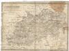
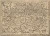
Austriae ducatus chorographia
1 : 590000 Rakousko Lazius, Wolfgang Ortelius, Abraham A. Ortelius
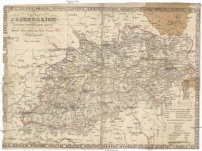
Erzherzogthum Österreich

Die Krönlander Oesterreich unter und ob der Enns und Salzburg
Dolní Rakousko (Rakousko) Marco Berra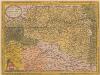
Austriae Ducatus Chorographia [Karte], in: Theatrum orbis terrarum, S. 67.
1 Karte aus Atlas Ortelius, Abraham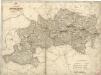
Erzherzogthum Österreich
Austriae Descirp. [Karte], in: Theatrum orbis terrarum, S. 257.
1 Karte aus Atlas Ortelius, Abraham Vrients, Jan Baptista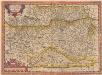
Austriae Descirp. [Karte], in: Theatrum orbis terrarum, S. 165.
1 Karte aus Atlas Ortelius, Abraham
Erzherzogthum Österreich
Rakousko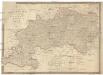
[K]arte des [Erzh]erzogthums [Oes]terreich [ob] und unter der Enns mit Salzburg
1 : 767000 Dolní Rakousko (Rakousko) Fried, Franz Artaria und Comp.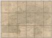
Das Erzherzogthum Oesterreich ob- und unter der Enns
1 : 643000 Rakousko Weiland, Karl Ferdinand im Verlage des Geographischen Instituts
Das Erzherzogthum Oesterreich ob- und unter der Enns
1 : 643000 Rakousko Weiland, Karl Ferdinand im Verlage des Geographischen Instituts
Strassen- und Eisenbahnkarte des oesterreichischen Kaiserthumes
1 : 864000 Blatt 6 Schaller, G. K.K. Militärisch-Geografisches Institut, Karten-Evidenthaltungs-Abteilung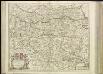
[38][38] Circuli Austriaci pars septentrionalis ..., uit: Atlas sive Descriptio terrarum orbis
Annotatie: Gedigitaliseerde versie. Amsterdam. Heiloo : Picturae (vervaardiger), 2015. tiff-bestand. Gedigitaliseerd: 07-01-2015; Origineel: Universiteitsbibliotheek Vrije Universiteit (XL.05127.-) ; Netherlands; Titelpagina ontbreekt Wit, Frederik de Amsterdam : Frederick de Wit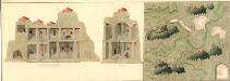
Plann deren Bergwerg Wendelstein, und Stagevoi
Mollova mapová sbírka Geyer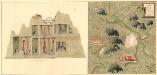
Plan des Bergwergs Weispriach
Mollova mapová sbírka Geyer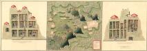
Plan der Bergwerg in der Creitzen
Mollova mapová sbírka Geyer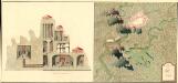
Plan des Bergwergs St. Anna an der Miss
Mollova mapová sbírka Geyer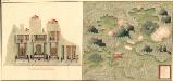
Plan des Bergwergs Wipenstein
Mollova mapová sbírka Geyer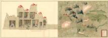
Plan der Bergwerg Schreflhoff, und Theifenegg
Mollova mapová sbírka Geyer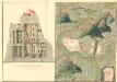
Plan des Bergwergs Serniz
Mollova mapová sbírka Geyer
Carte de l'archiduché d'Autriche avec Salzbourg
1 : 890000 Rakousko Raffelsperger, Franz Bermann, Jeremias au Dépôt des cartes typografiées
Carta dell' arciducato d'Austria con Salisburgo
1 : 890000 Rakousko Raffelsperger, Franz Magazzino delle carte tipografiate
Karte des Erzherzogthumes Österreich mit Salzburg
1 : 890000 Rakousko Raffelsperger, Franz im Typographischen Landkarten Verlage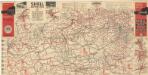
Strassen Zustands-Karte und Stadtpläne mit Durchfahrten von Österreich

Erzherzogthum Oesterreich
1 : 1030000 Rakousko Theinert, A. Flemming, C. C. Flemming
Karte des Erzherzogthumes Oesterreich ob und unter der Enns und des Herzogthumes Salzburg
1 : 432000 Dolní Rakousko (Rakousko) Steinhauser, Anton Artaria
General-Post und Strassen-Karte des Erzherzogthums Oesterreich
1 : 540000 Rakousko Fried, Franz Artaria & Comp.
General-Post und Strassen-Karte des Erzherzogthums Oesterreich nebst einem grossen Theile von Steyermark
1 : 540000 Rakousko Fried, Franz Artaria & Comp.
General- Post und Strassen-Karte des Erzherzogthums Oesterreich
1 : 540000 Rakousko Fried, Franz bei Artaria & Comp.
General-Post und Strassen-Karte des Erzherzogthums Oesterreich
1 : 540000 Rakousko Fried, Franz Biller, Bernh. bei Artaria