Maps of Metropolitan France

Charte von Frankreich
1 : 2400000 Francie Streit, Friedrich Wilhelm Geograph. Instituts
Charte von Frankreich
1 : 2400000 Francie Streit, Friedrich Wilhelm Geograph. Instituts
Gallia
1 : 4250000 Francie Plancius, Petrus Petrus Plancius
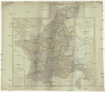
Carte générale de l'Empire Français et du Royaume d'Italie suivant les nouvelles divisions : avec les chefs-lieux de préfecture et l'indication des principales routes
1 : 2000000 par C.F. Delamarche Barriere sculpsit. À Paris : chez l'auteur
Tabula Moderna Francie [Karte], in: [Clavdii Ptholomei Cosmographi ...], S. 257.
1 Karte aus Atlas Nicolaus Germanus [und Ptolemaeus, Claudius]
Nouvelle carte de poste de tout l'empire Français, de l'Anglettere, de l'Italie, d'une partie de l'Espagne et de l'Allemagne etc
Anglie Hinrichs, Johann Conrad J.C. Hinrichs
Galliae Regni Potentiss: Nova Descriptio. [Karte], in: Theatrum orbis terrarum, S. 30.
1 Karte aus Atlas Ortelius, Abraham
Karte von Frankreich
1 : 4500000 Belgie Mollo, Tranquillo Tranquillo Mollo
[Frankreich]
Historisch-genealogisch-geographischer Atlas von Le Sage Las Cases, Emmanuel Auguste Dieudonné Marius Joseph de Johann Velten, Kunsthändler
Nouvelle carte de poste de tout l'empire Français, de l'Angleterre, de l'Italie, d'une partie de l'Espagne et de l'Allemagne, etc. = Neueste Post Karte vom ganzen Französischen Reiche, England, Italien, und einem Theile von Spanien und Deutschland uzw. / hrsg. und verlegt von J.C. Hinrichs
1 : 2800000 Hinrichs, J. C. Leipzig : Hinrichs
Carte de la France : divisée en 133 départements et en arrondissements communaux ... / par J.B. Poirson
1 : 1750000 titelvariant: Carte de l'empire Français; Annotatie: Omslagtitel: Carte de l'empire Français Poirson, J. B. Paris : Jean
LA FRANCE en 1812
Francie Las Cases, Emmanuel-Auguste-Dieudonné Didot, Pierre Jules Didot Ainé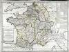
Franciæ status sub regibus primæ stirpis
1 Karte : Kupferdruck ; 48 x 65 cm Robert de Vaugondy; Delamarche chez le Sr. Delamarche géographe rue du Foin Saint Jacques au collége de M.e Gervais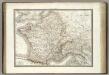
Gaules.
1 : 3000000 Lapie, M. (Pierre), 1779-1850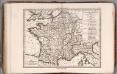
Gallae Antiquae in Septem et Decem Provinciis Divisa ... 1825.
1 : 4400000 Delamarche, Felix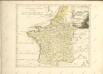

Outline Europe.
1 : 4600000 Wauthier, J. M.
Europe.
1 : 4600000 Wauthier, J. M.
Gallia Vetus Ad Iulii Caesaris commentaria. [Karte], in: Novus atlas absolutissimus, Bd. 4, S. 23.
1 Karte aus Atlas Janssonius Offizin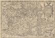
Galliae Regni Potentiss: Nova Descriptio [Karte], in: Theatrum orbis terrarum, S. 110.
1 Karte aus Atlas Ortelius, Abraham Vrients, Jan Baptista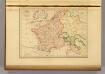
Empire France et Royaume d"Italie, 1812.
1 : 6900000 Malte-Brun, Conrad, 1775-1826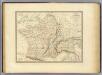
Gaule, Italie septentrionale, Germanie.
1 : 3200000 Andriveau-Goujon, J.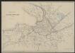
Gallia Vetus Ad Iulii Caesaris commentaria. [Karte], in: Gerardi Mercatoris et I. Hondii Newer Atlas, oder, Grosses Weltbuch, Bd. 2, S. 152.
1 Karte aus Atlas Mercator, Gerhard und Hondius, Jodocus Jansson, Jan
Francie, Belgie, Nizozemí, Lucembursko

Galliae regni potentiss: nova descriptio
1 Karte : Kupferdruck ; 32 x 49 cm Jolivet; Ortelius s.n.
Galliae regni potentiss: nova descriptio
1 Karte : Kupferdruck ; 32 x 49 cm Jolivet; Ortelius s.n.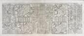
Nouvelle carte des differents etats de la monarchie françoise sous Iule Cesar, sous les rois de la premiere
4 Karten auf 2 Blättern : Kupferdruck ; Bildgrösse 38 x 96 cm Châtelain s.n.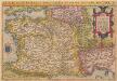
Galliae Regni Potentiss: Nova Descriptio [Karte], in: Theatrum orbis terrarum, S. 63.
1 Karte aus Atlas Ortelius, Abraham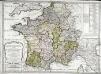
Galliarum descriptio
1 Karte : Kupferdruck ; 48 x 66 cm Robert de Vaugondy; Sanson; Delamarche; Delahaye; Sanson chez le Sr. Delamarche géographe rue du Foin St. Jacques au collége de m.tre Gervais