Maps of Metropolitan France

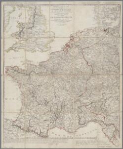
Nouvelle carte de poste de tout l'empire Français, de l'Angleterre, de l'Italie, d'une partie de l'Espagne et de l'Allemagne, etc. = Neueste Post Karte vom ganzen Französischen Reiche, England, Italien, und einem Theile von Spanien und Deutschland uzw. / hrsg. und verlegt von J.C. Hinrichs
1 : 2800000 Hinrichs, J. C. Leipzig : Hinrichs
Nouvelle carte de poste de tout l'empire Français, de l'Anglettere, de l'Italie, d'une partie de l'Espagne et de l'Allemagne etc
Anglie Hinrichs, Johann Conrad J.C. Hinrichs
[Frankreich]
Historisch-genealogisch-geographischer Atlas von Le Sage Las Cases, Emmanuel Auguste Dieudonné Marius Joseph de Johann Velten, Kunsthändler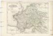
Die Reiche der Carolinger
1 : 8400000 Evropa západní

Die Reiche der Karolinger.
1 : 5300000 Spruner von Merz, Karl
Outline Europe.
1 : 4600000 Wauthier, J. M.
Europe.
1 : 4600000 Wauthier, J. M.
L'Empre. de Charlemagne de 768 a 814.
1 : 5800000 Houze, Antoine Philippe
Carte de la France : divisée en 133 départements et en arrondissements communaux ... / par J.B. Poirson
1 : 1750000 titelvariant: Carte de l'empire Français; Annotatie: Omslagtitel: Carte de l'empire Français Poirson, J. B. Paris : Jean
Carte pour l'intelligence de l'histoire d'Angleterre
1 Karte : Kupferdruck ; 26 x 26 cm, Bildgrösse 35 x 46 cm Châtelain s.n.
[Geschichtlich-geographischer Atlas von Europa :] X. Karte von Mittel-Europa mit der Provinzial-Eintheilung der verschiedenen Staaten
entworfen und gezeichnet durch Ferd. Aug. v. Witzleben [Berlin etc.] : [Mittler]
Carte générale de l'Empire Français et du Royaume d'Italie suivant les nouvelles divisions : avec les chefs-lieux de préfecture et l'indication des principales routes
1 : 2000000 par C.F. Delamarche Barriere sculpsit. À Paris : chez l'auteur
Der Sieg im Westen [Victory in the West]

Gallia et Germania ultimorum Romani Imperii temporum aequalis
1 : 4000000 Mollova mapová sbírka Liebe, Christian Sigismund
Die Republik und das Kaiserthum Frankreich mit seinen Bundes-Staaten.
1 : 5200000 Spruner von Merz, Karl
Neueste Eisenbahn-Karte von Central-Europa
1 : 4000000 Evropa střední Issleib & Rietzschel
Demembrement de l'Empre. de Charlemagne.
1 : 5800000 Houze, Antoine Philippe

Rozšíření nejstarší keramiky české v Evropě
Evropa
Gallia, Britannia, Germania, Provinciae danuvienses.
1 : 5000000 Kiepert, Heinrich, 1818-1899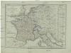
Karte von Frankreich
1 : 4500000 Belgie Mollo, Tranquillo Tranquillo Mollo
Gallia
1 : 4250000 Francie Plancius, Petrus Petrus Plancius
Tableau l'historie de France.
1 : 8250000 Duval, Henri
Die Zeit der ersten franz. Republik
Frankreich, Deutschland, Französische Revolution
Gallia Germania Britannia
Schul-Atlas der alten Welt bei Justus Perthes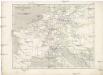
Napoleon's Kaiserreich im Jahre 1812
Evropa západní
30-31. Francia, France.
1 : 3000000 Touring club italiano
Charte von Frankreich
1 : 2400000 Francie Streit, Friedrich Wilhelm Geograph. Instituts