Maps of okres Litoměřice

Kartenskizze zur Entwicklung des Moldau-Elbetales
1 : 100000 Labe (Česko a Německo : řeka : střední tok)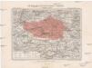
Generální mapa okresního hejtmanství Roudnického
1 : 220000 Roudnice nad Labem-oblast (Česko) Wagner, Jan Eduard F. Kytka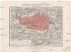
Generální mapa okresního hejtmanství Roudnického
1 : 220000 Roudnice nad Labem-oblast (Česko) Wagner, Jan Eduard F. Kytka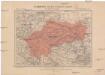
Generální mapa okresního hejtmanství Slánského [sic]
1 : 220000 Slaný-oblast (Česko) Wagner, Jan Eduard F. Kytka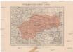
Generální mapa okresního hejtmanství Slánského [sic]
1 : 220000 Slaný-oblast (Česko) Wagner, Jan Eduard F. Kytka
Mapa hradů, zámků a tvrzí v Rakovnicku a Slánsku
1 : 200000 Rakovník (Česko : oblast) Král z Dobré Vody, Vojtěch Šimáček
Eisenbahn Karte Wien-Dresden, Ollmütz-Trübau
1 : 72000 Blatt 14 Minarzik, Anselm J. Rauh
Mapa politického a školního okresu Roudnického
1 : 100000 Roudnice nad Labem-oblast (Česko) Okresní výbor školní
Velvary a okolí
1 : 75000 Velvary (Česko : oblast) Vojenský zeměpisný ústav
Raudnitz und Juncferteinitz.
from Spezialkarte der osterreichisch-ungarischen Monarchie.
Verbindungs-Dreiecke der Grundlinie zwischen dem Lorenz- und Georgeberge mit der trigonometrischen Vermessung der Gegend um Neuschloss
1 : 230000 Středočeský kraj (Česko : 2000-)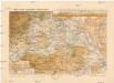
Mapa okres. hejtmanství Roudnického
1 : 100000 Budyně nad Ohří-oblast (Česko) R. Kaška
Verbindungs-Dreiecke der Grundlinie zwischen dem Lorenz- und Georgenberge mit der trigonometrischen Vermessung der Gegend um Neuschloss
Petřín (Praha, Česko)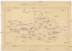
Okresní hejtmanství Roudnické
Roudnice nad Labem-oblast (Česko)
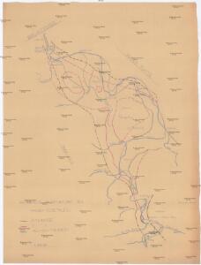
[Náčrt původní Buštěhradské dráhy]
Buštěhradská dráha (Česko : zaniklá železniční trať)
Budyňský vikariát
Budyně nad Ohří-oblast (Česko)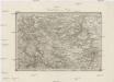
Umgebungen von Prag
1 : 144000 Praha-oblast (Česko) Gargani, Ludwig K. u. k. Militärgeographisches Institut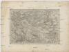
Umgebungen von Prag
Praha-oblast (Česko) Gargani, Ludwig K. u. k. Militärgeographisches Institut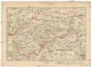
Okr. hejtmanství Slanské
1 : 150000 Slaný-oblast (Česko) Křesina, Ant. Pukl, D. Fr. Neubert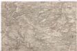
[Praha - západní okolí]
Praha-oblast (Česko)
Umgebung von Prag
1 : 144000 Praha-oblast (Česko) Knorr, A. Gargani, Ludwig
III. vojenské mapování 3852
1 : 75000
Raudnitz und Jungferteinitz
1 : 75000 Roudnice nad Labem (Česko : oblast) Ahl K. u. k. militär-geographisches Institut
Raudnitz und Jungferteinitz
1 : 75000 Roudnice nad Labem (Česko : oblast) Ahl K. u. k. Militärgeographisches Institut
Raudnitz und Jungferteinitz
1 : 75000 Roudnice nad Labem (Česko : oblast) K. u. k. Militärgeographisches Institut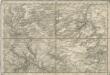
Special - Karte des Koenigreiches Boehmen

II. vojenské mapování 13
1 : 144000
Soubor přehledných map pro plánování a statistiku: 3852 – Roudnice n. Labem
Mapy plánování ČSR