Maps of okres Litoměřice
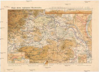
Mapa okres. hejtmanství Roudnického
1 : 100000 Budyně nad Ohří-oblast (Česko) R. Kaška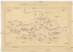
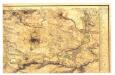
Okresní hejtmanství Roudnické
Roudnice nad Labem-oblast (Česko)
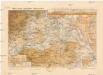
Mapa politického a školního okresu Roudnického
1 : 100000 Roudnice nad Labem-oblast (Česko) Okresní výbor školní
Budyňský vikariát
Budyně nad Ohří-oblast (Česko)
Raudnitz und Jungferteinitz
1 : 75000 Roudnice nad Labem (Česko : oblast) Ahl K. u. k. militär-geographisches Institut
Raudnitz und Jungferteinitz
1 : 75000 Roudnice nad Labem (Česko : oblast) Ahl K. u. k. Militärgeographisches Institut
Raudnitz und Jungferteinitz
1 : 75000 Roudnice nad Labem (Česko : oblast) K. u. k. Militärgeographisches Institut
Bodenkarte des Bezirkes Raudnitz a. d. E
1 : 46000 Roudnice nad Labem-oblast (Česko) Janovský, Josef reprodukce zeměpisného ústavu min. vnitra
Půdní mapa okresu Roudnice nad Labem


Gradkartenblatt
1 : 25000 Roudnice nad Labem-oblast (Česko) Bellschan, Anton
[Kartenblatt]
1 : 25000 Brozany nad Ohří (Česko) Reichsamt für Landesaufnahme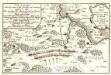
Lager der Kaÿserl. Königl. Ungarischen Armée beÿ Budin in Böhmen vor der Schlacht beÿ Lowositz Anno 1756
Mollova mapová sbírka Fridrich, Jacob Andreas Friedrich, Jacob Andreas
III. vojenské mapování 3852/2
1 : 25000
[Plan der Gegend zwischen Tursko und Theresienstadt]
1 : 61500 Litoměřice-oblast (Česko)
Lager in der Gegend vom Georgen-Berg
1 : 100000 Říp (Česko : hora : oblast)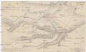
Plan der Gegend von Budin auf 3 Stund in der Länge, und 1/2 Stund in der Breite
1 : 61000 Budyně nad Ohří (Česko) Turati
Hydrografische Uibersichtskarte der Flüsse, Bäche und sonstigen Gewässer im Königreiche Boehmen
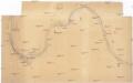
[Labe v okolí Roudnice]
Labe-tok dolní (Německo)
Exerzier-Platz bei Theresienstadt im Jahre 1846
1 : 30800 Terezín-oblast (Litoměřice, Česko)
Plan de la Bataille de Lobositz le premier octobre Ao 1756
Mollova mapová sbírka Trattner, Johann Thomas von - dílna
Plan der Gegend zwischen Tursko und Theresienstadt
1 : 61500 Budyně nad Ohří-oblast (Česko)
Ebauché du combat qui s'est donné le 1. d'octobre. 1756. entre les troupes imp. et les Prussiens pres de Lobozitz en Boheme
Lovosice-oblast (Česko) Kotzii, Car. de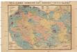
Čeňka Zahálky geologické mapy Podřipska
1 : 25000 Podřipsko (Česko) Zahálka, Čeněk
Gradkartenblatt
1 : 25000 Louny-oblast (Česko) Bellschan, Anton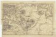
Plan der Gegend bey Lowositz in Böheim
Lovosice-oblast (Česko)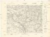
[Kartenblatt]
1 : 25000 Kokořín (Česko : oblast) Reichsamt für Landesaufnahme
[Kartenblatt]
1 : 25000 Libochovice (Česko : oblast) Reichsamt für Landesaufnahme