Maps of Hrobčice
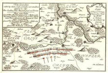
Lager der Kaÿserl. Königl. Ungarischen Armée beÿ Budin in Böhmen vor der Schlacht beÿ Lowositz Anno 1756
Mollova mapová sbírka Fridrich, Jacob Andreas Friedrich, Jacob Andreas
Litoměřice a okolí
1 : 75000 Litoměřice (Česko : oblast) Vojenský zeměpisný ústav
[Plan der Gegend zwischen Tursko und Theresienstadt]
1 : 61500 Litoměřice-oblast (Česko)
Bezirk Lobositz
1 : 72000 Lovosice-oblast (Česko) Josef Czerny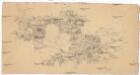
[České středohoří - západní část]
Most-oblast (Česko)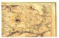

Bezirk Leitmeritz
1 : 36000 Litoměřice-oblast (Česko) Becker, H. H. Becker
Gradkartenblatt
1 : 25000 Roudnice nad Labem-oblast (Česko) Bellschan, Anton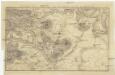
Plan der Gegend bey Lowositz in Böheim
Lovosice-oblast (Česko)
Geologische Karte des Böhmischen Mittelgebirges
1 : 25000 Kostomlaty pod Milešovkou (Česko : oblast) Hibsch, Josef Emanuel
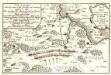
Ebauché du combat qui s'est donné le 1. d'octobre. 1756. entre les troupes imp. et les Prussiens pres de Lobozitz en Boheme
Lovosice-oblast (Česko) Kotzii, Car. de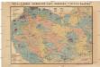
Čeňka Zahálky geologické mapy Podřipska
1 : 25000 Podřipsko (Česko) Zahálka, Čeněk
Gradkartenblatt
1 : 25000 Louny-oblast (Česko) Bellschan, Anton
III. vojenské mapování 3852/1
1 : 25000
[Kartenblatt]
1 : 25000 Libochovice (Česko : oblast) Reichsamt für Landesaufnahme
III. vojenské mapování 3852/2
1 : 25000
[Kartenblatt]
1 : 25000 Brozany nad Ohří (Česko) Reichsamt für Landesaufnahme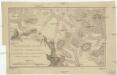
Militairische-Charte vom Mittel-Gebirge in Böheim zwischen Töplitz, Aussig, Bilin und Lowositz
1 : 35000 Bílina-oblast (Česko)
Topographischer Plan zwischen Trebnitz, Millischau und den Kletschen Berg
1 : 15000 Bílka (Bořislav, Česko) Marssovicky
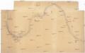
Exerzier-Platz bei Theresienstadt im Jahre 1846
1 : 30800 Terezín-oblast (Litoměřice, Česko)
Unvollendete Topographische Carte von der Position zwischen Aussig und Bilin, und den gegenden gegen abend des Mittelgebürges bis an die Eger bey Laun
České středohoří (Česko : oblast)
Plan de la Bataille de Lobositz le premier octobre Ao 1756
Mollova mapová sbírka Trattner, Johann Thomas von - dílna
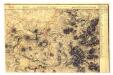
Regni Bohemiae Circulus Litomericensis
1 : 250000 Litoměřice-oblast (Česko) Müller, Johann Christoph ab Homannianis Heredibus
Regni Bohemiae circulus Litomericensis
1 : 180000 Litoměřice-oblast (Česko) Müller, Johann Christoph ab Homannianis Heredibus
Regni Bohemiae Circulus Litomericensis
1 : 250000 Litoměřice-oblast (Česko) Müller, Johann Christoph ab Homannianis Heredibus
Regni Bohemiae circulus Litomericensis
1 : 180000 Litoměřice-oblast (Česko) Müller, Johann Christoph ab Homannianis Heredibus