Maps of Budyně nad Ohří

Gradkartenblatt
1 : 25000 Louny-oblast (Česko) Bellschan, Anton
[Kartenblatt]
1 : 25000 Libochovice (Česko : oblast) Reichsamt für Landesaufnahme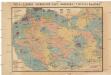
Čeňka Zahálky geologické mapy Podřipska
1 : 25000 Podřipsko (Česko) Zahálka, Čeněk
Gradkartenblatt
1 : 25000 Roudnice nad Labem-oblast (Česko) Bellschan, Anton
III. vojenské mapování 3852/1
1 : 25000
[Kartenblatt]
1 : 25000 Brozany nad Ohří (Česko) Reichsamt für Landesaufnahme
III. vojenské mapování 3852/2
1 : 25000
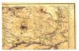
Plan der Gegend von Budin auf 3 Stund in der Länge, und 1/2 Stund in der Breite
1 : 61000 Budyně nad Ohří (Česko) Turati
Exerzier-Platz bei Theresienstadt im Jahre 1846
1 : 30800 Terezín-oblast (Litoměřice, Česko)
Plan de la Bataille de Lobositz le premier octobre Ao 1756
Mollova mapová sbírka Trattner, Johann Thomas von - dílna
Unvollendete Topographische Carte von der Position zwischen Aussig und Bilin, und den gegenden gegen abend des Mittelgebürges bis an die Eger bey Laun
České středohoří (Česko : oblast)
Das sächsische Lager
Lovosice-oblast (Česko)
Brozan - c0532-1-001 - Kaiserpflichtexemplar der Landkarten des stabilen Katasters
1 : 2880
Brozan - c0532-1-005 - Kaiserpflichtexemplar der Landkarten des stabilen Katasters
1 : 2880
Brozan - c0532-1-004 - Kaiserpflichtexemplar der Landkarten des stabilen Katasters
1 : 2880
Brozan - c0532-1-003 - Kaiserpflichtexemplar der Landkarten des stabilen Katasters
1 : 2880
Brozan - c0532-1-006 - Kaiserpflichtexemplar der Landkarten des stabilen Katasters
1 : 2880
Brozan - c0532-1-002 - Kaiserpflichtexemplar der Landkarten des stabilen Katasters
1 : 2880
Budin (Budine) - c0647-1-006 - Kaiserpflichtexemplar der Landkarten des stabilen Katasters
1 : 2880
Budin (Budine) - c0647-1-004 - Kaiserpflichtexemplar der Landkarten des stabilen Katasters
1 : 2880
Budin (Budine) - c0647-1-002 - Kaiserpflichtexemplar der Landkarten des stabilen Katasters
1 : 2880
Budin (Budine) - c0647-1-005 - Kaiserpflichtexemplar der Landkarten des stabilen Katasters
1 : 2880
Budin (Budine) - c0647-1-003 - Kaiserpflichtexemplar der Landkarten des stabilen Katasters
1 : 2880
Budin (Budine) - c0647-1-001 - Kaiserpflichtexemplar der Landkarten des stabilen Katasters
1 : 2880
Libochowitz (Libochowic) - c4036-1-004 - Kaiserpflichtexemplar der Landkarten des stabilen Katasters
1 : 2880
Libochowitz (Libochowic) - c4036-1-002 - Kaiserpflichtexemplar der Landkarten des stabilen Katasters
1 : 2880
Libochowitz (Libochowic) - c4036-1-001 - Kaiserpflichtexemplar der Landkarten des stabilen Katasters
1 : 2880
Libochowitz (Libochowic) - c4036-1-003 - Kaiserpflichtexemplar der Landkarten des stabilen Katasters
1 : 2880


