Maps of okres Litoměřice

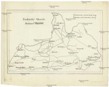
Budyňský vikariát
Budyně nad Ohří-oblast (Česko)
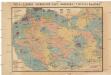
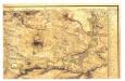
Mapa politického a školního okresu Roudnického
1 : 100000 Roudnice nad Labem-oblast (Česko) Okresní výbor školní
Raudnitz und Juncferteinitz.
from Spezialkarte der osterreichisch-ungarischen Monarchie.
Roudnice n. Labem
1 : 75000 Roudnice nad Labem (Česko : oblast) Vojenský zeměpisný ústav
Soubor přehledných map pro plánování a statistiku: 3852 – Roudnice n. Labem

Soubor přehledných map pro plánování a statistiku: 3852 – Roudnice n. Labem
Mapy plánování ČSR

III. vojenské mapování 3852
1 : 75000
Raudnitz und Jungferteinitz
1 : 75000 Roudnice nad Labem (Česko : oblast) Ahl K. u. k. militär-geographisches Institut
Raudnitz und Jungferteinitz
1 : 75000 Roudnice nad Labem (Česko : oblast) Ahl K. u. k. Militärgeographisches Institut
Raudnitz und Jungferteinitz
1 : 75000 Roudnice nad Labem (Česko : oblast) K. u. k. Militärgeographisches Institut
Okresní hejtmanství Roudnické
Roudnice nad Labem-oblast (Česko)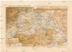
Mapa okres. hejtmanství Roudnického
1 : 100000 Budyně nad Ohří-oblast (Česko) R. Kaška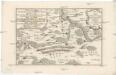
Lager der kayserl. könig. ungarischen Armée bey Budin in Böhmen von der Schlacht bey Lowositz Anno 1756
Budyně nad Ohří-oblast (Česko)
Vilímkovy místopisné mapy zemí Koruny české
1 : 100000 Louny (Česko : oblast) Srp, Jan Jos. R. Vilímek
Bodenkarte des Bezirkes Raudnitz a. d. E
1 : 46000 Roudnice nad Labem-oblast (Česko) Janovský, Josef reprodukce zeměpisného ústavu min. vnitra
Půdní mapa okresu Roudnice nad Labem

Lager der Kaÿserl. Königl. Ungarischen Armée beÿ Budin in Böhmen vor der Schlacht beÿ Lowositz Anno 1756
Mollova mapová sbírka Fridrich, Jacob Andreas Friedrich, Jacob Andreas
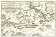
Podrobné mapy zemí Koruny české v měřítku 1:75.000 a mapa vzdáleností všech míst při silnici ležících - Velvary - Slaný - Kralupy. Průvodce statisticko-historický po všech místech na těchto mapách uvedených a rejstřík věcný názvů hor, potoků, řek, rybníků atd/ Sešit 12. List 40,
1 : 75000
Podrobné mapy zemí Koruny české v měřítku 1:75.000 a mapa vzdáleností všech míst při silnici ležících
1 : 75000 Kralupy nad Vltavou-oblast (Česko) Bělohlav, Josef Kučera, Karel F. Topič

Gradkartenblatt
1 : 25000 Roudnice nad Labem-oblast (Česko) Bellschan, Anton
Gradkartenblatt
1 : 25000 Louny-oblast (Česko) Bellschan, Anton
[Kartenblatt]
1 : 25000 Brozany nad Ohří (Česko) Reichsamt für Landesaufnahme
[Kartenblatt]
1 : 25000 Libochovice (Česko : oblast) Reichsamt für Landesaufnahme
III. vojenské mapování 3852/1
1 : 25000
III. vojenské mapování 3852/2
1 : 25000