Maps of Kralupy nad Vltavou

Eisenbahn Karte Wien-Dresden, Ollmütz-Trübau
1 : 72000 Blatt 14 Minarzik, Anselm J. Rauh
Velvary a okolí
1 : 75000 Velvary (Česko : oblast) Vojenský zeměpisný ústav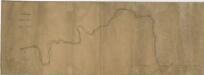
Schema des Moldau - Flusses von Prag bis Melnik

Verbindungs-Dreiecke der Grundlinie zwischen dem Lorenz- und Georgenberge mit der trigonometrischen Vermessung der Gegend um Neuschloss
Petřín (Praha, Česko)

[Náčrt původní Buštěhradské dráhy]
Buštěhradská dráha (Česko : zaniklá železniční trať)

Bodenkarte des Bezirkes Raudnitz a. d. E
1 : 46000 Roudnice nad Labem-oblast (Česko) Janovský, Josef reprodukce zeměpisného ústavu min. vnitra

[Praha a okolí]
Praha-oblast (Česko)
Podrobné mapy zemí Koruny české v měřítku 1:75.000 a mapa vzdáleností všech míst při silnici ležících
1 : 75000 Kralupy nad Vltavou-oblast (Česko) Bělohlav, Josef Kučera, Karel F. Topič
Podrobné mapy zemí Koruny české v měřítku 1:75.000 a mapa vzdáleností všech míst při silnici ležících - Velvary - Slaný - Kralupy. Průvodce statisticko-historický po všech místech na těchto mapách uvedených a rejstřík věcný názvů hor, potoků, řek, rybníků atd/ Sešit 12. List 40,
1 : 75000
Mapa okresu smíchovského v Pražském kraji = Karte des Smichower Bezirkes im Prager Kreise : podle nejnovějších a nejbezpečnějších pramenů sestavena a vydána k založení obecních knihoven ve veškerých okresích kraje Pražského

Soubor map okresů Pražského kraje

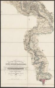
Karte des Welwarner Bezirkes im Prager Kreise
1 : 72400 Velvary-oblast (Česko) Wagner, Jan Eduard Karl André
Karte des Welwarner Bezirkes im Prager Kreise
1 : 72400 Velvary-oblast (Česko) Wagner, Jan Eduard Karl André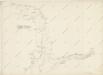
Hydrografische Uibersichtskarte der Flüsse, Bäche und sonstigen Gewässer im Königreiche Boehmen

III. vojenské mapování 3852/4
1 : 25000
III. vojenské mapování 3952/2
1 : 25000
III. vojenské mapování 3952/2
1 : 25000
Gradkartenblatt
1 : 25000 Velvary-oblast (Česko) Albrecht, Julius
Plan der Gegend zwischen Tursko und Theresienstadt
1 : 61500 Budyně nad Ohří-oblast (Česko)
Plan der Gegend zwischen Kletzan und Weltrus
1 : 47500 Klecany (Česko) Schwihlik, F.
Plan der Gegend zwischen Kletzan und Weltrus
1 : 48000 Klecany (Česko) Adam
Půdní mapa okresu Roudnice nad Labem

Výškopisný plán hlavního města Prahy s okolím

Výškopisný plán hlavního města Prahy s okolím

Lager in der Gegend vom Georgen-Berg
1 : 100000 Říp (Česko : hora : oblast)
Okolí Mělníka a Kralup n. V
1 : 25000 Kralupy nad Vltavou-oblast (Česko) Nešvera, P. Plesinger, Václav P. Nešvera a V. Plesinger
Lager bey Weldruss
1 : 62000 Veltrusy (Česko)