Maps of Kladno

[Náčrt původní Buštěhradské dráhy]
Buštěhradská dráha (Česko : zaniklá železniční trať)
Mapa Prahy a okolí
1 : 66000
Pragae metropolis regni Bohemiae cum adjacentibus terris accurata descriptio geographica
1 : 60000 cura et studio Matth. Seutter Aug. Vindel : M. Seutter
Umgebung von Prag
Praha-oblast (Česko) Biller, Bernhardt Marco Berra
Velká Praha a okolí
Plan der Battaille welche d. 6. Maj zwischen der kayserlich-königlich-ungarischen und königlich preussischen Armée bey Prag geliefert worden, 1757
Praha (Česko)
[Praha a okolí]
Praha-oblast (Česko)
Gradkartenblatt
1 : 25000 Čechy (Česko) Czechák, Carl
III. vojenské mapování 3953/1
1 : 25000
III. vojenské mapování 3953/1
1 : 25000
III. vojenské mapování 3952/2
1 : 25000
III. vojenské mapování 3952/2
1 : 25000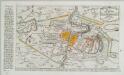
Plan der Battaille welche d. 6. Maj zwischen den Kayserl. Königl. Ungarische[n] u. Königlich Preusische[n] Armee bey Prag geliefert worden. 1757
1 : 90000
Soubor map okresů Pražského kraje

Mapa politického a školního okresu Karlínského

Karte des Karolinenthaler Bezirkes im Prager Kreise
1 : 72000 Karlín (Praha, Česko) Wagner, Jan Eduard in Commission bei Karl André
Karte des Karolinenthaler Bezirkes im Prager Kreise
1 : 72000 Karlín (Praha, Česko) Wagner, Jan Eduard Karl André
Karte des Karolinenthaler Bezirkes im Prager Kreise
1 : 72000 Karlín (Praha, Česko) Wagner, Jan Eduard in Commission bei Karl André
Karte des Karolinenthaler Bezirkes im Prager Kreise
1 : 72000 Karlín (Praha, Česko) Wagner, Jan Eduard in Commission bei Karl André
Karte des Karolinenthaler Bezirkes im Prager Kreise
1 : 72000 Karlín (Praha, Česko) Wagner, Jan Eduard in Commission bei Karl André
Praha a okolí
Praha (Česko : oblast) Kuchař, Karel
Mapa okresu smíchovského v Pražském kraji = Karte des Smichower Bezirkes im Prager Kreise : podle nejnovějších a nejbezpečnějších pramenů sestavena a vydána k založení obecních knihoven ve veškerých okresích kraje Pražského

Soubor map okresů Pražského kraje
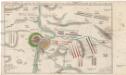
Accurate Vorstellung der zwischen den oesterreichischen und preussischen Armeen geschehenen Bataille bey Prag, den 6. May 1757
Praha (Česko)
Výškopisný plán hlavního města Prahy s okolím
1 : 20000 Praha (Česko) obec Pražská
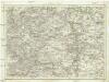
Podrobné mapy zemí Koruny české v měřítku 1:75.000 - Smečno - Kladno - Unhošť. Průvodce statisticko-historický po všech místech na těchto mapách uvedených a rejstřík věcný názvů hor, potoků, řek, rybníků atd. a mapa vzdáleností všech míst při silnici ležících Sešit 4. List 41,
1 : 75000
Regulační plán Velké Prahy s okolím
1 : 50000
Karte des Smichower Bezirkes im Prager Kreise
1 : 70000 Praha-oblast (Česko) Wagner, Jan Eduard Karl André
![[Náčrt původní Buštěhradské dráhy]](https://images-0.georeferencer.com/images/iiif/889569256736/full/,300/0/native.jpg)

