Maps of Klecany

Karte des Karolinenthaler Bezirkes im Prager Kreise
1 : 72000 Karlín (Praha, Česko) Wagner, Jan Eduard in Commission bei Karl André
Karte des Karolinenthaler Bezirkes im Prager Kreise
1 : 72000 Karlín (Praha, Česko) Wagner, Jan Eduard Karl André
Karte des Karolinenthaler Bezirkes im Prager Kreise
1 : 72000 Karlín (Praha, Česko) Wagner, Jan Eduard in Commission bei Karl André
Karte des Karolinenthaler Bezirkes im Prager Kreise
1 : 72000 Karlín (Praha, Česko) Wagner, Jan Eduard in Commission bei Karl André
Karte des Karolinenthaler Bezirkes im Prager Kreise
1 : 72000 Karlín (Praha, Česko) Wagner, Jan Eduard in Commission bei Karl André
Soubor map okresů Pražského kraje

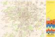
Výškopisný plán hlavního města Prahy s okolím
1 : 20000 Praha (Česko) obec Pražská
Recht wahrhaffte Vorstellung der den 6ten May A.no 1757 zwischen der kaisserl. und könig. preüss. Armée bey Prag vorgefallenen Bataille
Praha (Česko) Salzer, Ignác
Recht wahrhaffte Vorstellung der den 6ten May A.no 1757 zwischen der kasserl. und könig. preüss. Armée bey Prag vorgefallenen Bataille
Praha (Česko) Salzer, Ignác
Recht wahrhaffte Vorstellung der den 6ten May A.no 1757 zwischen der kaisserl. und könig. preüss. Armée bey Prag vorgefallenen Bataille
Praha (Česko) Salzer, Ignác
[Gradkartenblatt]
1 : 25000 Praha (Česko : oblast) Vojenský zeměpisný ústav
Les environs de Prague
1 : 31000 Praha (Česko)
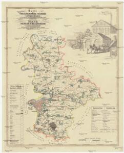
Mapa politického a školního okresu Karlínského
Jižní Město. - Litochleby Orientační plán 3. souboru
1 : 2500
Nový, úředně schválený plán Velké Prahy
1 : 25000
Uliční mapa hlavního města Prahy

Bez titulu: Jihovýchodní okolí Prahy
Jižní Město. - Háje Orientační plán 1. souboru
1 : 3500
Gradkartenblatt
1 : 25000 Čechy (Česko) Czechák, Carl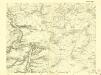
III. vojenské mapování 3953/1
1 : 25000
III. vojenské mapování 3953/1
1 : 25000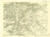
III. vojenské mapování 3953/3
1 : 25000
Plan de la Bataille... le 6 May 1757

Přehledná mapa Velké Prahy
1 : 35000 Praha (Česko : oblast) Brož, Josef A. Storch syn
Orientační plán Hlavního města Prahy

Plán velké Prahy
1 : 19000 Praha (Česko) Grgurič, Václav Sádlo, Jiří A. Storch syn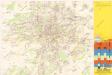
Jižní Město. - Opatov Orientační plán 2. souboru
1 : 2500
Schlacht bei Prag, den 6-ten May 1757

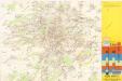
Výškopisný plán hlavního města Prahy s okolím