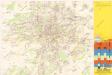
Maps of Dejvice

[Gradkartenblatt]
1 : 25000 Praha (Česko : oblast) Vojenský zeměpisný ústav
Bez titulu: Jihovýchodní okolí Prahy
Jižní Město. - Opatov Orientační plán 2. souboru
1 : 2500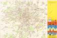
Jižní Město. - Háje Orientační plán 1. souboru
1 : 3500
III. vojenské mapování 3953/3
1 : 25000
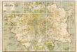
Přehledná mapa Velké Prahy
1 : 35000 Praha (Česko : oblast) Brož, Josef A. Storch syn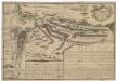
Recht wahrhaffte Vorstellung der den 6ten May A.no 1757 zwischen der kaisserl. und könig. preüss. Armée bey Prag vorgefallenen Bataille
Praha (Česko) Salzer, Ignác
Recht wahrhaffte Vorstellung der den 6ten May A.no 1757 zwischen der kasserl. und könig. preüss. Armée bey Prag vorgefallenen Bataille
Praha (Česko) Salzer, Ignác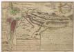
Recht wahrhaffte Vorstellung der den 6ten May A.no 1757 zwischen der kaisserl. und könig. preüss. Armée bey Prag vorgefallenen Bataille
Praha (Česko) Salzer, Ignác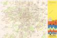
Jižní Město. - Litochleby Orientační plán 3. souboru
1 : 2500
Výškopisný plán hlavního města Prahy s okolím
1 : 20000 Praha (Česko) obec Pražská
Nový, úředně schválený plán Velké Prahy
1 : 25000
Uliční mapa hlavního města Prahy

Plan van de stadt en de beleegering van Praag, 1757 = Plan de la ville & du siege de Prague, en 1757
T. Otten sc. ['s-Gravenhage] : P. Gosse excudit
Die öffentlichen Verkehrsmittel der Hauptstadt Prag
1 : 17500 Praha (Česko) Městské podniky pražské
Plán velké Prahy
1 : 19000 Praha (Česko) Grgurič, Václav Sádlo, Jiří A. Storch syn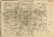
Auto-Praha : automobilní plán Velké Prahy a příručka pro automobilisty
1 : 50000
Městské podniky Pražské
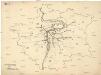
[Praha - projekt podzemní a nadzemní dráhy].
Praha (Česko) Poláček, K. Wallenfels, F.
[Praha - projekt podzemní dráhy]
Praha (Česko)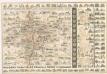
Praha : názorné plány a rejstřík

Bataille de Prague
1 : 62300 Praha (Česko) Therbu Coentgen, Heinrich Hugo
Plán Velké Prahy
1 : 19000
Orientační plán hlavního města Prahy s okolím
Orientační plán hlavního města Prahy
1 : 14000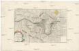
Belagerung und Bloquade der Stadt Prag durch die königl. preussische Armée, im Jahre 1757
Praha (Česko)
Hlavní město Praha
1 : 55000 Praha (Česko)
Přehledná mapa Velké Prahy : [s průvodcem a popisem všech obcí v ní zahrnutých] : [odpolední výlety po okolí pražském]
1 : 34725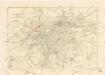
Plán sběrného okruhu a dopravních spojů pro motorová vozidla

![[Gradkartenblatt]](https://images-2.georeferencer.com/images/iiif/872182945368/full/,300/0/native.jpg)

