Maps of Kladno

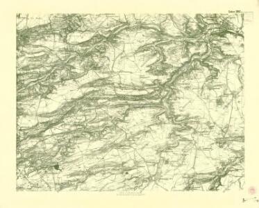
III. vojenské mapování 3952/2
1 : 25000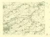
III. vojenské mapování 3952/2
1 : 25000
PLAN DES Tuchomeirzitzer, Cizoniczer, Strzedokluker und Russiner Revieres
1 : 3000 Tuchoměřice (Česko)
Liditz (Lýdic) - c4074-1-002 - Kaiserpflichtexemplar der Landkarten des stabilen Katasters
1 : 2880
Liditz (Lýdic) - c4074-1-006 - Kaiserpflichtexemplar der Landkarten des stabilen Katasters
1 : 2880
Liditz (Lýdic) - c4074-1-005 - Kaiserpflichtexemplar der Landkarten des stabilen Katasters
1 : 2880
Liditz (Lýdic) - c4074-1-003 - Kaiserpflichtexemplar der Landkarten des stabilen Katasters
1 : 2880
Liditz (Lýdic) - c4074-1-004 - Kaiserpflichtexemplar der Landkarten des stabilen Katasters
1 : 2880
Liditz (Lýdic) - c4074-1-001 - Kaiserpflichtexemplar der Landkarten des stabilen Katasters
1 : 2880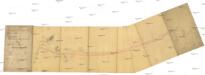
Podružná dráha z Minkovic do Zvoleňovse
1 : 1000 Kamenný Most (Česko)
Kladno

Kladno

Území Lidice - okres Kladno

Wottwowitz (Wottwowic) - c5602-1-003 - Kaiserpflichtexemplar der Landkarten des stabilen Katasters
1 : 2880
Wottwowitz (Wottwowic) - c5602-1-004 - Kaiserpflichtexemplar der Landkarten des stabilen Katasters
1 : 2880
Wottwowitz (Wottwowic) - c5602-1-001 - Kaiserpflichtexemplar der Landkarten des stabilen Katasters
1 : 2880
Wottwowitz (Wottwowic) - c5602-1-002 - Kaiserpflichtexemplar der Landkarten des stabilen Katasters
1 : 2880
Pher - c5761-1-001 - Kaiserpflichtexemplar der Landkarten des stabilen Katasters
1 : 2880
Pher - c5761-1-002 - Kaiserpflichtexemplar der Landkarten des stabilen Katasters
1 : 2880
Pher - c5761-1-004 - Kaiserpflichtexemplar der Landkarten des stabilen Katasters
1 : 2880
Pher - c5761-1-005 - Kaiserpflichtexemplar der Landkarten des stabilen Katasters
1 : 2880
Pher - c5761-1-007 - Kaiserpflichtexemplar der Landkarten des stabilen Katasters
1 : 2880
Pher - c5761-1-006 - Kaiserpflichtexemplar der Landkarten des stabilen Katasters
1 : 2880
Pher - c5761-1-003 - Kaiserpflichtexemplar der Landkarten des stabilen Katasters
1 : 2880
Steltschowes (Stelčowes) - c7329-1-002 - Kaiserpflichtexemplar der Landkarten des stabilen Katasters
1 : 2880
Steltschowes (Stelčowes) - c7329-1-005 - Kaiserpflichtexemplar der Landkarten des stabilen Katasters
1 : 2880
Steltschowes (Stelčowes) - c7329-1-001 - Kaiserpflichtexemplar der Landkarten des stabilen Katasters
1 : 2880
Steltschowes (Stelčowes) - c7329-1-004 - Kaiserpflichtexemplar der Landkarten des stabilen Katasters
1 : 2880
Steltschowes (Stelčowes) - c7329-1-003 - Kaiserpflichtexemplar der Landkarten des stabilen Katasters
1 : 2880
Dubi (Duby) - c1591-1-004 - Kaiserpflichtexemplar der Landkarten des stabilen Katasters
1 : 2880
Dubi (Duby) - c1591-1-002 - Kaiserpflichtexemplar der Landkarten des stabilen Katasters
1 : 2880
Dubi (Duby) - c1591-1-003 - Kaiserpflichtexemplar der Landkarten des stabilen Katasters
1 : 2880