Maps of Prague

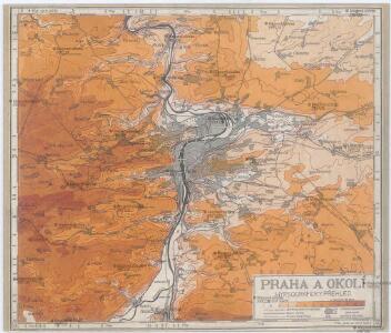
Praha a okolí
Praha (Česko : oblast) Kuchař, Karel
Velká Praha a okolí

Přesná nivelace Velké Prahy s okolím : [přehled nivelačních tratí a osazených výškových bodů]
1 : 25000
[Umgebungen der königl. Hauptstadt Prag]
1 : 45000 Praha-oblast (Česko) Basdar
Umgebung der königl. Hauptstadt Prag
Praha-oblast (Česko) Heber, Franz Alexander Berra, Marco Marco Berra
Regulační plán Velké Prahy s okolím
1 : 50000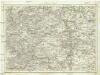
Umgebung von Prag
Praha-oblast (Česko) Biller, Bernhardt Marco Berra
[Mapa okolí pražského]
Praha-oblast (Česko)
[Mapa okolí pražského]
Praha-oblast (Česko)
Mapa okolí pražského
Praha-oblast (Česko)
Trigonometrische Netz der Umgebungen von der königlichen Hauptstadt Prag
1 : 90000 Praha-oblast (Česko) Jüttner, Josef
Plan der koniglichen Hauptstadt Prag mit den naechsten Umgebungen
Praha-oblast (Česko) Kral, Anton
Spezialkarte der Umgebung von Prag

Pražský vikariát
Praha-oblast (Česko)
Pragae metropolis regni Bohemiae cum adjacentibus terris accurata descriptio geographica
1 : 60000 cura et studio Matth. Seutter Aug. Vindel : M. Seutter
Mapa Prahy a okolí
1 : 66000
[Prag und Umgebung]
1 : 57600 Praha (Česko) Carl Bellmann's Verlag
Praha - městská hromadná doprava
1 : 40000
Výškopisný plán hlavního města Prahy s okolím
1 : 20000 Praha (Česko) obec Pražská
Podrobné mapy zemí Koruny české v měřítku 1:75.000 a mapa vzdáleností všech míst při silnici ležících
1 : 75000 Brandýs nad Labem-Stará Boleslav (Česko : oblast) Bělohlav, Josef F. Topič
Belagerung der königlicher Haupt-Stadt Prag...
Plan der Battaille welche d. 6. Maj zwischen den Kayserl. Königl. Ungarische[n] u. Königlich Preusische[n] Armee bey Prag geliefert worden. 1757
1 : 90000
[Praha a okolí]
Praha-oblast (Česko)
Plan der Battaille welche d. 6. Maj zwischen der kayserlich-königlich-ungarischen und königlich preussischen Armée bey Prag geliefert worden, 1757
Praha (Česko)
Jižní Město. - Litochleby Orientační plán 3. souboru
1 : 2500
Belagerung der Königl. Haupt-Stadt Prag
1 : 57000 Berounka (Česko) Werner, Bedřich Bernard Strahowsky, B.
Nový, úředně schválený plán Velké Prahy
1 : 25000
Soubor map okresů Pražského kraje

Podrobné mapy zemí koruny české v měřítku 1:75 000 a průvodce statisticko-historický po všech místech na těchto mapách uvedených. - Praha-Brandýs n. L. List 55
1 : 75000