Maps of Praha

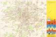
[Praha a okolí]
Praha-oblast (Česko)
Pragae metropolis regni Bohemiae cum adjacentibus terris accurata descriptio geographica
1 : 60000 cura et studio Matth. Seutter Aug. Vindel : M. Seutter
Velká Praha a okolí

Soubor map okresů Pražského kraje

Mapa okresu smíchovského v Pražském kraji = Karte des Smichower Bezirkes im Prager Kreise : podle nejnovějších a nejbezpečnějších pramenů sestavena a vydána k založení obecních knihoven ve veškerých okresích kraje Pražského

[Mapa okolí pražského]
Praha-oblast (Česko)
[Mapa okolí pražského]
Praha-oblast (Česko)
Mapa okolí pražského
Praha-oblast (Česko)
Umgebung der königl. Hauptstadt Prag
Praha-oblast (Česko) Heber, Franz Alexander Berra, Marco Marco Berra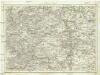
Umgebung von Prag
Praha-oblast (Česko) Biller, Bernhardt Marco Berra
Praha a okolí
Praha (Česko : oblast) Kuchař, Karel
Belagerung der königlicher Haupt-Stadt Prag...

Karte des Smichower Bezirkes im Prager Kreise
1 : 70000 Praha-oblast (Česko) Wagner, Jan Eduard Karl André
Belagerung der Königl. Haupt-Stadt Prag
1 : 57000 Berounka (Česko) Werner, Bedřich Bernard Strahowsky, B.
Spezialkarte der Umgebung von Prag

Přesná nivelace Velké Prahy s okolím : [přehled nivelačních tratí a osazených výškových bodů]
1 : 25000
[Umgebungen der königl. Hauptstadt Prag]
1 : 45000 Praha-oblast (Česko) Basdar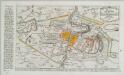
Plan der Battaille welche d. 6. Maj zwischen den Kayserl. Königl. Ungarische[n] u. Königlich Preusische[n] Armee bey Prag geliefert worden. 1757
1 : 90000
Regulační plán Velké Prahy s okolím
1 : 50000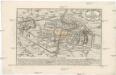
Plan der Battaille welche d. 6. Maj zwischen der kayserlich-königlich-ungarischen und königlich preussischen Armée bey Prag geliefert worden, 1757
Praha (Česko)
Výškopisný plán hlavního města Prahy s okolím
1 : 20000 Praha (Česko) obec Pražská
Praha - městská hromadná doprava
1 : 40000
Prag's Umgebungen
Praha-oblast (Česko) Scheiner, Josef Kettner, C. J.G. Calve'sche Buchhandlung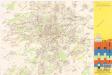
Jižní Město. - Litochleby Orientační plán 3. souboru
1 : 2500
Verbesserter Grundriß der königl. bohmischen Haupt Stadt Prag mit der königl. ungarschen Belagerung und Attaquen A 1742
Praha (Česko) Riegel, Christoph bey Christoph Riegel
Grundriß der königl. bohmischen Haupt Stadt Prag mit der königl ungarschen Belagerung und Attaquen A 1742
Praha (Česko)

Nový, úředně schválený plán Velké Prahy
1 : 25000
Specielle Telegrafen und Eisenbahn Karte von Böhmen
![[Praha a okolí]](https://images-2.georeferencer.com/images/iiif/150748162768/full/,300/0/native.jpg)

