Maps of Nusle
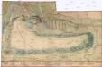
[Plán Vyšehradu]
Braník (Praha, Česko)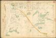
Auto-Praha : automobilní plán Velké Prahy a příručka pro automobilisty
1 : 50000
Orientační plán hlavního města Prahy s okolím

Orientační plán Prahy a obcí sousedních List 21.

Orientační plán hlavního města Prahy s okolím
1 : 5000
Podoll - c5920-1-002 - Kaiserpflichtexemplar der Landkarten des stabilen Katasters
1 : 2880
Podoll - c5920-1-001 - Kaiserpflichtexemplar der Landkarten des stabilen Katasters
1 : 2880
Nussle - c5330-1-002 - Kaiserpflichtexemplar der Landkarten des stabilen Katasters
1 : 2880
Nussle - c5330-1-001 - Kaiserpflichtexemplar der Landkarten des stabilen Katasters
1 : 2880
Unter Krtsch (Dolnj Krtč) - c1314-1-001 - Kaiserpflichtexemplar der Landkarten des stabilen Katasters
1 : 2880
Unter Krtsch (Dolnj Krtč) - c1314-1-002 - Kaiserpflichtexemplar der Landkarten des stabilen Katasters
1 : 2880
Orientační plán Prahy a obcí sousedních List 22.
1 : 5000
Ober Krtsch (Hornj Krtč) - c2072-1-002 - Kaiserpflichtexemplar der Landkarten des stabilen Katasters
1 : 2880
Ober Krtsch (Hornj Krtč) - c2072-1-001 - Kaiserpflichtexemplar der Landkarten des stabilen Katasters
1 : 2880
Orientační plán města Nuslí

Regulační plán spojených obcí Nusle a Pankrác

Orientační plán král. Hl. města Prahy

Výškopisný plán hlavního města Prahy s okolím

Orientační plán hlavního města Prahy s okolím

Orientační plán hlavního města Prahy s okolím
1 : 5000
Stabilní katastr - Procovní otisk Krč Dolní

Plan von Wischehrad
Vyšehrad (Praha, Česko) Bittner, Joseph Pluth, Caspar
Abbildung deß weitberümbten Pragerischen allten Schlosses Wiserat, wie solches von ihr kayserl. und königl. May. Ferdi. III Ao. 1653 zu fortificiren angefangen, und von ihr kön. May. Leopoldo I. durch he. Obristen Joseph Priamii Freihe. von Rouorat, he. auf Lichna vollführet würt
Vyšehrad (Praha, Česko) Merian, Matthaeus M. Merian
Polohopisný plán královského hlavního města Prahy

Plan der Haupstadt Prag 18; 19
Praha, hlavní město ČSR : Fastrův obrázkový plán a průvodce
1 : 10000
Stavební parcely na vily a rodinné domy v Praze XV. - Lhotce-Zátiší na rozhraní Krče a Braníka se rozprodají
Braník (Praha, Česko) Vojenský zeměpisný ústav
Grundtriss der Prager Stätte

Plan des südlichen Moldauthal ́s bei Prag

![[Plán Vyšehradu]](https://images-2.georeferencer.com/images/iiif/262026437670/full/,300/0/native.jpg)

