Maps of Vršovice
Polohopisný plán královského hlavního města Prahy

Polohopisný plán Královských Vinohradů, Vršovic a Nuslí
1 : 4000 Nusle (Praha, Česko) Hurtig, Alfred F. Kytka
Monumentální plán královského města Prahy

Polohopisný plán Kr. Vinohradů, Nuslí a Vršovic
1 : 4000
Situations-Plan Kgl. Weinberge, Nusle und Vršovic
Přehledný regulační plán města Vršovic
Vršovice (Praha, Česko) Zdeněk, Jaroslav Šimáček, Josef
Orientační plán města Vršovic
1 : 2880
Wrschowitz - c8866-1-001 - Kaiserpflichtexemplar der Landkarten des stabilen Katasters
1 : 2880
Wrschowitz - c8866-1-002 - Kaiserpflichtexemplar der Landkarten des stabilen Katasters
1 : 2880
Wrschowitz - c8866-1-003 - Kaiserpflichtexemplar der Landkarten des stabilen Katasters
1 : 2880
Orientační plán král. Hl. města Prahy

Orientační plán hlavního města Prahy s okolím

Orientační plán hlavního města Prahy s okolím
1 : 5000
[Praha-Nové Město]
Praha (Česko) Vasquez Pinos, Karl Weiss, Fr.
Město Král. Vinohrady

Město Král. Vinohrady
Vinohrady (Praha, Česko) Srp, Jan Trávníček, František
Orientační plán měst Král. Vinohrad, Nuslí a Vršovic
1 : 5760 Nusle (Praha, Česko) Herold, Theofil České lidové knihkupectví a antikvariát (Jos. Springer)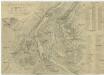
Grundriss der k. k. Hauptstadt Prag und ihres nächtigen Umgebungen
1 : 15000 Praha (Česko) Wöllner, Leopold Pluth, Caspar
Grundriss der k. k. Hauptstadt Prag und ihres nächtigen Umgebungen
1 : 15000 Praha (Česko) Wöllner, Leopold Pluth, Caspar
Praha autoplán

Praha autoplán

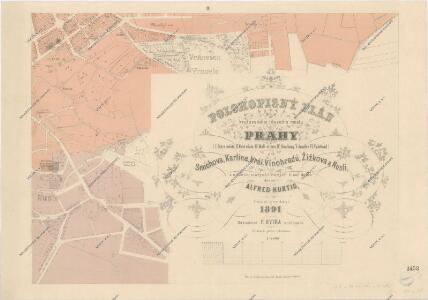
Plán Prahy, Karlína, Smíchova, Vyšehradu, Žižkova, Král. Vinohradů a nejbližšího okolí
1 : 20000 Praha (Česko) Brož, Josef Šimáček, Josef A. Felkl
Plan von Prag und Umgebung 1874
1 : 14600 Praha (Česko) Kořistka, Karel František Edvard Verlag der statistichsen Kommission der königl. Haupstadt Prag
Plán kr. hl. města Prahy s vůkolím 1874
1 : 14600 Praha (Česko) Kořistka, Karel František Edvard náklad statistické kommisse kr. hl. m. Prahy
Plán kr. hl. města Prahy s vůkolím 1874
1 : 14600 Praha (Česko : oblast) Kořistka, Karel František Edvard Statistická kommisse
Plan von Prag und Umgebung 1874
1 : 15000 Praha (Česko : oblast) Kořistka, Karel František Edvard Statistische Kommission
Praha autoplán

Nejnovější plán Prahy předměstí a okolí
Praha (Česko) Alois Hynek
Hlavní město Praha
Praha (Česko) Hlávka, Emil Čedok