Maps of Vinohrady

Orientační plán měst Král. Vinohrad, Nuslí a Vršovic
1 : 5760 Nusle (Praha, Česko) Herold, Theofil České lidové knihkupectví a antikvariát (Jos. Springer)
Polohopisný plán Královských Vinohradů, Vršovic a Nuslí
1 : 4000 Nusle (Praha, Česko) Hurtig, Alfred F. Kytka
Polohopisný plán Kr. Vinohradů, Nuslí a Vršovic
1 : 4000
Situations-Plan Kgl. Weinberge, Nusle und Vršovic

Monumentální plán královského města Prahy

Orientační plán král. Hl. města Prahy

Město Král. Vinohrady

Polohopisný plán města Král. Vinohradů

Regulační plán spojených obcí Nusle a Pankrác

[Praha-Nové Město]
Praha (Česko) Vasquez Pinos, Karl Weiss, Fr.
Orientační plán města Nuslí

Nussle - c5330-1-002 - Kaiserpflichtexemplar der Landkarten des stabilen Katasters
1 : 2880
Nussle - c5330-1-001 - Kaiserpflichtexemplar der Landkarten des stabilen Katasters
1 : 2880
Orientační plán města Vršovic
1 : 2880
Orientační plán hlavního města Prahy s okolím

Orientační plán hlavního města Prahy s okolím
1 : 5000
Wrschowitz - c8866-1-001 - Kaiserpflichtexemplar der Landkarten des stabilen Katasters
1 : 2880
Wrschowitz - c8866-1-002 - Kaiserpflichtexemplar der Landkarten des stabilen Katasters
1 : 2880
Wrschowitz - c8866-1-003 - Kaiserpflichtexemplar der Landkarten des stabilen Katasters
1 : 2880
Přehledný regulační plán města Vršovic
Vršovice (Praha, Česko) Zdeněk, Jaroslav Šimáček, Josef
Orientační plán král. Hl. města Prahy

Orientační plán Prahy a obcí sousedních List 16.

Orientační plán Prahy a obcí sousedních List 16.
1 : 5000
Orientační plán Prahy a obcí sousedních List 16.
1 : 5000
Polohopisný plán královského hlavního města Prahy

Město Král. Vinohrady
Vinohrady (Praha, Česko) Srp, Jan Trávníček, František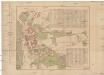
Polohopisný plán města Král. Vinohrady
1 : 3600 Vinohrady (Praha, Česko) Štverák, Jan Josef Fuksa
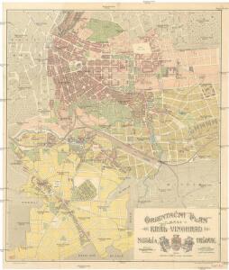
Orientační plán města "Král. Vinohrady"
1 : 2200 Vinohrady (Praha, Česko) Poláček, K. Wallenfels, F. nákladem města Královské Vinohrady
Polohopisný plán královského hlavního města Prahy : 1.Staré město, 2.Nové město, 3.Malá strana, 4.Hradčany, 5.Josefov, 6.Vyšehrad pak Smíchova, Karlína, král.Vinohradů, Žižkova a Nuslí, s udáním starých i nových čísel domů
1 : 4000