Maps of Podolí

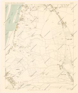
Orientační plán Prahy a obcí sousedních List 21.

Orientační plán hlavního města Prahy s okolím

Orientační plán hlavního města Prahy s okolím
1 : 5000
Podoll - c5920-1-002 - Kaiserpflichtexemplar der Landkarten des stabilen Katasters
1 : 2880
Podoll - c5920-1-001 - Kaiserpflichtexemplar der Landkarten des stabilen Katasters
1 : 2880
Orientační plán král. Hl. města Prahy
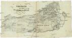
[Plán Vyšehradu]
Braník (Praha, Česko)
Auto-Praha : automobilní plán Velké Prahy a příručka pro automobilisty
1 : 50000
Unter Krtsch (Dolnj Krtč) - c1314-1-001 - Kaiserpflichtexemplar der Landkarten des stabilen Katasters
1 : 2880
Unter Krtsch (Dolnj Krtč) - c1314-1-002 - Kaiserpflichtexemplar der Landkarten des stabilen Katasters
1 : 2880
Branik - c0461-1-002 - Kaiserpflichtexemplar der Landkarten des stabilen Katasters
1 : 2880
Branik - c0461-1-003 - Kaiserpflichtexemplar der Landkarten des stabilen Katasters
1 : 2880
Branik - c0461-1-001 - Kaiserpflichtexemplar der Landkarten des stabilen Katasters
1 : 2880
Nussle - c5330-1-002 - Kaiserpflichtexemplar der Landkarten des stabilen Katasters
1 : 2880
Nussle - c5330-1-001 - Kaiserpflichtexemplar der Landkarten des stabilen Katasters
1 : 2880
Orientační plán města Nuslí

Regulační plán spojených obcí Nusle a Pankrác

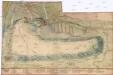
Plan des südlichen Moldauthal ́s bei Prag

Grundtriss der Prager Stätte
Praha, hlavní město ČSR : Fastrův obrázkový plán a průvodce
1 : 10000
Stavební parcely na vily a rodinné domy v Praze XV. - Lhotce-Zátiší na rozhraní Krče a Braníka se rozprodají
Braník (Praha, Česko) Vojenský zeměpisný ústav
Potrubí a situace nové vodárny pražské (vyznačeno červeně)
1 : 14300 Praha (Česko)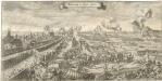
Bestürmbung der Prager Stätte

Orientační plán sídel. hlav. města Prahy
1 : 12000 Libeň (Praha, Česko) M. Král
Bez titulu: Plán hlavního města Prahy

Environs de Hlubočep

Militaerisch Topographischer Plan von der Königl. Hauptstadt Prag nebst Umgebungen

Neuester Plan von Prag mit seiner Umgebungen
1 : 18000 Praha (Česko) bei Gottl. Haase Söhne
Pan von Prag und der nächsten Umgebung
1 : 11520 Praha (Česko) Strnad, Josef Bohemia