Maps of Krč

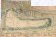
Unter Krtsch (Dolnj Krtč) - c1314-1-001 - Kaiserpflichtexemplar der Landkarten des stabilen Katasters
1 : 2880
Unter Krtsch (Dolnj Krtč) - c1314-1-002 - Kaiserpflichtexemplar der Landkarten des stabilen Katasters
1 : 2880
Stabilní katastr - Procovní otisk Krč Dolní
[Plán Vyšehradu]
Braník (Praha, Česko)
Situační plán stavebních pozemků velkostatku Nový Dvůr u Krče
Nový Dvůr (Praha, Česko) Kebort, I. Neudörfl, Josef Věnceslav Vojenský zeměpisný ústav
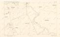
Branik - c0461-1-002 - Kaiserpflichtexemplar der Landkarten des stabilen Katasters
1 : 2880
Branik - c0461-1-003 - Kaiserpflichtexemplar der Landkarten des stabilen Katasters
1 : 2880
Branik - c0461-1-001 - Kaiserpflichtexemplar der Landkarten des stabilen Katasters
1 : 2880
Ober Krtsch (Hornj Krtč) - c2072-1-002 - Kaiserpflichtexemplar der Landkarten des stabilen Katasters
1 : 2880
Ober Krtsch (Hornj Krtč) - c2072-1-001 - Kaiserpflichtexemplar der Landkarten des stabilen Katasters
1 : 2880
Orientační plán Prahy a obcí sousedních List 21.

Orientační plán hlavního města Prahy s okolím

Orientační plán hlavního města Prahy s okolím
1 : 5000
Orientační plán hlavního města Prahy s okolím
1 : 5000
Výškopisný plán hlavního města Prahy s okolím

Orientační plán Prahy a obcí sousedních List 22.
1 : 5000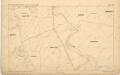
Orientační plán král. Hl. města Prahy
Orientační plán Prahy a obcí sousedních List 29.
1 : 5000
Stavební parcely na vily a rodinné domy v Praze XV. - Lhotce-Zátiší na rozhraní Krče a Braníka se rozprodají
Braník (Praha, Česko) Vojenský zeměpisný ústav
Grundtriss der Prager Stätte
Orientierungsplan der Hauptstadt Prag
Jiřík, Rudolf
Plan des südlichen Moldauthal ́s bei Prag
Praha, hlavní město ČSR : Fastrův obrázkový plán a průvodce
1 : 10000
Environs de Hlubočep
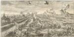
Bestürmbung der Prager Stätte

Potrubí a situace nové vodárny pražské (vyznačeno červeně)
1 : 14300 Praha (Česko)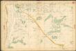
Auto-Praha : automobilní plán Velké Prahy a příručka pro automobilisty
1 : 50000
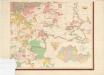
Michle - c4623-1-001 - Kaiserpflichtexemplar der Landkarten des stabilen Katasters
1 : 2880
Michle - c4623-1-004 - Kaiserpflichtexemplar der Landkarten des stabilen Katasters
1 : 2880
Michle - c4623-1-002 - Kaiserpflichtexemplar der Landkarten des stabilen Katasters
1 : 2880


