Maps of Vinohrady

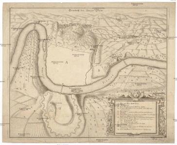
Grundriß der Prager Stätte
Praha (Česko)
[Praha]
1 : 61500 Praha (Česko) Basdar, von
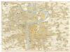
Plán Prahy a obcí sousedních
Praha (Česko) Hurtig, Alfred Neudörfl, Jaroslav Jos. R. Vilímek
Plan of Prague
1 : 16000 V. Neubert a Synové V. Neubert a Synové
Nové tratě elektrických drah hlav. města Prahy
Pharusův plán král. hlav. města Prahy
1 : 11500
Plán královského hlavního města Prahy s okolím
Praha (Česko) Brož, Josef Grefnetter, Josef B. Rácová
Praha : informační plán
1 : 15000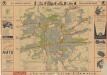
Praha
Prag
1 : 16000 Praha (Česko) Grgurič, V. Vilím, Jan Čedok
Orientační plán hlavního města Prahy
1 : 15000
Praha : [II. celostátní spartakiáda 1960]
1 : 15000
Plán královského hlavního města Prahy

Pharusův plán hlav. města Prahy
1 : 14000 Praha (Česko) Löwe, Cornelius K. André
Plán stanic a pásem sítě elektr. drah hlavního města Prahy
Praha (Česko)
Kriegs-Expeditions-Karte in Böhmen I. Blatt, in welchem die Haubtstadt Prag mit der Französsischen und Saechsischen Belageruug und Eroberung, so den 26. Novembre 1741 geschehen, vorgestellet wird
1 : 21000 Praha (Česko) Homann Erben
Plán tratí elektrických drah král. Hlav. Města Prahy

Podrobný plán Hlavního města Prahy

Praha : [II. celostátní spartakiáda 1960]
1 : 15000
Plan de la ville de Prague, capitale du royaume de Boheme, assiegée par les troupes Hongroisses et Autrichiennes en l'an 1742
Praha (Česko)
Velký příruční plán hlav. města Prahy
1 : 12000 Praha (Česko) Brož, Josef A. Storch syn
Plán král. hlav. města Prahy a obcí sousedních
1 : 12000 Praha (Česko) Brož, Josef A. Storch syn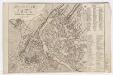
Grundriß des K. K. Hauptstadt Prag und ihres nächsten Umgebungen
Wöltner, Leop [s.n.]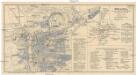
Praha
Praha (Česko) Salač, Klement Metzeroth, Carl B. Kočí
Bez titulu: Plán hlavního města Prahy

[Plán Prahy]
Praha (Česko)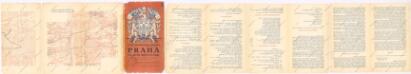
Praha, hlavní město ČSR : Fastrův obrázkový plán a průvodce
1 : 10000
Přehled tratí elektrických drah král. hlav. města Prahy

Orientační plán Prahy