Maps of Smíchov

Plán královského hlavního města Prahy s okolím
Praha (Česko) Brož, Josef Grefnetter, Josef B. Rácová
Plán královského hlavního města Prahy

Velký příruční plán hlav. města Prahy
1 : 12000 Praha (Česko) Brož, Josef A. Storch syn
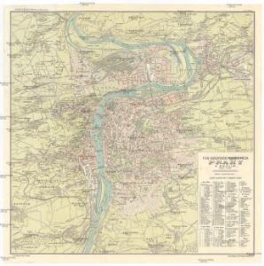
Plán král. hlav. města Prahy a obcí sousedních
1 : 12000 Praha (Česko) Brož, Josef A. Storch syn
Síť kanalisace Prahy
Praha (Česko)
Prag
1 : 16000 Praha (Česko) Grgurič, V. Vilím, Jan Čedok
Kriegs-Expeditions-Karte in Böhmen I. Blatt, in welchem die Haubtstadt Prag mit der Französsischen und Saechsischen Belageruug und Eroberung, so den 26. Novembre 1741 geschehen, vorgestellet wird
1 : 21000 Praha (Česko) Homann Erben
Plán král. hlav. města Prahy a obcí sousedních
1 : 12000
Praha : orientační plán
1 : 15000
Plán král. Hlav. Města Prahy a obcí sousedních

Síť kanalisace Prahy

Praha : orientační plán : Československá spartakiáda 1975
1 : 15000
Praha : [II. celostátní spartakiáda 1960]
1 : 15000
Praha : [II. celostátní spartakiáda 1960]
1 : 15000
Plán královského hlavního města Velké Prahy s okolím
1 : 20000 Praha (Česko : oblast) Brož, Josef Šolc a Šimáček
Plán královského hlavního města Velké Prahy s okolím
1 : 20000 Praha (Česko) Brož, Josef B. Racová
Plán tratí elektrických drah král. Hlav. Města Prahy

Bez titulu: Plán Prahy

Plán Prahy a obcí sousedních
Praha (Česko) Hurtig, Alfred Neudörfl, Jaroslav Jos. R. Vilímek
Plán význačných novostaveb pražských 1919-1934
Praha (Česko) Mánes
Carte de Prague
1 : 83500 Praha (Česko) Brequin Birckhart, C.
Plán král. hlav. města Prahy a obcí sousedních
1 : 12000 Brož, Josef, 1844-1930 nákladem A. Štorcha Syna
Orientační plán hlavního města Prahy

[Praha]
Praha (Česko) Včela
Praha : informační plán
1 : 15000
Plán sítě autobusů hl. m. Prahy

Praha

Praha, hlavní město ČSR : Fastrův obrázkový plán a průvodce
1 : 10000
Orientační automobilový plán velké Prahy
Praha (Česko) Poláček, K. Wallenfels, F. cestovní oddělení Autoklubu Republiky Československé