Maps of Smíchov

Plán královského hlavního města Prahy

Plán královského hlavního města Prahy s okolím
Praha (Česko) Brož, Josef Grefnetter, Josef B. Rácová
Velký příruční plán hlav. města Prahy
1 : 12000 Praha (Česko) Brož, Josef A. Storch syn
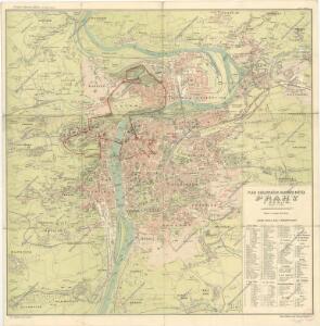
Plán král. hlav. města Prahy a obcí sousedních
1 : 12000 Praha (Česko) Brož, Josef A. Storch syn
Síť kanalisace Prahy
Praha (Česko)
Plán král. hlav. města Prahy a obcí sousedních
1 : 12000
Plán král. Hlav. Města Prahy a obcí sousedních

Kriegs-Expeditions-Karte in Böhmen I. Blatt, in welchem die Haubtstadt Prag mit der Französsischen und Saechsischen Belageruug und Eroberung, so den 26. Novembre 1741 geschehen, vorgestellet wird
1 : 21000 Praha (Česko) Homann Erben
Praha : orientační plán
1 : 15000
Síť kanalisace Prahy

Prag
1 : 16000 Praha (Česko) Grgurič, V. Vilím, Jan Čedok
Praha : orientační plán : Československá spartakiáda 1975
1 : 15000
Plán královského hlavního města Velké Prahy s okolím
1 : 20000 Praha (Česko : oblast) Brož, Josef Šolc a Šimáček
Plán královského hlavního města Velké Prahy s okolím
1 : 20000 Praha (Česko) Brož, Josef B. Racová
Praha : [II. celostátní spartakiáda 1960]
1 : 15000
Bez titulu: Plán Prahy

Plán král. hlav. města Prahy a obcí sousedních
1 : 12000 Brož, Josef, 1844-1930 nákladem A. Štorcha Syna
Plán tratí elektrických drah král. Hlav. Města Prahy

Praha : [II. celostátní spartakiáda 1960]
1 : 15000
Plán význačných novostaveb pražských 1919-1934
Praha (Česko) Mánes
Orientační plán hlavního města Prahy

Plán sítě autobusů hl. m. Prahy

Orientační automobilový plán velké Prahy
Praha (Česko) Poláček, K. Wallenfels, F. cestovní oddělení Autoklubu Republiky Československé
[Praha]
Praha (Česko) Včela
Ichnographia et orthographia metropolis Pragensis
1 : 7200 Praha (Česko)
Ichnographia et orthographia metropolis Pragensis
1 : 7200 Praha (Česko)
Ichnographia et orthographia metropolis Pragensis
1 : 7200 Praha (Česko)
Carte de Prague
1 : 83500 Praha (Česko) Brequin Birckhart, C.
Praha, hlavní město ČSR : Fastrův obrázkový plán a průvodce
1 : 10000