Maps of Smíchov

Kurtze doch wahrhaffte Nachricht was waehrend der- durch dem im Jahr 1757. beschehenen Preußischen gewaltsamen Einfall in allhiesiges Koenigreich Boeheim, erlittenen sechswochentlichen harten Belagerung der koenigl. Haupt- und Residenz Stadt Prag, sich zugetragen
Praha (Česko) Breyer, Johanes Nepomuk Salzer, Ignác
Nejnovější plán Prahy s okolím
Holešovice (Praha, Česko) Brož, Josef Alois Hynek
Okolí Pražské

Praha : informační plán
1 : 15000
Orientační plán hlavního města Prahy
1 : 15000
Militærisch topographischer Plan von der königl. Hauptstadt Prag nebst Umgebungen

Praha

[Plán Prahy]
Praha (Česko)
Prag
1 : 16000 Praha (Česko) Grgurič, V. Vilím, Jan Čedok
Praha : [II. celostátní spartakiáda 1960]
1 : 15000
Praha

Praha
Praha (Česko) Salač, Klement Metzeroth, Carl B. Kočí
Militaerisch topographischer Plan von der königl. Hauptstadt Prag nebst Umgebungen
1 : 11600 Praha (Česko) Berra, Marco Artaria et Comp.
Kriegs-Expeditions-Karte in Böhmen I. Blat, in welchem die Haubtstadt Prag mit der französsischen und saechsischen Belageru[n]g und Eroberung, so den 26. Novembre 1741. geschehen, vorgestellet wird
1 : 20700 Praha (Česko) Meyer Sinsart von Homaen[n] Erben
Kriegs-Expeditions-Karte in Böhmen I. Blat, in welchem die Haubtstadt Prag mit der französsischen und saechsischen Belageru[n]g und Eroberung, so den 26. Novembre 1741. geschehen, vorgestellet wird
1 : 20700 Praha (Česko) Meyer Sinsart von Homaen[n] Erben
Praha : [II. celostátní spartakiáda 1960]
1 : 15000
Velký příruční plán hlav. města Prahy
1 : 12000 Praha (Česko) Brož, Josef A. Storch syn
Plán král. hlav. města Prahy a obcí sousedních
1 : 12000 Praha (Česko) Brož, Josef A. Storch syn
Plán tratí elektrických drah král. Hlav. Města Prahy

Okolí pražské
Praha (Česko) Hurtig, Alfred Seybold, I.
Král. hlavní město Praha s okolím r. 1848
1 : 10000 Praha (Česko)
Orientační plán hlavního města Prahy

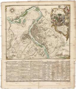
Plan der Stadt Prag mit denen umliegenden Gegenden wie es von der preussischen Armée unter comando des Königs von Preussen und des Feld Mareschal Keith von den 8 May biss den 19 Juny 1757 ist belagert worden
1 : 168000 Praha (Česko) Prasser, Baptist bey Herrn Baptist Prasser
Síť kanalisace Prahy
Praha (Česko)
Praha : orientační plán
1 : 15000
Ichnographia et orthographia metropolis Pragensis
1 : 7200 Praha (Česko)
Ichnographia et orthographia metropolis Pragensis
1 : 7200 Praha (Česko)
Ichnographia et orthographia metropolis Pragensis
1 : 7200 Praha (Česko)
Bez titulu: Plán Prahy