Maps of Dejvice

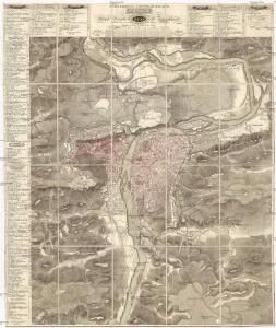
Militaerisch topographischer Plan von der königl. Hauptstadt Prag nebst Umgebungen
1 : 11600 Praha (Česko) Berra, Marco Artaria et Comp.
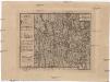
Okolí pražské
Praha (Česko) Hurtig, Alfred Seybold, I.
Ichnographia et orthographia metropolis Pragensis
1 : 7200 Praha (Česko)
Ichnographia et orthographia metropolis Pragensis
1 : 7200 Praha (Česko)
Ichnographia et orthographia metropolis Pragensis
1 : 7200 Praha (Česko)
Orientační plán hlavního města Prahy

[Plán Prahy]
Praha (Česko)
Bez titulu: Plán Prahy

Plan der Stadt Prag mit denen umliegenden Gegenden wie es von der preussischen Armée unter comando des Königs von Preussen und des Feld Mareschal Keith von den 8 May biss den 19 Juny 1757 ist belagert worden
1 : 168000 Praha (Česko) Prasser, Baptist bey Herrn Baptist Prasser
Okolí Pražské

Plan des environs de Prague : et des camps des deux armées dedié a Mgr. Le Prince de Soubise
1 : 20000 Le Rouge, Georges-Louis Le Rouge
Síť kanalisace Prahy

Plán královského hlavního města Velké Prahy s okolím
1 : 20000 Praha (Česko : oblast) Brož, Josef Šolc a Šimáček
Plán královského hlavního města Velké Prahy s okolím
1 : 20000 Praha (Česko) Brož, Josef B. Racová
Plan des environs de Prague et des camps des deux armées
1 : 20700 Praha (Česko) Le Rouge, Georges-Louis Soubise, Charles de Rohan le Rouge
Praha : [II. celostátní spartakiáda 1960]
1 : 15000
Prag
1 : 16000 Praha (Česko) Grgurič, V. Vilím, Jan Čedok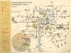
Plán sítě elektrických drah hlvního města Prahy
Carte de Prague
1 : 83500 Praha (Česko) Brequin Birckhart, C.
Plan der Königlischen Hauptstadt Prag
Praha (Česko) Sommer, Lorenz
Síť kanalisace Prahy
Praha (Česko)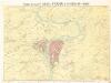
Král. Hlavní město Praha s okolím r. 1848.

Orientační automobilový plán Velké Prahy
Praha (Česko) Poláček, K. Wallenfels, F. cestovní oddělení Autoklubu Republiky Československé
Militærisch topographischer Plan von der königl. Hauptstadt Prag nebst Umgebungen

Praha : informační plán
1 : 15000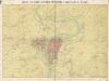
Královské hlavní město Praha s okolím r. 1848
Král. hlavní město Praha s okolím r. 1848

Praha : [II. celostátní spartakiáda 1960]
1 : 15000
Praha : orientační plán : Československá spartakiáda 1975
1 : 15000