Maps of Dejvice

Plán sítě elektrických drah hlvního města Prahy

Nejnovější plán Prahy : připojen abecední seznam ulic k rychlému vyhledávání, seznam škol...
1 : 17500
Prag und seine Umgebungen
Praha (Česko) Bittner, Joseph Kettner, C. J. G. Calvesche Buchhandlung
Orientační plán hlavního města Prahy
Praha (Česko) Brož, Josef Stein, Carl Průmyslová tiskárna
Die öffentlichen Verkehrsmittel der Hauptstadt Prag
Praha (Česko)
Veřejné dopravní prostředky hlavního města Prahy

Orientační plán Prahy a obcí sousedních přehledka

Plán sítě elektrických drah, trolejbusů a autobusů hlavního města Prahy

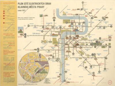
Plán sítě elektrických drah hlavního města Prahy

Blocus de Prague
1 : 106600 Praha (Česko) Therbu Coentgen, Heinrich Hugo
Přehledná mapa velké Prahy

Přehledná mapa Velké Prahy : [s průvodcem a popisem všech obcí v ní zahrnutých] : [odpolední výlety po okolí pražském]
1 : 34725
Plán sběrného okruhu a dopravních spojů pro motorová vozidla

Zu Bildner des Heeres Beilage 9
1 : 63000 Praha-oblast (Česko) K.k. Schulbücher-Verschleiss-Administration
Praha : plán města
1 : 20000
Auto-Praha : automobilní plán Velké Prahy a příručka pro automobilisty
1 : 50000
Specielle Telegrafen und Eisenbahn Karte von Böhmen

Plan des environs de Prague : et des camps des deux armées dedié a Mgr. Le Prince de Soubise
1 : 20000 Le Rouge, Georges-Louis Le Rouge
Plán král. hlav. města Prahy a obcí sousedních
1 : 12000 Brož, Josef, 1844-1930 nákladem A. Štorcha Syna
[Praha - projekt podzemní a nadzemní dráhy].
Praha (Česko) Poláček, K. Wallenfels, F.
[Praha - projekt podzemní dráhy]
Praha (Česko)
Prag und seine Umgebungen, nach den besten Hülfsmitteln dargestellt
1 : 42000 C. Kettner sculp. Prag : J. G. Calve'sche Buchhandlung
Orientační plán hlavního města Prahy
1 : 14000
Plán Velké Prahy
1 : 19000
Plán sítě autobusů hl. m. Prahy

Hlavní město Praha
1 : 55000 Praha (Česko)
Okolí města Prahy na hodinu cesty
Praha-oblast (Česko) K. Hübner
Grundriss der könig. böhmische[n] Haupt Stadt Prag
Praha (Česko)
[Praha a okolí]
Praha-oblast (Česko)