Maps of Dejvice

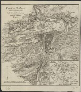
Prag und seine Umgebungen, nach den besten Hülfsmitteln dargestellt
1 : 42000 C. Kettner sculp. Prag : J. G. Calve'sche Buchhandlung
Okolí města Prahy na hodinu cesty
Praha-oblast (Česko) K. Hübner
Specielle Telegrafen und Eisenbahn Karte von Böhmen

Plán Velké Prahy
1 : 19000
Praha : názorné plány a rejstřík

Přehledná mapa Velké Prahy
1 : 35000 Praha (Česko : oblast) Brož, Josef A. Storch syn
Prag und seine Umgebungen
Praha (Česko) Bittner, Joseph Kettner, C. J. G. Calvesche Buchhandlung
Plan van de stadt en de beleegering van Praag, 1757 = Plan de la ville & du siege de Prague, en 1757
T. Otten sc. ['s-Gravenhage] : P. Gosse excudit
Grundriss der könig. böhmische[n] Haupt Stadt Prag
Praha (Česko)
Orientační plán hlavního města Prahy s okolím

Hlavní město Praha
1 : 55000 Praha (Česko)
Nejnovější plán Prahy : připojen abecední seznam ulic k rychlému vyhledávání, seznam škol...
1 : 17500
Jižní Město. - Opatov Orientační plán 2. souboru
1 : 2500
Prag's Umgebungen
Praha-oblast (Česko) Scheiner, Josef Kettner, C. J.G. Calve'sche Buchhandlung
Uliční mapa hlavního města Prahy

Plán velké Prahy
1 : 19000 Praha (Česko) Grgurič, Václav Sádlo, Jiří A. Storch syn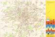
Jižní Město. - Háje Orientační plán 1. souboru
1 : 3500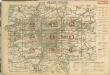
Auto-Praha : automobilní plán Velké Prahy a příručka pro automobilisty
1 : 50000
Blocus de Prague
1 : 106600 Praha (Česko) Therbu Coentgen, Heinrich Hugo
Nový, úředně schválený plán Velké Prahy
1 : 25000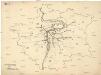
[Praha - projekt podzemní a nadzemní dráhy].
Praha (Česko) Poláček, K. Wallenfels, F.
[Praha - projekt podzemní dráhy]
Praha (Česko)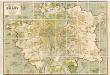
Orientační plán hlavního města Prahy
1 : 14000
Grundriss der König. Bohmischen Haupt Stadt Prag
Praha (Česko) Christoph Riegel Buchhändlen
Okolí Prahy
1 : 25000 Praha (Česko : oblast) Hurtig, Alfred Stát. komise
Přehledná mapa Velké Prahy : [s průvodcem a popisem všech obcí v ní zahrnutých] : [odpolední výlety po okolí pražském]
1 : 34725
Plan der Hauptstadt Prag und der umliegenden Gegend sammt dem Lustlager der kais. königl. Armée
1 : 47500 Praha (Česko)
Plan der Hauptstadt Prag und der umliegenden Gegend sammt dem Lustlager der kais. königl. Armée
1 : 47500 Praha (Česko)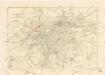
Plán sběrného okruhu a dopravních spojů pro motorová vozidla