Maps of Germany

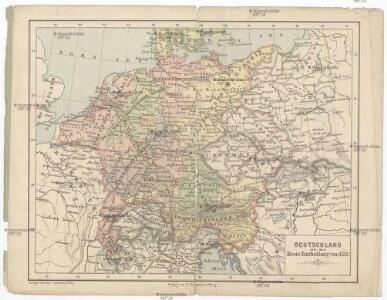
Deutschland mit der Kreis-Eintheilung von 1512
Evropa střední Benecke Bormann, E. F. Tempsky
[Mitteleuropa]
1 : 2500000 [S.l. : s.n.]
German Empire.
1 : 2150000 Faden, William, 1750?-1836
German Empire.
1 : 2150000 Faden, William, 1750?-1836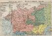
Mitteleuropa. Völker
1 : 9000000 Mitteleuropa Ethnische Gruppe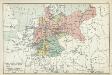
XII. Preußen innerhalb Deutschlands mit den angrenzenden Staatengebieten
1 : 6000000 Mitteleuropa, Deutschland
Post- und Eisenbahn-Reisekarte von Central-Europa
1 : 2000000 Evropa střední Franz, J. Handtke, Friedrich Carl Flemming
Telegrafenlinien, Eisenbahnen und Dampfbootfahrten in Deutschland und den Nachbarstaaten
Evropa střední Raffelsperger, Franz Franz Raffelsperger
Tabula Moderna Germanie [Karte], in: Claudii Ptolemei viri Alexandrini mathematice discipline philosophi doctissimi geographie opus [...], S. 245.
1 Karte aus Atlas Waldseemüller, Martin [und Ptolemaeus, Claudius] Übelin, Georg
Mitteleuropa
1 : 3500000 Evropa střední Köcher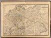
Composite: Allemagne.
1 : 2000000 Andriveau-Goujon, J.
Mitteleuropa am Ende des 30 jährigen Krieges
Evropa střední F. Tempsky
Post und Eisenbahn Reisekarte von Central Europa

Deutsches Reich. Niederlande, Belgien & Schweiz
Adolf Stieler's Handatlas über alle Theile der Erde und über das Weltgebäude Stieler, Adolf Justus Perthes
Germany.
1 : 6000000 Finley, Anthony
R.A. Schulz's neue praktische Reise-Karte mit Angabe der Distanzen
Evropa střední Schulz, R. A. Biller, Dominik Artaria & Co.
R.A. Schulz's neue praktische Reise-Karte mit Angabe der Distanzen
Evropa střední Schulz, R. A. Artaria & Co.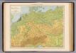
Deutschland physikalisch.
1 : 3400000 Andree, Richard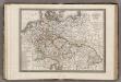
Allemagne.
1 : 5000000 Monin, C.V.
Karte des Deutschen Reichs
Schmidt, Johann Marius Friedrich; Jäck Schropp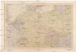
Střední Evropa
1 : 4500000 Evropa střední V. Neubert a synové
Eisenbahnkarte von Mittel Europa
1 : 3375000 Berlín (Německo) Broditzky, Joseph R. v. Waldheim
Eisenbahnkarte von Mittel Europa
1 : 3375000 Berlín (Německo) Broditzky, Joseph R. v. Waldheim
Eisenbahnkarte von Mittel Europa
1 : 3375000 Berlín (Německo) Broditzky, Joseph R. v. Waldheim
Eisenbahnkarte von Mittel Europa
1 : 3375000 Berlín (Německo) Broditzky, Joseph R. v. Waldheim
Eisenbahnkarte von Mittel Europa
1 : 3375000 Berlín (Německo) Broditzky, Joseph R. v. Waldheim
Autriche, Prusse, Confed. Germanique, Pologne 1788 a 1841.
1 : 6300000 Houze, Antoine Philippe
Mitteleuropa während des 30 jährigen Krieges.
Evropa střední Benecke Bormann, E. F. Tempsky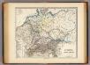
Germania, Raetia, Noricum.
1 : 3800000 Menke, Th.