Maps of Germany
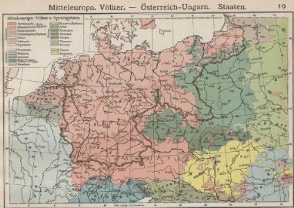
Mitteleuropa. Völker
1 : 9000000 Mitteleuropa Ethnische Gruppe
[Mitteleuropa]
1 : 2500000 [S.l. : s.n.]
Deutschland mit der Kreis-Eintheilung von 1512
Evropa střední Benecke Bormann, E. F. Tempsky
Karte des Deutschen Reichs
Schmidt, Johann Marius Friedrich; Jäck Schropp
Composite: Allemagne.
1 : 2000000 Andriveau-Goujon, J.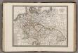
Allemagne.
1 : 5000000 Monin, C.V.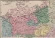
Das Sprachgebiet der Deutschen in Mitteleuropa
1 : 7500000 Mitteleuropa Deutsche, Sprachkartografie
Germany.
1 : 6000000 Finley, Anthony
Autriche, Prusse, Confed. Germanique, Pologne 1788 a 1841.
1 : 6300000 Houze, Antoine Philippe
Mitteleuropa am Ende des 30 jährigen Krieges
Evropa střední F. Tempsky
Telegrafenlinien, Eisenbahnen und Dampfbootfahrten in Deutschland und den Nachbarstaaten
Evropa střední Raffelsperger, Franz Franz Raffelsperger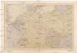
Střední Evropa
1 : 4500000 Evropa střední V. Neubert a synové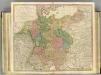
German Empire.
1 : 2150000 Faden, William, 1750?-1836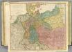
German Empire.
1 : 2150000 Faden, William, 1750?-1836
Sprachkarte von Deutschland
1 : 3000000 Evropa střední Bernhardt, Karl Bohné, J. J. von J.J. Bohné
Mitteleuropa während des 30 jährigen Krieges.
Evropa střední Benecke Bormann, E. F. Tempsky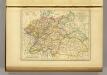
l'Allemagne par Cercles in 1789.
1 : 6300000 Malte-Brun, Conrad, 1775-1826
Politisch-statistische Charte von Deutschland nebst dem grössten Theile von Pohlen, einem grossen Theile von Frankreich und Nord-Italien
1 : 2900000 Evropa střední Champion, J. N. Baumann, J. Mitzky & Comp.
Post- und Eisenbahn-Reisekarte von Central-Europa
1 : 2000000 Evropa střední Franz, J. Handtke, Friedrich Carl Flemming
Tabula Moderna Germanie [Karte], in: Claudii Ptolemei viri Alexandrini mathematice discipline philosophi doctissimi geographie opus [...], S. 245.
1 Karte aus Atlas Waldseemüller, Martin [und Ptolemaeus, Claudius] Übelin, Georg
Allemagne. Politique et économique. n133
1 : 2600000 A. Taride Paris : A.Taride
Mitteleuropa
1 : 3500000 Evropa střední Köcher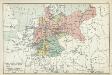
XII. Preußen innerhalb Deutschlands mit den angrenzenden Staatengebieten
1 : 6000000 Mitteleuropa, Deutschland
Deutschland, Übersicht des Deutschen Reichs
Handatlas über alle Theile der Erde und über das Weltgebäude Stieler, Adolf Justus Perthes
Střední Evropa v zájmu světového míru
1 : 5000000 Evropa střední Kuffner, Hanuš
Deutschland
Neuer Handatlas über alle Theile der Erde Kiepert, Heinrich Verlag von Dietrich Reimer
Regenkarte, Mittlere Jahrestemperatur v. Deutschland.
1 : 7000000 Andree, Richard
Sprachenkarte, Religionskarte v. Deutschland.
1 : 7000000 Andree, Richard
Hohenschichtenkarte, Bevolkerungsdichtigkeit.
1 : 7000000 Andree, Richard
Post- & Reise-Karte von Deutschland und den nachbar Staaten
Evropa střední Handtke, Friedrich Flemming, C. C. Flemming