Maps of Germany

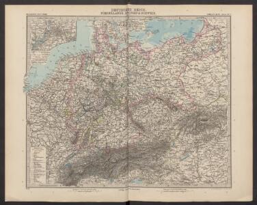
Deutsches Reich. Niederlande, Belgien & Schweiz
Adolf Stieler's Handatlas über alle Theile der Erde und über das Weltgebäude Stieler, Adolf Justus Perthes
Tabula Moderna Germanie [Karte], in: Claudii Ptolemei viri Alexandrini mathematice discipline philosophi doctissimi geographie opus [...], S. 245.
1 Karte aus Atlas Waldseemüller, Martin [und Ptolemaeus, Claudius] Übelin, Georg
Special-karte von Deutschland: nebst einem Theile der angrenzenden Länder mit Gesonderer Berücksichtigung der Gebirge und Gewässer
Fried, Franz
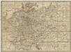
Deutschland
Allgemeiner Atlas [Walch, Johannes] im Verlag bei Johannes Walch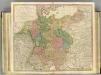
German Empire.
1 : 2150000 Faden, William, 1750?-1836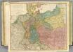
German Empire.
1 : 2150000 Faden, William, 1750?-1836
Deutschland
E. von Sydow's Schul-Atlas in sechs und dreissig Karten Sydow, Emil von bei Justus Perthes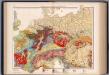
Mitteleuropa, Geologische Übersicht
1 : 3500000 Scobel, Albert
Reise-Karte von Mittel-Europa : mit Angabe der Bahnstationen und Postverbindungen / nach den neuesten Quellen entw. u. gezeichnet. von M. Hermann
1 : 2800000 Annotatie: Bijlage bij: J.C. König und Erhardt's Tages-Notizbuch Hermann, M. [S.l. : s.n.] / (Glogau : Flemming)
Mitteleuropa
1 : 3500000 Evropa střední Köcher
Střední Evropa v zájmu světového míru
1 : 5000000 Evropa střední Kuffner, Hanuš
R.A. Schulz's neue praktische Reise-Karte mit Angabe der Distanzen
Evropa střední Schulz, R. A. Biller, Dominik Artaria & Co.
R.A. Schulz's neue praktische Reise-Karte mit Angabe der Distanzen
Evropa střední Schulz, R. A. Artaria & Co.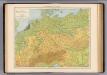
Deutschland physikalisch.
1 : 3400000 Andree, Richard
Deutschland, Niederlande, Belgien und Schweiz
Schul-Atlas über alle Theile der Erde nach dem neuesten Zustande, und über das Weltgebäude Stieler, Adolf Justus Perthes
Deutschland um 1500
Deutschland Kunz, Andreas ; Moeschl, Joachim Robert
Deutschland 1555
Deutschland Kunz, Andreas ; Moeschl, Joachim Robert
R.A. Schulz's neue praktische Reise-Karte mit Angabe der Distanzen
Anglie Schulz, R. A. Biller, Dominik Artaria
Fluss- u. Gebirgs-Karte, Mittel-Europa.
1 : 4500000 Flemming, Carl
Neueste Eisenbahn-Karte von Central-Europa
1 : 1900000 Evropa střední Hendschel, U. Carl Jügel
Fluss- und Gebirgs-Karte von Mittel-Eüropa
1 : 4900000 Evropa střední Handtke, Friedrich C. Flemming
Post- Reise-Karte durch Deutschland und die angraenzenden Staaten zwischen London und Lublin, Koppenhagen und Mantua
Evropa střední Schmidt, O. F. Schropp, Simon Simon Schropp & Comp.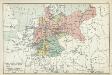
XII. Preußen innerhalb Deutschlands mit den angrenzenden Staatengebieten
1 : 6000000 Mitteleuropa, Deutschland
Deutschland 1648
Deutschland Kunz, Andreas ; Moeschl, Joachim Robert
Post- und Eisenbahn-Reisekarte von Central-Europa
1 : 2000000 Evropa střední Franz, J. Handtke, Friedrich Carl Flemming
Mitteleuropa am Ende des 30 jährigen Krieges
Evropa střední F. Tempsky
Post und Eisenbahn Reisekarte von Central Europa

Prussia, and the German States.
from New general atlas.
Mitteleuropa während des 30 jährigen Krieges.
Evropa střední Benecke Bormann, E. F. Tempsky