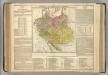
Maps of Germany

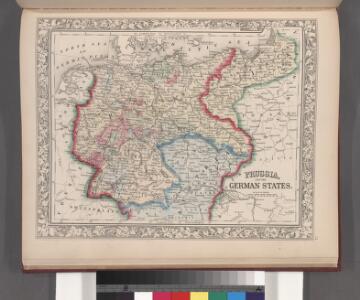
Prussia, and the German States.
from New general atlas.
Karte der Heilquellen und Kurorte von Mittel - Europa

Střední Evropa v době náboženské reformace a protireformace 1517 - 1648

R.A. Schulz's neue praktische Reise-Karte mit Angabe der Distanzen
Anglie Schulz, R. A. Biller, Dominik Artaria
Fluss- u. Gebirgs-Karte, Mittel-Europa.
1 : 4500000 Flemming, Carl
Mitteleuropa
1 : 8000000 Evropa střední Kocen, Blaž Eduard Hölzel
R.A. Schulz's neue praktische Reise-Karte mit Angabe der Distanzen
Evropa střední Schulz, R. A. Biller, Dominik Artaria & Co.
R.A. Schulz's neue praktische Reise-Karte mit Angabe der Distanzen
Evropa střední Schulz, R. A. Artaria & Co.
Eisenbahn-Übersichtskarte von Mittel-Europa
Evropa R. v. Waldheim
Neue Ausgabe von Schulz's praktischer Reise-Karte mit Angabe der Distanzen und Eisenbahnen
Evropa střední Schulz, R. A. Artaria & Co.
Karte der floss- und schiffbaren Flüsse von Mittel-Europa
1 : 3000000 Evropa střední Jelussig, Othmar Kiepert, Heinrich
Geogr.-physik.-statist. Karte von Deutschland mit Einschluss von ganz Oesterreich, Belgien, den Niederlanden, der Schweiz, Italien und einem Theile von Frankreich, England, Russland und der Türkei
1 : 4000000 Evropa střední Haurand, Theodor C. W.
Eisenbahnkarte von Mittel Europa
1 : 3375000 Berlín (Německo) Broditzky, Joseph R. v. Waldheim
Eisenbahnkarte von Mittel Europa
1 : 3375000 Berlín (Německo) Broditzky, Joseph R. v. Waldheim
Eisenbahnkarte von Mittel Europa
1 : 3375000 Berlín (Německo) Broditzky, Joseph R. v. Waldheim
Eisenbahnkarte von Mittel Europa
1 : 3375000 Berlín (Německo) Broditzky, Joseph R. v. Waldheim
Eisenbahnkarte von Mittel Europa
1 : 3375000 Berlín (Německo) Broditzky, Joseph R. v. Waldheim
Übersichtskarte der Verbreitung der Deutschen in Europa
Evropa Kiepert, Heinrich Haas, František Dietrich Reimer
2. Pyrenäenfriede 1659
1 : 30000000 Mitteleuropa Pyrenäenfriede
[Centralis Europae]
Evropa střední Schedel, Hartmann
Eisenbahnkarte von Mitteleuropa
German Empire.
1 : 6200000 Lavoisne, M.
Post roads Germany, Hungary.
1 : 2500000 Robert Laurie & James Whittle
Porostní mapa revíru Srbice
1 : 2880
Carte élémentaire et statistique de l'Allemagne
1 : 2700000 Brion de La Tour, Louis Brion & Maire
Central-Europa
Mitteleuropa
Deutschlands geschichtlich geographischer Zeitraum von 158 v. Chr. bis 260 n. Chr
Evropa střední Ehrenkreutz, I. V.
Sbírka map a diagramů použitých na mírových konferencích v Paříži v letech 1919 - 1920

Eisenbahn-Übersichtskarte von Mittel-Europa
Evropa R. v. Waldheim
Eisenbahn-Übersichtskarte von Mittel-Europa
Evropa R. v. Waldheim
Eisenbahn-Übersichtskarte von Mittel-Europa
Evropa