Maps of Germany

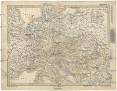
Mitteleuropa
1 : 8000000 Evropa střední Kocen, Blaž Eduard Hölzel
Eisenbahnkarte von Mitteleuropa

Střední Evropa v době náboženské reformace a protireformace 1517 - 1648
So wollten unsere Feinde Europa nach dem Kriege gestalten
Karte der floss- und schiffbaren Flüsse von Mittel-Europa
1 : 3000000 Evropa střední Jelussig, Othmar Kiepert, Heinrich
Karte der Heilquellen und Kurorte von Mittel - Europa

Geogr.-physik.-statist. Karte von Deutschland mit Einschluss von ganz Oesterreich, Belgien, den Niederlanden, der Schweiz, Italien und einem Theile von Frankreich, England, Russland und der Türkei
1 : 4000000 Evropa střední Haurand, Theodor C. W.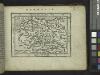
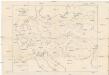
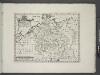
Germania.
from Abraham Ortelius his epitome of the theater of the worlde / nowe latlye ... renewed and augmented ... by Micheal Coignet, mathematitian of Antwarpe.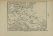
La Germanie à l’époque des invasions des Cimbres et des Teutons à travers l’Europe
Mitteleuropa Germanien Kimbern Teutonen Augustus
32. Mitteleuropa nach dem Reichsdeputationshauptschluss im Jahre 1803
Mitteleuropa Reichsdeputationshauptschluss
Post roads Germany, Hungary.
1 : 2500000 Robert Laurie & James Whittle
Eisenbahn-Übersichtskarte von Mittel-Europa
Evropa R. v. Waldheim
Geogr.-physik.-statist. Karte von Deutschland mit Einschluss von ganz Oesterreich, Belgien, den Niederlanden, der Schweiz, Italien und einem Theile von Frankreich, England, Russland und der Türkei
1 : 4110000 Evropa střední a východní Haurand Theobald Grieben
Carte des états slaves rendus indépendants par Samo, et groupés autour de lui (an 625 à 650), en face du royaume réduit des Avars, enserré à l’est par les Khazars et les Bulgares, et au sud et à l’ouest par les Slaves que l’empereur Héraclius avait établis au sud du Danube
Ostmitteleuropa Tschechische Republik Slawen Awaren Samo
2. Pyrenäenfriede 1659
1 : 30000000 Mitteleuropa Pyrenäenfriede
Map of the Post-Route to & from St. Petersburgh
1 : 24000000 Osteuropa Deutschland Polen Russland Reiseweg Postroute
Sbírka map a diagramů použitých na mírových konferencích v Paříži v letech 1919 - 1920

29. Mitteleuropa im Jahre 1650
Mitteleuropa
Prussia, and the German States.
from New general atlas.
Conspectus Generalis omnium earum partium quae unquam ad Imperium Francicum vel Franco-Romanum demum Romano-Germanicum diversis temporum periodis pertinuerunt.
1 : 11000000 Mollova mapová sbírka Homann, Johann Baptist Homann, Johann Baptista - dědici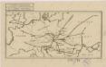
Sbírka map a diagramů použitých na mírových konferencích v Paříži v letech 1919 - 1920
Germany.
from A new sett of maps both of antient and present geography : wherein not only the latitude and longitude of many places are corrected according to the latest observations, but also the most remarkable differences of antient and present geography may be quickly discern'd by a bare inspection or comparing of correspondent maps, which seems to be the most natural and easy method to lead young students (for whose use the work is principally intended) unto a competent knowledge of the geographical science : together with a geographical treatise particularly adapted to the use and design of these maps / by Edward Wells, M.A. and student of Christ-Church, Oxon.
Conspectus Generalis omnium earum partium quae unquam ad Imperium Francicum vel Franco-Romanum demum Romano-Germanicum diversis temporum periodis pertinuerunt.
1 : 11000000 Mollova mapová sbírka Homann, Johann Baptist Homann, Johann Baptista - dědici
Die grossen Friedensschlüsse II (1735 - 1812). Frankreichs, Rußlands und Englands Vorschreiten 1801-1812
1 : 20000000 Mitteleuropa, Osteuropa, Napoleonische Kriege
Neue Ausgabe von Schulz's praktischer Reise-Karte mit Angabe der Distanzen und Eisenbahnen
Evropa střední Schulz, R. A. Artaria & Co.
Germania, Dacia.
1 : 13000000 Fenner, Rest.
Porostní mapa revíru Srbice
1 : 2880
[Centralis Europae]
Evropa střední Schedel, Hartmann
Říše Karla Velikého