Maps of Germany

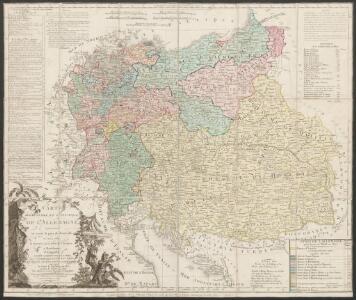
Carte élémentaire et statistique de l'Allemagne
1 : 2700000 Brion de La Tour, Louis Brion & Maire
Geogr.-physik.-statist. Karte von Deutschland mit Einschluss von ganz Oesterreich, Belgien, den Niederlanden, der Schweiz, Italien und einem Theile von Frankreich, England, Russland und der Türkei
1 : 4110000 Evropa střední a východní Haurand Theobald Grieben
Neue Ausgabe von Schulz's praktischer Reise-Karte mit Angabe der Distanzen und Eisenbahnen
Evropa střední Schulz, R. A. Artaria & Co.
Oesterreich in den Jahren 1564-1795
Evropa střední Gindely, Antonín F. Tempsky
Oesterreich im Jahre 1564, 1720, 1795.
Rakousko Benecke Bormann, E. F. Tempsky
Geogr.-physik.-statist. Karte von Deutschland mit Einschluss von ganz Oesterreich, Belgien, den Niederlanden, der Schweiz, Italien und einem Theile von Frankreich, England, Russland und der Türkei
1 : 4000000 Evropa střední Haurand, Theodor C. W.
Karte der floss- und schiffbaren Flüsse von Mittel-Europa
1 : 3000000 Evropa střední Jelussig, Othmar Kiepert, Heinrich
Die Deutschen Bundesstaaten, das Kaiserthum Oesterreich, das Königreich Preussen, die Schweiz, das Kgr. Belgien, das Kgr. der Niederlande u. die angrenzenden Länder von 1792 bis zur Gegenwart
1 : 7350000 Mitteleuropa
Übersichtskarte der Staaten von Mitteleuropa

Eisenbahn-Übersichtskarte von Mittel-Europa
Evropa R. v. Waldheim
Central-Europa
Mitteleuropa
Mittel-Europäische Staaten
Stieler's Hand-Atlas Stieler, Adolf bei Justus Perthes
Karte der Heilquellen und Kurorte von Mittel - Europa

Střední Evropa v době náboženské reformace a protireformace 1517 - 1648

Sbírka map a diagramů použitých na mírových konferencích v Paříži v letech 1919 - 1920

Post roads Germany, Hungary.
1 : 2500000 Robert Laurie & James Whittle
Germania, Dacia.
1 : 13000000 Fenner, Rest.
Fluss- u. Gebirgs-Karte, Mittel-Europa.
1 : 4500000 Flemming, Carl
Mitteleuropa
1 : 8000000 Evropa střední Kocen, Blaž Eduard Hölzel
Habsburger Monarchie 1772 nach der ersten polnischen Teilung
Österreich, Teilung Polens <1772> Kunz, Andreas ; Moeschl, Joachim Robert
Mitteleuropa: Konfessionsgebiete
1 : 9000000 Mitteleuropa Denomination
Prussia, and the German States.
from New general atlas.
German Empire.
1 : 6200000 Lavoisne, M.
Skelet zur Übersichtskarte von Mittel-Europa im Masse 1:750 000 und zur Hypsometrischen Karte der österr[isch-] ungar[ischen] Monarchie
1 : 750000 Rakousko-Uhersko R. Lechner
Völkerkarte von Mitteleuropa
1 : 9000000 Mitteleuropa Ethnische Gruppe
Eisenbahnkarte von Mittel Europa
1 : 3375000 Berlín (Německo) Broditzky, Joseph R. v. Waldheim
Eisenbahnkarte von Mittel Europa
1 : 3375000 Berlín (Německo) Broditzky, Joseph R. v. Waldheim
Eisenbahnkarte von Mittel Europa
1 : 3375000 Berlín (Německo) Broditzky, Joseph R. v. Waldheim
Eisenbahnkarte von Mittel Europa
1 : 3375000 Berlín (Německo) Broditzky, Joseph R. v. Waldheim