Maps of Lewisham

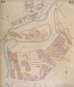
Insurance Plan of London East South East District Vol. H: sheet 9
1 : 480 This detailed 1897 plan of London is one of a series of thirteen sheets in an atlas originally produced to aid insurance companies in assessing fire risks. The building footprints, their use (commercial, residential, educational, etc.), the number of floors and the height of the building, as well as construction materials (and thus risk of burning) and special fire hazards (chemicals, kilns, ovens) were documented in order to estimate premiums. Names of individual businesses, property lines, and addresses were also often recorded. Together these maps provide a rich historical shapshot of the commercial activity and urban landscape of towns and cities at the time. The British Library holds a comprehensive collection of fire insurance plans produced by the London-based firm Charles E. Goad Ltd. dating back to 1885. These plans were made for most important towns and cities of the British Isles at the scales of 1:480 (1 inch to 40 feet), as well as many foreign towns at 1:600 (1 inch to 50 feet). Chas E Goad Limited Chas E Goad Limited
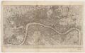
Insurance Plan of London East South East District Vol. H: sheet 10
1 : 480 This detailed 1897 plan of London is one of a series of thirteen sheets in an atlas originally produced to aid insurance companies in assessing fire risks. The building footprints, their use (commercial, residential, educational, etc.), the number of floors and the height of the building, as well as construction materials (and thus risk of burning) and special fire hazards (chemicals, kilns, ovens) were documented in order to estimate premiums. Names of individual businesses, property lines, and addresses were also often recorded. Together these maps provide a rich historical shapshot of the commercial activity and urban landscape of towns and cities at the time. The British Library holds a comprehensive collection of fire insurance plans produced by the London-based firm Charles E. Goad Ltd. dating back to 1885. These plans were made for most important towns and cities of the British Isles at the scales of 1:480 (1 inch to 40 feet), as well as many foreign towns at 1:600 (1 inch to 50 feet). Chas E Goad Limited Chas E Goad Limited
Insurance Plan of London East South East District Vol. H: sheet 8-1
1 : 480 This detailed 1897 plan of London is one of a series of thirteen sheets in an atlas originally produced to aid insurance companies in assessing fire risks. The building footprints, their use (commercial, residential, educational, etc.), the number of floors and the height of the building, as well as construction materials (and thus risk of burning) and special fire hazards (chemicals, kilns, ovens) were documented in order to estimate premiums. Names of individual businesses, property lines, and addresses were also often recorded. Together these maps provide a rich historical shapshot of the commercial activity and urban landscape of towns and cities at the time. The British Library holds a comprehensive collection of fire insurance plans produced by the London-based firm Charles E. Goad Ltd. dating back to 1885. These plans were made for most important towns and cities of the British Isles at the scales of 1:480 (1 inch to 40 feet), as well as many foreign towns at 1:600 (1 inch to 50 feet). Chas E Goad Limited Chas E Goad Limited
Surrey III.SE - OS Six-Inch Map
1 : 10560 Topographic maps Ordnance Survey Ordnance Survey
Kent I.SE - OS Six-Inch Map
1 : 10560 Topographic maps Ordnance Survey Ordnance Survey
PLAN SHEWING THE PROPOSED LINE of the LONDON AND GREENWICH RAILWAY
1 : 7200 The title of this plan appears at bottom left, with an explanatory note and scale bar at bottom centre. An illustration of the general construction of the railway features at bottom right. The Greenwich line reached Bermondsey in 1836. A year later, it reached London Bridege, which became the first railway terminus in the capital. Wyld, James
Insurance Plan of London East South East District Vol. H: Key Plan
1 : 10560 This "key plan" indicates coverage of the Goad 1897 series of fire insurance maps of London that were originally produced to aid insurance companies in assessing fire risks. The building footprints, their use (commercial, residential, educational, etc.), the number of floors and the height of the building, as well as construction materials (and thus risk of burning) and special fire hazards (chemicals, kilns, ovens) were documented in order to estimate premiums. Names of individual businesses, property lines, and addresses were also often recorded. Together these maps provide a rich historical shapshot of the commercial activity and urban landscape of towns and cities at the time. The British Library holds a comprehensive collection of fire insurance plans produced by the London-based firm Charles E. Goad Ltd. dating back to 1885. These plans were made for most important towns and cities of the British Isles at the scales of 1:480 (1 inch to 40 feet), as well as many foreign towns at 1:600 (1 inch to 50 feet). Chas E Goad Limited Chas E Goad Limited
London SE.
1 : 15840 Stanford, Edward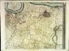
An exact survey of the city's of London Westminster , II
1 Blatt : 53 x 71 cm John Rocque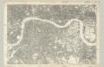
Surrey III - OS Six-Inch Map
1 : 10560 Topographic maps Ordnance Survey Ordnance Survey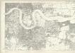
Essex LXXXI - OS Six-Inch Map
1 : 10560 Topographic maps Ordnance Survey Ordnance Survey
A colored plan, on vellum, of Southwark, and the country on the Surrey side of the Thames from Vauxhall to Deptford, with proposed roads from Westminster Bridge
To Martin Folkes esq.r, president of the Royal Society : this plan of the cities of London and Westminster and borough of Southwark, with the contiguous buildings is humbly inscribed
1 : 15000 Rocque, John, d. 1762 John Pine ; John Tinney, print and map sellar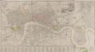
LONDON AND WESTMINSTER
The title of this map appears near the top right in a vignette depicting Father Thames, with compass rose at bottom right, scale bar at bottom centre, and an alphabetical list of streets in the table below the plan. Roads, open spaces and the built-up area within the city are depicted in colour. The boundaries of the 'Liberty’ of the Tower of London is similarly depicted in colour ('Liberty', in this sense, means an area of separate jurisdiction to the rest of the city). Finally, the map extends eastward to include the Isle of Dogs and the docks, which were then under construction. Fairburn, John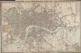
CROSS'S NEW PLAN OF LONDON 1828
The title of this folding map is inset in the top border, with the publisher's imprint and explanatory notes in the bottom border and a list of parishes in a table at top right. The map is divided into half-mile squares for reference, with the river, open spaces and the boundaries of London, Westminster and Southwark highlighted in different colours. Cross, Joseph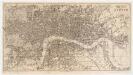
Reynolds's map of London : with the latest improvements
1 : 16000 Martin, Henry, fl. 1830-1852 J. Reynolds
TQ37 - OS 1:25,000 Provisional Series Map
1 : 25000 Topographic maps Ordnance Survey Ordnance Survey
London.
1 : 19495 Letts, Son & Co.
General Plan for Trusts of the Turnpike Gates
Cary, John
PLAN of LONDON
Only the main roads appear on this map, giving the appearance of a rather spacious capital city. The new London Bridge is shown without its approaches. Pecked lines show the intended location of the Thames Tunnel. Marc Brunel, father of the great engineer Isobard, solved the problem of how to bore through soft ground or under water, inventing the tunnelling shield. Both father and son worked on the tunnel which was completed as a foot tunnel in 1843, before becoming a railway tunnel for the East London Railway in the 1860s. The East and West India Docks are also shown. Phillips, Horatio
Map of London, shewing the BOUNDARIES of the GENERAL and Two Penny Post
This outline map of London was commissioned by the House of Commons for the21st Report of the Commissioners of Revenue Inquiry in 1830. The map's title features at top right, with the boundaries of the nine postal districts and those of the General-, Two- and Three-Penny Post deliveries outlined in colour. Boundaries are explained at top left with a key to colour usage in panel below the plan. Basire, James
Cary's new plan of London and its vicinity
Cary, John; Cary, George Cary
CRUCHLEY'S NEW POSTAL DISTRICT MAP OF LONDON
This map shows the division of London into ten post codes. The title appears along the top, with the publisher's imprint below the plan and a scale bar at bottom left. Also on the map are the Metropolitan Railway line to Finsbury, the proposed site of Charing Cross station (built in 1864) and the planned London, Chatham and Dover line. Cruchley, George Frederick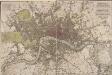
PIGOT & Co New Plan of London Taken from the Best Authorities
The title and publisher's imprint of this map appear at the top right, facing an explanatory note at top left. Squares, open spaces and the built-up area in the city are delineated in colour. A key to colours is provided at the bottom left. Published in Pigot's 'Metropolis Guide and Book of Reference', the map is divided into circles numbered for reference, showing Waterloo, Vauxhall and Battersea Bridges. Pigot, James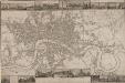
LANGLEY & BELCHE'S NEW MAP OF LONDON
Proof before letters is the term for an impression of a print withdrawn before the title is added to the image prior to publication. This is a proof before letters copy of Langley & Belche's 1812, with illustrated views of prominent London buildings (including the newly opened docks) along the top and bottom of the plate. The plan is divided into lettered squares for reference. It was originally accompanied by Langley & Belch's street directory or 'Companion to their new map of London'. Langley, Edward & Belch, William
LAURIE and WHITTLE NEW MAP OF LONDON WITH ITS ENVIRONS &C. Including the Recent Improvements
The title of this map of London and suburbs appears at top left, with the key to symbols and abbreviations at the top right and a compass rose at the bottom centre. The map is divided into mile squares with borders marked off in furlongs for reference. Squares, open spaces and city boundaries are distinguished in colour. This is a later edition of a map first issued in 1804, updated to include the new bridges and the approaches at Waterloo and Vauxhall (indicated by dotted lines). Built between 1809 and 1819, Vauxhall, Waterloo and Southwark bridges were projected, funded and constructed by private commercial companies hoping to profit from toll-paying traffic from Lambeth, Camberwell and the rest of south London. Laurie, Robert and Whittle, James
LAURIE'S NEW PLAN OF LONDON and its ENVIRONS with an Improved Scale FOR ASCERTENING DISTANCES
Map of London and the suburbs with title, imprint and dedication to Lord Viscount Melbourne in table at top right. Below the title, a note explaining that the map was based on the trigonometric survey by General Roy "combined with a new series of 52 stations on elevated situations from which the positions of upward to of 450 steeples, domes, turrets, vanes and other conspicuous objects within the limits of the plan, have been determined by means of more than 5000 angles." Laurie, Richard Holmes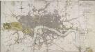
LONDON IN MINIATURE WITH THE Surrounding AN ENTIRE NEW PLAN In which the Improvements both present and intended are actually reduced (by permission) from the surveys of Several Proprietors
The title of this map appears at top right, with scale bar at the bottom centre, and a compass rose near top left. Watercourses, roads and open spaces are depicted in colour. The map shows the proposed new bridges at Waterloo and Vauxhall, extending eastward on an added sheet to include the Isle of Dogs. Mogg, Edward
Bez titulu: London