Maps of Lewisham

Insurance Plan of London East South East District Vol. H: sheet 10
1 : 480 This detailed 1897 plan of London is one of a series of thirteen sheets in an atlas originally produced to aid insurance companies in assessing fire risks. The building footprints, their use (commercial, residential, educational, etc.), the number of floors and the height of the building, as well as construction materials (and thus risk of burning) and special fire hazards (chemicals, kilns, ovens) were documented in order to estimate premiums. Names of individual businesses, property lines, and addresses were also often recorded. Together these maps provide a rich historical shapshot of the commercial activity and urban landscape of towns and cities at the time. The British Library holds a comprehensive collection of fire insurance plans produced by the London-based firm Charles E. Goad Ltd. dating back to 1885. These plans were made for most important towns and cities of the British Isles at the scales of 1:480 (1 inch to 40 feet), as well as many foreign towns at 1:600 (1 inch to 50 feet). Chas E Goad Limited Chas E Goad Limited
Insurance Plan of London East South East District Vol. H: sheet 9
1 : 480 This detailed 1897 plan of London is one of a series of thirteen sheets in an atlas originally produced to aid insurance companies in assessing fire risks. The building footprints, their use (commercial, residential, educational, etc.), the number of floors and the height of the building, as well as construction materials (and thus risk of burning) and special fire hazards (chemicals, kilns, ovens) were documented in order to estimate premiums. Names of individual businesses, property lines, and addresses were also often recorded. Together these maps provide a rich historical shapshot of the commercial activity and urban landscape of towns and cities at the time. The British Library holds a comprehensive collection of fire insurance plans produced by the London-based firm Charles E. Goad Ltd. dating back to 1885. These plans were made for most important towns and cities of the British Isles at the scales of 1:480 (1 inch to 40 feet), as well as many foreign towns at 1:600 (1 inch to 50 feet). Chas E Goad Limited Chas E Goad Limited
London XII.21 - OS London Town Plan
1 : 1056 Topographic maps Ordnance Survey Ordnance Survey
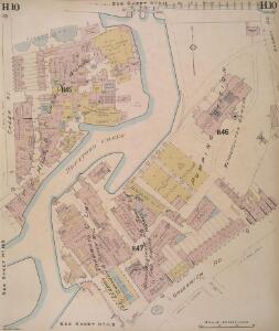
Insurance Plan of London East South East District Vol. H: sheet 11
1 : 480 This detailed 1897 plan of London is one of a series of thirteen sheets in an atlas originally produced to aid insurance companies in assessing fire risks. The building footprints, their use (commercial, residential, educational, etc.), the number of floors and the height of the building, as well as construction materials (and thus risk of burning) and special fire hazards (chemicals, kilns, ovens) were documented in order to estimate premiums. Names of individual businesses, property lines, and addresses were also often recorded. Together these maps provide a rich historical shapshot of the commercial activity and urban landscape of towns and cities at the time. The British Library holds a comprehensive collection of fire insurance plans produced by the London-based firm Charles E. Goad Ltd. dating back to 1885. These plans were made for most important towns and cities of the British Isles at the scales of 1:480 (1 inch to 40 feet), as well as many foreign towns at 1:600 (1 inch to 50 feet). Chas E Goad Limited Chas E Goad Limited
Map of Deptford, with annotations on population growth by John Evelyn
This is a map of the dockyard and town of Deptford in 1623, with additions by John Evelyn, including (near the lower edge of the map) the only known original drawing of Sayes Court house. Writing in 1703, Evelyn notes the great increase in the population of Deptford since the map was made, commenting that, "the Town is in 80 yeares become neere as big as Bristoll". At this time the 3 largest cities in the country were London, Norwich and Bristol, so this statement demonstrates how rapidly Evelyn perceived the town to have grown in his lifetime. Evelyn, John
A MAP OF DEPTFORD, 1623. From an Original Pen and Ink Sketch with additional remarks by JOHN EVELYN, ESQ.R
Engraving of the map of Deptfordof 1623 with the addition madeby John Evelyn, including (near the lower edge of the map) the only known original drawing of the manor house at Sayes Court. Writing in 1703, Evelyn notes the great increase in the population of Deptford since the map was made, commenting that, "the Town is in 80 yeares become neere as big as Bristoll". At this time the 3 largest cities in the country were London, Norwich and Bristol, so this statement demonstrates how rapidly Evelyn perceived the town to have grown in his lifetime. Evelyn, John
London (1915- Numbered sheets) X.5 (includes: Borough Of Greenwich; Lewisham) - 25 Inch Map
1 : 2500 Topographic maps Ordnance Survey Ordnance Survey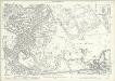
London (Edition of 1894-96) CV (includes: Borough Of Greenwich; Lewisham) - 25 Inch Map
1 : 2500 Topographic maps Ordnance Survey Ordnance Survey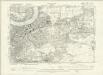
London XII.NW - OS Six-Inch Map
1 : 10560 Topographic maps Ordnance Survey Ordnance Survey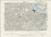
Surrey III.SE - OS Six-Inch Map
1 : 10560 Topographic maps Ordnance Survey Ordnance Survey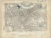
Kent I.SE - OS Six-Inch Map
1 : 10560 Topographic maps Ordnance Survey Ordnance Survey
PLAN SHEWING THE PROPOSED LINE of the LONDON AND GREENWICH RAILWAY
1 : 7200 The title of this plan appears at bottom left, with an explanatory note and scale bar at bottom centre. An illustration of the general construction of the railway features at bottom right. The Greenwich line reached Bermondsey in 1836. A year later, it reached London Bridege, which became the first railway terminus in the capital. Wyld, James
Insurance Plan of London East South East District Vol. H: Key Plan
1 : 10560 This "key plan" indicates coverage of the Goad 1897 series of fire insurance maps of London that were originally produced to aid insurance companies in assessing fire risks. The building footprints, their use (commercial, residential, educational, etc.), the number of floors and the height of the building, as well as construction materials (and thus risk of burning) and special fire hazards (chemicals, kilns, ovens) were documented in order to estimate premiums. Names of individual businesses, property lines, and addresses were also often recorded. Together these maps provide a rich historical shapshot of the commercial activity and urban landscape of towns and cities at the time. The British Library holds a comprehensive collection of fire insurance plans produced by the London-based firm Charles E. Goad Ltd. dating back to 1885. These plans were made for most important towns and cities of the British Isles at the scales of 1:480 (1 inch to 40 feet), as well as many foreign towns at 1:600 (1 inch to 50 feet). Chas E Goad Limited Chas E Goad Limited
London SE.
1 : 15840 Stanford, Edward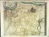
An exact survey of the city's of London Westminster , II
1 Blatt : 53 x 71 cm John Rocque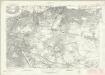
London Sheet P - OS Six-Inch Map
1 : 10560 Topographic maps Ordnance Survey Ordnance Survey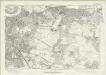
London Sheet P - OS Six-Inch Map
1 : 10560 Topographic maps Ordnance Survey Ordnance Survey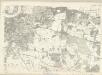
Middlesex XXIII - OS Six-Inch Map
1 : 10560 Topographic maps Ordnance Survey Ordnance Survey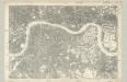
Surrey III - OS Six-Inch Map
1 : 10560 Topographic maps Ordnance Survey Ordnance Survey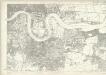
Essex LXXXI - OS Six-Inch Map
1 : 10560 Topographic maps Ordnance Survey Ordnance Survey
A colored plan, on vellum, of Southwark, and the country on the Surrey side of the Thames from Vauxhall to Deptford, with proposed roads from Westminster Bridge
To Martin Folkes esq.r, president of the Royal Society : this plan of the cities of London and Westminster and borough of Southwark, with the contiguous buildings is humbly inscribed
1 : 15000 Rocque, John, d. 1762 John Pine ; John Tinney, print and map sellar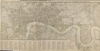
ROWE'S PLAN OF LONDON, WESTMINSTER and SOUTHWARK, exhibiting the various IMPROVEMENTS, to the Year 1804 with the LONDON and WEST INDIA DOCKS
The title of this map appears along the top, with the table of reference in a panel below the plan and scale bar at bottom right. The map is divided into rectangles for reference and shows the newly built London and West India Docks on the Isle of Dogs. Designed by William Jessop, the docks were completed in 1802 allowing West India Company merchants to discharge their ships in four days instead of the usual four weeks. Rowe, Robert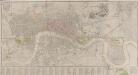
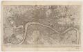
LONDON AND WESTMINSTER
The title of this map appears near the top right in a vignette depicting Father Thames, with compass rose at bottom right, scale bar at bottom centre, and an alphabetical list of streets in the table below the plan. Roads, open spaces and the built-up area within the city are depicted in colour. The boundaries of the 'Liberty’ of the Tower of London is similarly depicted in colour ('Liberty', in this sense, means an area of separate jurisdiction to the rest of the city). Finally, the map extends eastward to include the Isle of Dogs and the docks, which were then under construction. Fairburn, John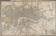
CROSS'S NEW PLAN OF LONDON 1828
The title of this folding map is inset in the top border, with the publisher's imprint and explanatory notes in the bottom border and a list of parishes in a table at top right. The map is divided into half-mile squares for reference, with the river, open spaces and the boundaries of London, Westminster and Southwark highlighted in different colours. Cross, Joseph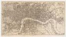
Reynolds's map of London : with the latest improvements
1 : 16000 Martin, Henry, fl. 1830-1852 J. Reynolds
TQ37 - OS 1:25,000 Provisional Series Map
1 : 25000 Topographic maps Ordnance Survey Ordnance Survey
London.
1 : 19495 Letts, Son & Co.
General Plan for Trusts of the Turnpike Gates
Cary, John